Jay Peak 186k Ride Report, Saturday, June 2, 2007
Ride summary:
·
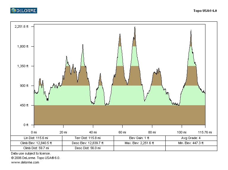
Stats:
115.8 mile figure eight circuit, 8 significant climbs, 12,800 feet of climbing
(per TopoUSA)
·
Solo
ride, finished in 6:56 riding time, less than 8hrs total time
·
Stopped
twice for food and water on muggy 70’s degree day
The Jay Peak
ride presented here is a hybrid ride report/review. Comparing the Jay Peak
186k with 6-gaps, the Jay ride offers far more scenery. Most of 6-gaps lies
in the Green Mountain National Forest. It is heavily forested. The only views are open grazing areas from
valley floors or from summits of a few of the gaps. The Jay ride on the other hand, lies mostly
in agricultural and private land. Much
more of the land is cleared, especially at some of the higher elevations. There are many large mountain peaks in the
area too, giving more of a sense of riding in the mountains.
This ride
is a nice alternative to the 6-gaps ride.
The climbs are much gentler, but the ride entails nearly as much total
climbing and distance. It will take a
lot out of you. The steepest segment
along the route is climbing Rt 242 west, the upper
portion above Jay
Peak ski area
entrance. There’s about a half mile of
14%. Compare this to 1.5 miles of 20-24%
grade found in 6-gaps. Triples are not
required for the Jay
Peak ride, and most
strong riders will do well with 39x27 or 34x25 gearing. I used 34x27 on my maiden voyage of this
loop, not knowing what to really expect.
I did use the 27t cog a couple times, once on the steep part of Rt 242, and again at the end coming up Smugglers Notch when
I was tired.
Each of
the significant climbs on this ride is briefly discussed below. The elevation numbers given are min to max,
from low point since last climb to high
point. Total climbing
may be much more, as there may be down hills along the way up. For a map showing route, go to http://www.northeastcycling.com/gpx_loader.html
and select the Smugglers-Jay Century in VT.
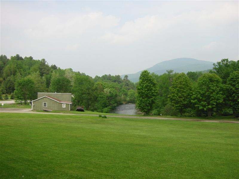
Stagecoach Rd – 362ft
The ride
begins and finishes in Stowe,
VT. This tourist town can be busy in summer
months, but I had no trouble finding place to leave car for the day. Most parking spots say two hour maximum or
are reserved, so be careful. Start ride
by heading north on Rt 100. In a couple miles, take Stagecoach Rd to the left. This will have much less traffic on it. You soon will encounter a steep little climb
to get the blood going in the legs. Bear
left on Cadys
Falls Rd which becomes Depot St in town of Hyde Park.
A left on Main then right on Church should take you to Rt 100 north directly across highway 15. It’s tricky.
I screwed it up and went all the way up Rt 15
to Rt 100c before I got back
on course. Most signage appears to be
local names for roads, not state route numbers you see on maps.
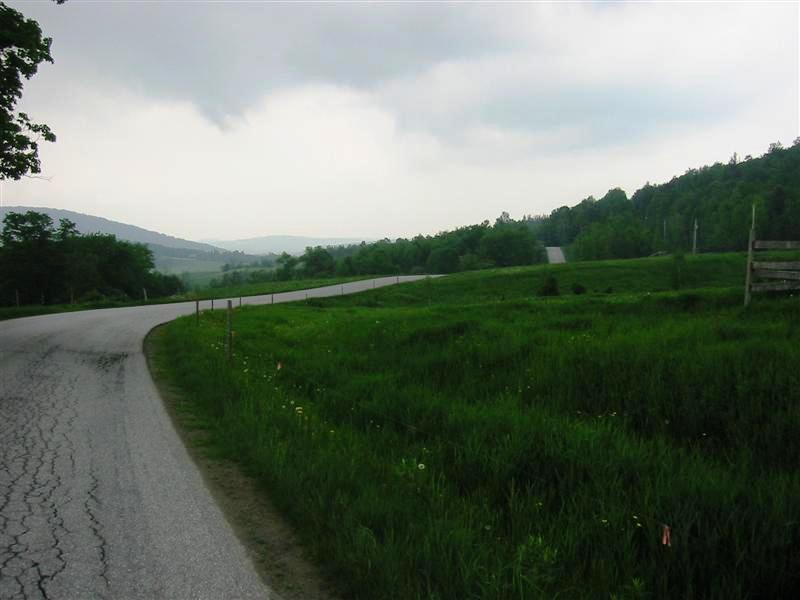
The Knob (North Rd/Mines Rd) – 1031ft
Continue
north on Rt 100 to about 1.5 miles past junction with
Rt 118. You
will be gaining lots of elevation on Rt 100 in
spurts. Take left on North Rd, climbing more steeply now, gaining
a few hundred more feet to high point
of this road over the next mile. This
road has minimal traffic and some great views.
It passes by the closed asbestos mines on Belvidere Mtn. This was the first asbestos mine to open in
the USA
and at one time supplied nearly the entire US’s asbestos demand. We now know this stuff is evil, so the mines
closed several years ago. The mine
tilling piles are quite amazing.
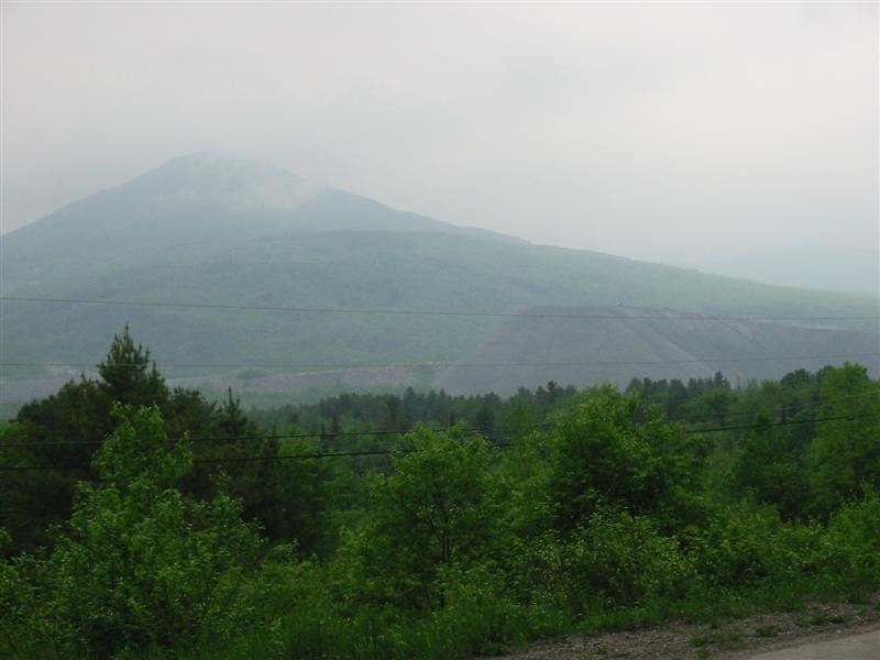
Belvidere Mtn, note
mine tillings in center right of image. Passed below these further
down road, and they looked like
mountains in their own right.
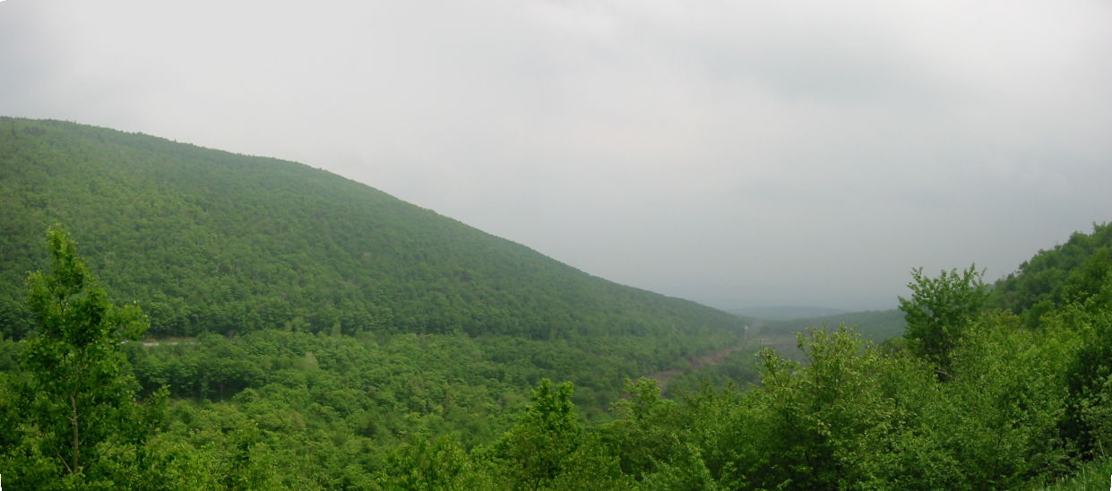
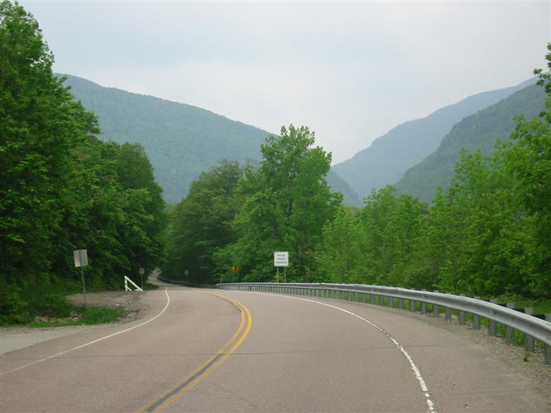
Hazen’s Notch – 873ft
North Rd becomes Mines Rd.
After brief descent, a hard left is taken at the tee junction of highway
58. I saw no signs here, but the back side
of a sign in uphill direction had a faded “58” on it. Rt 58 is a seasonal
road, closed in the winter months. Rt 58 is paved here, but shortly turns to gravel. Yes folks, Vermont still has
state highways that are not paved.
Upwards of 8 miles of Rt 58 is unpaved, up and
over Hazen’s Notch. There is a state
campground near the top on this side of the notch. This was the high point of the ride for me. Near nil traffic, perfect gravel condition,
mild temps, and great early summer scents on the breeze. It had been raining a lot recently, so this
probably had the gravel condition in much better form than usual. You get glimpses of the notch as you climb,
and it gets pretty steep just as you reach the top. The Long Trail crosses here, a trail this
ride will cross three more times. This
descent was wonderful on the day I rode.
It is very steep initially with some washboard bumps coming into the
switchbacks. Be very careful. But a little further down, I could really let
my speed run out, hitting 39.5mph two different times. The descent continues the last mile or two on
pavement into the village
of Montgomery Center.
Climbing towards Hazen’s Notch in distance.
Beginning descent to Montgomery
Center from Hazen’s
Notch.
Cliffs loomed on
either side of notch.
Fuller Bridge/Richford Rd – 700ft
After
refueling in Montgomery Center (multiple options
in town), head north on Rt 118 (aka
North Main St)
about 2.5 miles to Montgomery. There is also a general store there. Look for the covered bridge on Fuller Bridge Rd
and go through it. This road climbs
briskly a couple times before leveling off some. The views abound. Richford
Rd tops out at around 1200ft elevation and has
lots of open pasture. The descent to
Richford is particularly nice with mountain peaks on the other side of the
Canadian border. You will see other
covered bridges on this ride. For more
on Fuller Bridge, see http://www.vermontbridges.com/fuller.recon.htm.
Richford Rd, near high point. Lots of open valley views here. Threat of
rain seemed ever present during this
ride.
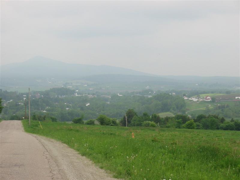
Mont Pinacle in Quebec in distance. Too bad it was so humid and hazy
this day.
Beats the forecasted 64% chance of thunderstorms though. I stumbled upon a much
nicer photo looking for the name of this
mountain here.
Jay Peak North – 1643ft
Having
bombed down Richford Rd
to Rt 105, take a right. Note that many of the state highways in this
area are not named with Rt #’s. They will be named local street names. Rt 105 is the road
that hugs the wide Missisquoi River,
and I didn’t see a street sign. The
pavement starting out on Rt 105 is nasty in spots. The good thing was, on the Saturday in early
June when I rode this, there was minimal traffic. It was easy to avoid the cracked up
parts. It was common to go five minutes
at a time with no cars passing in either direction. Once the road veers away from the river, get
ready for the first serious climb of the ride.
Again, nothing uber steep, but the climb goes
on for nearly 8 miles. There are a
couple flats or even slight down hills on the way up. Part way up this climb, you will be less than
1km from the border with Canada. Just after cresting the top (you will know
when you finally hit the top when you see the “trucks use low gear” sign), look
for the pull-off on the right for a fantastic view of the descent. The descent offered much nicer pavement than
the lower part of the climb. You can
take this all the way down to Rt 100, but I decided
to avoid any traffic and took a right on Cross Rd.
Cross Road
has been recently paved and continues downward slightly.
Beginning descent on Rt 105 towards Troy. Looks
like rain in Troy.
Jay Peak South – 1338ft
When you
reach Rt 242, take a right. There is a gas/convenience station here. This begins the second serious climb of the
ride. Rt 242
for the next few miles is also in very rough shape. Again, there was little traffic to contend
with. You will climb steadily for 4
miles. The view of Jay
Peak will loom above you, and you get
an idea of where the pass traverses to the south of Jay Peak. You will pass the Jay Peak
ski area and then crest what you think is the top of the climb. Nope.
A descent and sweeping turn will bring a shocking view to your eyes, a
half mile, 14% grade wall. Just hunker down and grind it out. This is the steepest part of the whole ride. When you reach the top, you realize it wasn’t
so bad after all. Now get ready for a
rocket descent back to Montgomery
Center. The pavement is decent all the way to town,
but it does have some repetitious bumps in it.
This will be the biggest descent of the ride, over 1700ft drop. You can stop at the same general store you
may have stopped at before circumnavigating Jay Peak. When I did the ride, I stopped twice, and at
the some store in Montgomery
Center. You pass through Montgomery Center
at roughly the 1/3 and 2/3 points in the ride.
The at this point has circumnavigated Jay Peak
and crossed the Long Trail two more times.
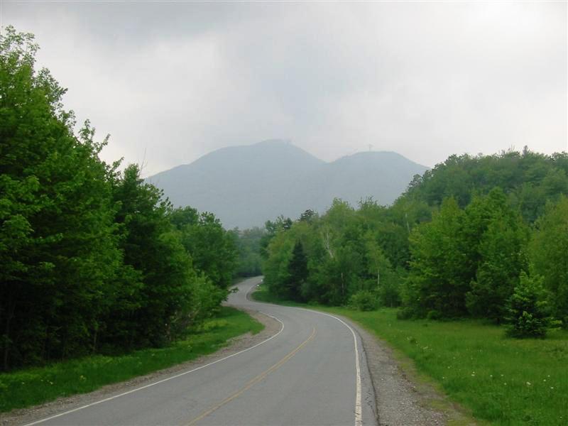
Approaching Jay
Peak. The ski runs were visible to the
eye, but the humidity washes them
out for the camera. You could see Jay Peak
from many points of the ride, and at earlier times
it was shrouded in very dark clouds.
Rt 118/109 – 749ft
After
refueling, you will now take the only other route out of Montgomery Center
you haven’t been on yet. That is Rt 118 south. This
is another road that is many years past due for repaving. But like most of the roads in this area,
there simply wasn’t much traffic to contend with. You will climb gradually for 8 miles. When reaching the junction with Rt 109 in Belvidere Corners, bear
right. There will be a couple of
moderately steep short climbs on this road.
Rt 109 has been recently resurfaced and was
wonderful to ride on. After cresting the
last roller, you will have nearly 14 miles of gradual, mostly down hill to
enjoy. It follows the north branch of
the Lamoille River.
The views are fantastic on this section of the ride too. Much of the road is benchcut
into one side of the valley it lies in, and you view big mountains down and
across the valley the whole way. This is
part of what makes riding in Vermont
so rewarding. This and
very little traffic and country stores that haven’t changed in a century in
every village.
Looking back north
along Rt 109.
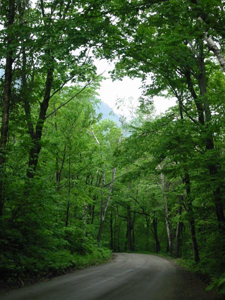
Smugglers Notch – 1735ft
Have to
save the best for last. Smugglers Notch
is the most unique notch in all of New England
in my opinion. It is very narrow with
towering 2000ft cliffs on either side.
It always seems to be 10 degrees cooler in the notch than elsewhere
too. It is heavily canopied, but there
are just enough open spots to see what towers above you. Smugglers Notch is the single biggest net
gain climb of the ride, gaining 1735ft from Jeffersonville to the top in near monotonic
fashion. There’s a steep section
approaching the notch, a half mile averaging 10%. Other than that, the climb is not too bad
from this side. The descent back to
Stowe is much steeper initially, easily over 12%. Another reason for finishing with Smugglers
Notch is the 10 mile descent back to Stowe.
It is a wonderful way to finish the ride. No or very light pedaling all
the way back to your car is a great way to cool down after the biggest climb of
the ride.
From upper parking areas of Smugglers Notch ski area looking into notch.
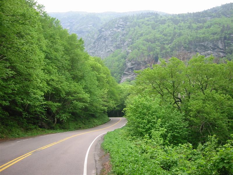
Final approach into Smugglers Notch from the north.
Ride Wrap-Up
So you
may ask “I add up all these verticals and don’t get anything near
12,800ft. What gives?” We’ll, as already mentioned, the listed verticals
are simple min to max differences for significant climbs. There are numerous smaller climbs along this
route. Plus, most of the significant
climbs are not monotonic, that is, they have rollers on the way up. This means you climb some of the same
vertical twice before reaching the high
point.
This ride
was thoroughly rewarding, one I’ll have to repeat when I can get a group to head
back up with me. It didn’t seem that
hard during the ride, as none of the hills were seriously steep like in the
6-gaps ride. But I was totally depleted
after the ride. In some ways, rides with
lots of small rolling hills can be harder than rides with a few big climbs. On small hills, you tend to power into
them. You approach the hill fresh,
charge up in a big gear, knowing it will be over shortly. But you go deep into the red each time. When doing a long ride with fewer but bigger
climbs, you tend to easy into the climb, staying out of the red. If you did charge into a long climb, you
would soon be forced to back down anyway.
I probably logged more time above say 350W on this ride than I did on
any 6-gaps ride I’ve done.
The
scenery here is unforgettable. You don’t
have to go to Colorado
to find low traffic, mountainous routes to ride. True, you won’t have 14,000ft peaks towering
above you here, but it is very green, steeply contoured, and a place time has
not caught up to yet.
-Doug