Six Gaps
We began our Six Gap Ride at a dirt pull off at the
intersection of Rts 100 and 73 in
The Six Gap Ride is a ride in the Green Mountains north of
Brandon Gap – 600’ in
Although it is not the smallest gap, it does seem to be the easiest – maybe because it is first and we were trying to take it easy the first few gaps – 132 miles is a long way.
To the right on the ascent is
Middlebury Gap – 375’
in Middlebury to 2144’
Middlebury Gap begins with a gentle 1 mile incline leading into a moderately steep curving pitch. From there it is nearly 10 miles of long gradual climbs, seeming tops, short descents and more gradual climbs. You pass through the towns of Ripton and Bread Loaf. The road is in good shape and there is great countryside throughout the climb. Just as we were beginning to wonder (for the third or fourth time) how long this can go on the road takes a tilt up for a reasonably long, I am guessing, ¾ mile, challenging finish.
We arrived at the top of Middlebury gap after 2h30m in the saddle and 2h41m after starting. We all felt good and were ready for more.
The initial descent is a steep 2 miles of pretty good road
where speeds in excess of 50 are easy to achieve. From there it is 5+ miles of gradual downs
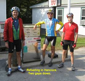
into Hancock. It is a ride of 20+ miles
to the next gap and we rode a fast paceline through
the towns of Lower and
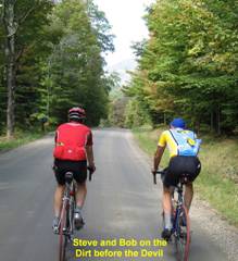 The
start of the climb is paved and has a short steep section. From there the climb is gentle. After a mile or two it turns to gravel. The gravel continues for a few more
miles. It is generally in good shape
although you may not be able to ride at speeds you normally might due to
occasional potholes and wash boarding.
There are a few areas of short steeper pitches but generally it is flat
or gradual incline. When the gravel ends
the pavement and fun begins. It is time
to stop and remove your helmet. From
here the road climbs just over one mile at a persistent 20%. Initially there are a few spots that offer
short (real short) sections of maybe 12%.
Enjoy them – 12% never felt so good. With a half mile to go these short relief
spells are gone and the final pitch is a steep grind – some sections said to be
as steep as 24%. Can you balance at 3.5
mph and grind 350-400 Watts? If so, you
will emerge from the pain cave on your bike and on top. We all had gearing close to 1:1. I wouldn’t suggest anything harder than this
for
The
start of the climb is paved and has a short steep section. From there the climb is gentle. After a mile or two it turns to gravel. The gravel continues for a few more
miles. It is generally in good shape
although you may not be able to ride at speeds you normally might due to
occasional potholes and wash boarding.
There are a few areas of short steeper pitches but generally it is flat
or gradual incline. When the gravel ends
the pavement and fun begins. It is time
to stop and remove your helmet. From
here the road climbs just over one mile at a persistent 20%. Initially there are a few spots that offer
short (real short) sections of maybe 12%.
Enjoy them – 12% never felt so good. With a half mile to go these short relief
spells are gone and the final pitch is a steep grind – some sections said to be
as steep as 24%. Can you balance at 3.5
mph and grind 350-400 Watts? If so, you
will emerge from the pain cave on your bike and on top. We all had gearing close to 1:1. I wouldn’t suggest anything harder than this
for
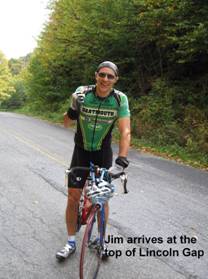
This is the highest point of the ride. In some perverse sense it is all down hill
from here and oddly there is no top to this gap. It starts down immediately. I don’t think you could balance a golf ball on
the top. The initial descent is no
fun. It is very steep and the pavement
is in bad, gravely condition. We stopped
every minute or so to cool our rims. It
soon turns to gravel and becomes less steep.
Some braking was still required but at least you weren’t trying to stop
on a 20% grade. As the gravel proceeds
the pavement becomes better and the few mile ride into
Appalachian Gap –
615’ to 2365’
 The
gap starts out gradually. After several
miles of gradual climbing we started a long gradual downhill - maybe 1-2
miles. We couldn’t believe we had just
done Appalachian Gap… Well, we
hadn’t. In fact, we really hadn’t even
started. This gap is tough! After quite a bit of climbing a large group
of communication towers becomes visible way up on the ridge. I am thinking they must be on the top of a
mountain and we will pass through a saddle well underneath them. No such luck.
The last 1500 meters of this climb is steep – 18% - and brings you right
to those towers. If you are wearing a pacemaker all the RF will probably have
your heart rate at 200 bpm as mine seemed to be, even
without a pacemaker. Along the way there
are kilo markers for the Green Mountain Stage Race. You can treat these as good news or bad.
The
gap starts out gradually. After several
miles of gradual climbing we started a long gradual downhill - maybe 1-2
miles. We couldn’t believe we had just
done Appalachian Gap… Well, we
hadn’t. In fact, we really hadn’t even
started. This gap is tough! After quite a bit of climbing a large group
of communication towers becomes visible way up on the ridge. I am thinking they must be on the top of a
mountain and we will pass through a saddle well underneath them. No such luck.
The last 1500 meters of this climb is steep – 18% - and brings you right
to those towers. If you are wearing a pacemaker all the RF will probably have
your heart rate at 200 bpm as mine seemed to be, even
without a pacemaker. Along the way there
are kilo markers for the Green Mountain Stage Race. You can treat these as good news or bad.
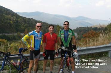
The other gaps are “tunnel-like” gaps due to the effect of
trees overarching the narrow roads. App
gap, however, is wide and offers great vistas to the Adirondacks to the west
and the
The descent is wonderful – steep, sharp sweeping turns. With the sun and changing colors it was a real treat. But be careful, some of the switchbacks are very sharp and if you are going too fast you will have ridden your last gap. We arrived in Waitsfield and refueled.
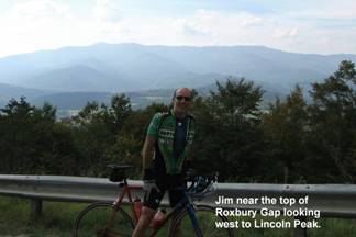
Roxbury Gap - 882’ in
A few miles out of
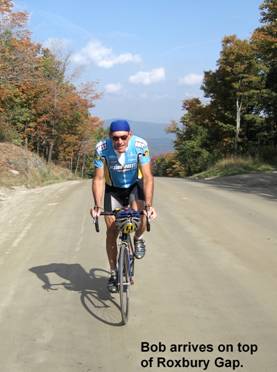
As a sidebar, you need to start each of these gaps with a full two bottles of water. The water loss on these climbs becomes incredible. Steve almost didn’t fill his second water bottle in Waitsfield. But by the top of Roxbury they were both empty. I had a little extra water but he only had $30. That would not have bought much water on the top of Roxbury Gap.
The descent is a lot of gravel so go easy. Steve flatted half way down and we fixed the
flat in a shaded portion of the road along a small brook leading into the
In Roxbury we fueled up and began a 25 mile ride along
routes 12A and 12. It is relatively flat
and we made good time pulling into a light headwind. Try to take advantage of this flat to work a
little life back into your legs because after the right on
Rochester Gap is a deceptively long gap. Like all the others it starts out with
several miles of gentle incline and when it starts getting steep what it lacks
in pitch it makes up in length. At the
top there are a few false peaks and some meandering roadway before you start
down. Allegedly there are pretty views
front and back but we had lost our enthusiasm.
The end of our ride was looking a lot better than any views could have
been. We took a left at the first four
way stop and from there it was a wonderful, forest canopied downhill into the
center of the town of
At the car -- WOW we did it! There were smiles, congratulations and a REAL sense of accomplishment. This was an incredible ride!
Two days later I feel great. Next year it is not a question of whether we can do the ride but how fast!
Final stats:
- Saddle time 8h40m, total ride time 10h05m
- Effort expended 5678 kjoules by Bob,172 lbs..
- Distance 133.2 miles
- Altimeter reading 12,660 vertical feet, DeLorme Topo 5.0 14,500 feet.