Last Update: 1-JUL-2013

Doug's
Trail Ride Log
Here’s a comprehensive list
of places I’ve ridden. Reviews for most of these rides can be found on MTBreview.com. My goal is to ride on
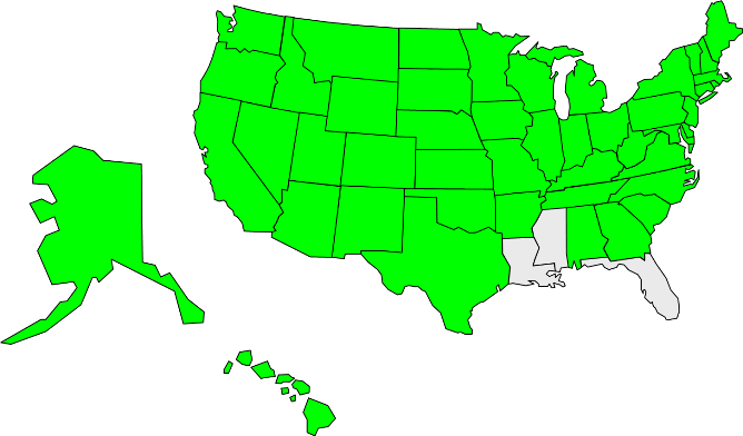
dirt in all 50 states before I leave this world. The map below highlights
in green the states I have ridden. So far I have ridden in 47 states, plus
three countries on two continents. Detailed “Doug’s Dozen” trail reviews follow the list. The list continues to grow each year, as trips out west and to other parts of the country seek out new singletrack. I’m always
searching for that perfect singletrack. A couple rides in I’ve done in Colorado will be hard to beat.
Alabama
- Cheaha State Park, Delta Highest peak
in AL, awesome rocky singletrack, great view from Bald Rock
- Choccolocco State Forest, Anniston
Several singletrack loops, climbing on Iron Legs, speed on Mark’s Loop
Alaska
- Powerline Pass, Anchorage Steep jeep
road climb and hairball descent from 3500ft to sea level
- Lost Lake/Primrose, Seward Prestine singletrack
climb to Lost Lake, descent on Primrose
- Resurrection Pass/Devils Pass, Cooper Landing Epic
singletrack loop of waterfalls, lakes, and tundra
- Johnson Pass, Moose Pass Epic singletrack
loop of waterfalls, lakes, and tundra
- Denali National Park Dirt road out and back,
stunning scenery and wildlife, major climbing
- Eklutna Lakeside Trail, Eklutna Dirt access
road/ATV trail along lake, then river to glacier. Great views
- Tony Knowles Path/Kincaid Park, Anchorage Paved
bike path out to XC trail system. Steep rolling terrain in Kincaid
Arizona
- 50 Year Trail, Tucson Fun, technical singletrack,
try the “chutes.” Gets more challenging as you go up.
- Arizona Trail, Box Canyon to Pistol Hill Site of the annual “Soul
Ride.” Nearly all singletrack, very steep, technical switchbacks.
- Arizona Trail, Picket Post to Kelvin Incredibly remote canyons scenery. No easy bailouts.
- Bell Rock/Courthouse Loop, Sedona Network of
easy trails, neat red rock features, tourists
- Black Canyon Trail, Black Canyon City Long point-to-point trail, remote, buff and scenic.
- Brown Mtn Loop, Tucson Climbs to ridgeline, follows with great views, and high pucker factor switchbacks down
- Bug Springs, Tucson High up on Mt Lemmon, spectacular descent back to hwy
- Charouleau Gap, Tucson Jeep road climb, singletrack
descent back to Catalina State Park. Tough and isolated.
- Chiva Falls,Tucson Jeep road out to Chiva Falls (in the Desert!). Technical, don’t ride it alone like I did!
- Dead Horse State Park, Cottonwood Thumper loop,
singletrack in open desert, couple gnarly spots
- Fantasy Island, Tucson About 15 miles of
MTBer built singletrack with amusement park roller coaster fun
- Highline & Hog loop, Sedona Trecherous exposure on both trails, continuous views, crazy descents
- Llama/Broken Arrow/Sub Rock/Templeton, Sedona Premier
loop, many tourists, lots of slickrock
- Mt Graham, Safford 31 mile, 7,105 foot climb from
town to summit of Heliograph Peak. Mostly Paved.
- Mt Hopkins, Amado 19.3 mile, 5515 foot gain on dirt
road to summit at 8585 feet. Stunning views.
- Jim Thompson/Jordan/Teacup Loop, Sedona Classic
Sedona singletrack on west side
- Kitt Peak, Pan Tak 12.1 mile, 3630 foot gain on
paved road to summit at 6870 feet.
- Mt Lemmon, Tucson 27 mile climb from downtown,
nearly 7000ft if go to summit. Paved.
- McDowell Mtn Park, Scottsdale Mostly easy,
buttery smooth singletrack. Open and scenic.
- Mingus Mtn, Cottonwood Huge loop of paved climb Rt
89A and dirt descent FR-413/493. Gnarly in spots.
- Munds/Huckaby, Sedona Huge 2000ft climb on Schnebly
Hill Rd, scenic, tech singletrack descent.
- Robles Trails, Tucson Adjacent to TMP, fun purpose built trails
- South Mtn Park, Phoenix Ridgeline
National Trail, base Desert Classic Trail. National hairy technical.
- Sweetwater Trails, Tucson Network of
mostly buff trails in pristine saguaro forest. Flow!
- Tucson Mountain Park, Tucson See top ten list for
detailed description
Arkansas
- Mt Magazine, Havana 13 mile paved climb to highest point in the state, short singletrack to summit
- Ouachita Trail, Story Ridgeline singletrack past Suck Mountain, loop with piece of the Womble
- Syllamo Trails, Sylamore 50+ mile network of purpose built singletrack, from easy buff to sick technical
- Womble Trail, Mt Ida 37 Miles of buff singletrack, often along ridgelines
California
- Big Sycamore Canyon, Santa Monica Mountains
Guadalasca switchbacks, Fireline awesome singletrack
- Black Mountain, Ramona Fire roads
over saddles, across canyons, to 4010 foot summit of Black Mtn
- Downieville XC Loop, Downieville Fireroad climb,
thousands of feet descent on sweet singletrack
- Gridley/Pratt Loop, Ojai See top ten list for
detailed description
- Hole in the Ground loop, Truckee Singletrack loop
at Donner Pass, climbs, rock fields, views
- Los Robles Trails, Santa Monica Mountains Great
singletrack right from downtown Thousand Oaks
- Mission Trails, San Diego Mostly fire roads ridden
(singletrack closed due to fire), climbs, views, popular
- Mt. Pinos, Frazier Park 10 mile climb to 8840 feet
on road, 10 miles of sweet dirt back down
- Rocky Peak, Semi Valley Rocky Peak Rd climb to Chumash Trail, 12 mile loop with 2000 foot difference
- Romero Canyon, Santa Barbara 7 mile 1800 foot
climb, incredible ocean views, more no-fall zones
- San Clemente Canyon, San Diego Small metro
park with a few miles of steep canyon-side singletrack
- San Juan Trail, Orange County 2400ft in 6mi of
switchbacks, trail with great soul, buff singletrack
- Santa Cruz Trail, Santa Barbara 3300ft in 11mi of
fireroad, then 5 mile descent on Santa Cruz. Exposure!!
- Silver Strand Bike Path, Coronado Paved bike path
on bay side of the Coronado peninsula, great for night
- South Yuba River, Nevada City Skinny
ledge riding in deep river gorge, fear of death, great scenery
- “The Strand,” Redondo Beach to Santa Monica Paved
bike path, great for after business night ride
- Towsley Canyon, Valencia Great 5 mile 1100
foot singletrack loop right from town, very tight switchbacks!
- Trabuco Canyon, Orange County Another
“lollipop” ride, out-n-back climb with loop off end
- Mt Wilson/Gabrielino Trail, Pasadena 4200+ ft in
9.2mi on toll road, then 20 mile way scary descent
- Mt Wison/Sam Merrill Trail, Pasadena 4700ft in
9.1mi, descent on Echo Mtn and Sam Merrill singletrack
- Zuma Ridge/Backbone Trail, Santa Monica Mountains Very steep, long fireroad climb, Backbone singletrack
Colorado
- Trails 403/401, Crested Butte The most scenic
alpine singletrack I’ve been on. Big, big views on buffed trail.
- Animas City Mountain, Durango A 6mi loop right from town, gains 1550ft, nasty steep and rough, great views.
- Betasso Preserve, Boulder Easy 3 mile loop at 6500
ft, Boulder view, start in town for good climb!
- Black Bear/Imogene Passes, Ouray/Telluride 45 mile
Jeep road loop over 13,000ft passes.
- Blackhawk Pass, Durango Mind blowing scenery on the
Colorado Trail, endless descent on Corral Draw
- Bookcliffs Trails, Fruita Edge Loop, Chutes and
Ladders, Kessel Run, Zippety, all fantastic singletrack
- Calico Trail, Rico Brutally steep climb up Priest Gulch, knife edge ridge on Calico, descent down Horse Creek.
- Deer Creek, Crested Butte Loop that circumnavigates Mt Crested Butte. Great views, killer climbing.
- Doctors Park, Crested Butte Long gravel road/ATV trail climb to 11,000ft, screaming singletrack descent
- Elk Meadow Park, Evergreen A 10+ mile loop
gaining 2000ft to 9700ft Bergen Peak. Views.
- Engineer Mountain Trail, Durango Knock your socks
off views, grueling climb on Pass Trail
- Flagstaff Dr. to Walker Ranch, Boulder
Grueling auto road climb up the Flatirons to nearly 8000 ft.
- Flight of Icarus, Fruita 10+ mile climb in CO-139,
then insanely steep plummets on singletrack. Fear of death.
- Green Mountain Park, Denver Lots of easy
singletrack, good climbs, Denver view
- Hartman Rocks, Gunnison 8000 acre playground with
endless supply of buff to tech singletrack. Open, semi-arid.
- Hermosa Creek, Durango Cliff hugging single track,
20 miles between trail heads. Often shuttled.
- Horse Gulch, Durango Mesa rim riding at the college, bony ridgeline higher up. Brutally technical in places.
- Highline, Durango Highline section of Colorado Trail, ridden as loop with Scotch Cr and Bear Cr trails
- Junction Creek, Durango 25 mile jeep road climb to Kennebec Pass, singletrack back down. Awesome descent.
- Kokopelli Trails, Fruita Tons of singletrack, from
buffed to extreme, views everywhere
- Lime Creek Road, Durango Used in loop with Engineer
Mountain, Jeep road, nice views, gentle climb
- Lower Loop, Crested Butte 10 mile out and back loop
in Slate River Valley
- Lunch Loops, Gunnison Vast network, sampled only Twist&Shout, Butterknife as a loop.
- Matthews/Winters Park, Denver Redrocks/Morrison
Slide trails, good climbs, tight switchbacks
- Methodist Mtn Trails, Salida Purpose, machine built trails. Super flowy. Try Little Rainbow to Race Track.
- Monarch Crest/Silver Creek/Rainbow, Poncha Springs 54
mile loop, 30mi singletrack, ridgeline, non-stop views
- Mt Evans, Idaho Springs Paved climb to 14,135ft.
Not trail, but used MTB
- Old Monarch Pass/Monarch Crest/Agate Creek, Gunnison Groomed gravel climb to 12,000ft divide, down rough Agate Cr Trail.
- Phil's World, Cortez Amazingly fun, 30mi and growing in 2011, compare to best of Tucson's Fantasy Island or Fruita's Bookcliffs
- Pikes Peak, Manitou Springs Paved/gravel climb to 14,110ft,
ridden during Assault on Pikes Peak race
- Pole Creek loop, Silverton Jeep road over Stony Pass to Pole Cr, Tr 918 to Maggie Gulch. Incredible views.
- Reno/Flag/Bear/Rosebud/Deadman, Crested Butte A 20+mi loop, 3 steep climbs with long, rolling, scenic descents
- Teocali Ridge, Crested Butte Climb up Jeep/ATV trail, ultra hairball singletrack descent. Great view from ridge.
- Twin Buttes, Durango Edge of town, climby, benchcut into steep terrain. Fun!
- Upper Loop/Tony’s, Crested Butte Loop around base
of Mt Crested Butte through aspens and descent back
- Zion Curtain, Fruita Straddles UT border, epic loop hitting Overlook, Westwater, Western Rim along the way. Lots of climbing, views.
Connecticut
- Case Mountain, Hartford Plenty of brutal, ledgy
ridge riding, hairy descents and climbs. Slippery when wet.
- Hartfor Reservoir, Hartford Bony ridgeline
on Metacomet, steep grinds, a few scary stunts
- Shenipsit State Forest, Stafford View from
Soapstone Mtn, many miles of rocky trail, some singletrack
- Metacomet Trail, Bloomfield Bony ridgeline
singletrack, views, for miles and miles
- Winding Trails, Hartford Mostly buff stuff, fast, sandy, site of Fat Tire Classic race
Delaware
- White Clay Creek State Park, Newark Lots of
MTB maintained buff singletrack, some hills.
Georgia
- Ag. Center Trail, Gainesville 3.5 mile loop, to be
expanded. Did 5 laps at night. A total blast to ride.
Fast!
- Black Rock Mountain State Park, Clayton
Back roads climb to summit, 2000 ft. vertical, great view
- Chicopee Woods, Gainesville 20 miles of SORBA built
singletrack, simply pure joy to ride, bit of everything
- Gainesville College Trails, Gainesville About
5 miles of super singletrack. A great night ride.
Hawaii
- Haleakala, Maui Skyline trail from 10,023 foot
summit, mars landscape, tech singletrack on Mamane
- Mauna Kea, Hawaii High point of state,
13,790 foot road climb from sea level, dirt section at top
Idaho
- Silver Mtn Ski Area, Kellogg 4000 feet net gain to
6300 feet in 12.5 miles, views, singletrack up top.
- Hiawatha Path Rail Trail, Pearson 1.8% grade over
15 miles, 2 mile long tunnel under MT/ID border.
Illinois
- Kickapoo State Park, Oakwood 11 mile singletrack
loop, numerous dips, gullies, like riding roller coaster. Fast!
Indiana
- Washington Township Park, Avon A few miles
of bench-cut singletrack, steep, tight switchbacks on Gamblers Run
Iowa
- Ice Cave Park, Decorah Over 20 miles of steep hills with some exposure. A real cave too, but bring a light.
Kansas
- Clinton Lake, Lawrence Folded loop along north shore, very rough out on White, fast return on Blue
- Perry Lake, Ozawkie Lots of rocky contour singletrack cut into steep terrain
Kentucky
- Sheltowee Trace, Corbin Section along Laurel Lake wonderfully countoured. Hike-a-bike dropping down to Cumberland River.
Maine
- Acadia National Park, Bar Harbor Incredible
ocean views, carriage road riding, good climbs, and slick rock
- Bradbury Mountain State Park, Pownal
Small park, rooty single track, view of ocean
- Mount Agamenticus Park, York Abandoned ski
area, some insane downhills and tough climbs
- Sugarloaf Ski Area, Kingfield Summit climb
unridable in places, awesome singletrack at bottom
- Sunday River Ski Area, Bethel Service road
climb to multi-peak ridgeline singletrack. Great views abound.
Maryland
- Fair Hill Natural Area, Fair Hill An equestrian
mecca, some singletrack, moderate climbs, open meadows
Massachusetts
- Billerica SF, Billerica Mix of singletrack and ATV trails. Stunts.
- Blackstone Valley, Uxbridge Some fantastic flowy singletrack, something for everyone.
- Blue Hills Reservation, Milton Great climbs and
views, mostly two-track open to MTBs
- Boxford State Forest, Boxford Single
and two-track
- Charles W. Ward Reservation, Andover Nice climbs,
singletrack, and Boston skyline view
- Deer Jump, Andover About 8 miles of single track
along Merrimack River, many steep ditches & narrow bridges
- Dogtown, Gloucester Mostly two-track with many very
technical sections of single track
- Exit 7 Trails, Yarmouth Buff purpose built singletrack, steeply rolling in spots, lightly bermed turns, blast to rail
- Foxboro State Forest, Foxboro Maze of often rugged trails, formerly used by motos.
- Freetown State Forest, Freetown Many miles
of singletrack frequented by dirt bikes. LOOSE. Not much fun.
- Georgetown-Rowley State Forest, Georgetown Technical MTBer built singletrack. Bay Circuit Trail runs through forest, connects with Willowdale.
- Great Brook Farm State Park, Carlisle Small
area with some great singletrack, couple of hills
- Mount Greylock, North Adams Auto road hill
climb, 2800 ft vertical, highest peak in MA at 3391 ft. VIEW!
- Groton Town Forest, Groton Fast moving, bermed turns, can be linked in with many other trails in area.
- Harold Parker State Forest, Andover Lots of
single track, relatively flat, uber technical in places
- Haystack Trails, Groton Wicked technical singletrack built by locals. Numerous rock features to impale one's self on.
- Henderson State Park, Brewster Many miles of flowy singletrack, a winter destination when snow everywhere else
- Mount Holyoke State Park, Granby Some
awesome MTBer built singletrack thru unique rock formations
- Kennedy Pond Reservation, Westford Small area
frequented by equestrians near work
- Leominster State Forest, Leominster See
Doug’s Dozen list for detailed description
- Lowell-Dracut State Forest, Lowell See Doug’s Dozen
list for detailed description
- Lynn Woods, Lynn Known as the slickrock of the
east, free-riders paradise, crazy drops, etc
- Massasoit State Park, Taunton Fast, rooty singletrack used in Lung Opener race.
- Middlesex Fells, Stoneham Mix of carriage roads and singletrack. More singletrack opening to MTB.
- Midstate Trail, Westminster Runs from NH to CT
borders, technical singletrack, Mt. Watatic awesome climb
- Otis AFB, Bourne Fantastic network of 30mi+
singletrack that always stays dry and clear most of the winter
- Ravenswood Park, Gloucester Some very sweet
singletrack, views, rock gardens. Small though
- Russell Mill, Chelmsford All purpose built singletrack, log stunts, natural features. Fun.
- Skinner State Park, Hadley Steep 800
ft paved road climb, a gnarly MTB loop, hike-a-bike on M&M, views
- Townsend State Forest, Townsend Many
miles of ATV trail, long climbs, fast descents, links to other areas
- Trail of Tears, West Barnstable Easy to moderately
technical network of 30mi+ singletrack, drains well
- Viet Nam, Milford Spaghetti network of
interm. to extreme trails, rock features, sea-saws, bridges, BC stuff
- Wendell State Forest, Wendell Lots of
MTB’er built singletrack, technical, big climbs, and views from high point
- Willard Brook State Park, Townsend
Some single track, climbs. Not much there
- Willowdale SF, Ipswich
Many, many miles of flowy, purpose built singletrack.
- Winnekenni Park, Haverhill Couple of climbs,
a few miles of very sweet MTB designed singletrack
- Wompatuck State Park, Hingham Many, many
miles of technical singletrack, not much hills
- Wood Hill/Rafton Reservations, Andover Lots of
singletrack, nice climb up Wood Hill w/ technical descent
Michigan
- Allegan Woods State Recreational Area,
Allegan Mostly XC ski trails, flat
- Bass River Rec. Area, Grand Haven
About 6 miles of MTB built singletrack, flat, non-technical
- Cannonsburg Ski Area, Cannonsburg Mostly two-track,
with a good 250 ft. climb up ski hill
- Cannonsburg State Game Area, Cannonsburg 10+ miles
of fast hardpacked singletrack
- Fort Custer Recreation Area, Augusta One of
best place to ride in W. Michigan, try section called Granny's Garden
- Lake Michigan Shoreline, Holland Beach sand freezes
smooth & solid in Dec, studs needed for icy patches
- Luton Park, Rockford Super fast, flowy singletrack built for speed. All fun-factor.
- North Country Trail Many miles of rolling singletrack
through Michigan forest, lots of horses
- Riley Street Trails, Holland 10 miles of single and
two-track, sandy at times
- Robinette’s Orchard, Grand Rapids Technical 4.5
mile singletrack loop used in races
- Yankee Springs Recreation Area, Barry County 12.5
mi loop, hilly and fast. My first off-road ride.
Minnesota
- Holzinger Lodge, Winona Outer XC ski trail network with
singletrack going up and around bluff.
- Memorial Park, Red Wing Purpose built singletrack that is
marvelously fun to ride. Fast. Races held here.
Missouri
- Blue River Parkway Trails, Kansas City Purpose built trails cut into bluff above Blue River
- Landahl MTB Trails, Buckner Mostly expert level trails skillfully cut into rocky terrain
- Swope Park, Kansas City Mix of high-speed buff to expert trails cut into bluff rising above city
Montana
- Alpine Trail #7, Swan Mtn Range Fire road up to
Napa Point, then Trail 31 to #7. Views and exposure!
- Big Mtn Ski Area, Whitefish Awesome 8 mile
singletrack to 7000ft summit, very fast, views.
- Hiawatha Path Rail Trail, Taft Travels down into ID
at 1.8% grade thru tunnels and over trestles; night lights.
- Lion Mtn, Whitefish Small 1200ft rise mtn almost in
town with ATV/singletrack trails.
- Lone Pine State Park, Kalispell Small
state park on 600ft hill, singletrack, nice view of town.
- Mt Marston, Eureka 4000ft, 14.7mi fire road climb
to 7300ft, views, serious exposure singletrack back down.
- Reid Divide Trail, near Whitefish Many, many miles
of ridgeline singletrack, awesome descent to Tally Lake.
Nebraska
- Indian Cave State Park, Barada Mostly wide equestrian trails, some meadow singletrack, steep climbing
New
Hampshire
- Ashuelot/Fort Hill/Cheshire Rail Trail loop, Keene Great for cross bikes
- ATV Trails, Pelham/Hudson Over 40 miles of dirt
bike trails accessed from my backyard. Lots of hills!
- Bear Brook State Park, Allenstown See
Doug’s Dozen list for detailed description
- Beaver Brook Association, Hollis See Doug’s Dozen
list for detailed description
- Mt Cardigan, Hebron Fire road climb up most of way,
singletrack to summit unridable on north side.
- Corbin Park, Grantham ATV trail around private game
preserve, monster climbs, gnarly descents
- Drummer Hill, Keene Fun purpose built trails just north of downtown. Lots of vertical.
- Mineral Site/Energizer/Cathedral Ledge, N. Conway
fast twisty Energizer, switchbacks on Mineral, more
- FOMBA Trails, Auburn See Doug’s Dozen list for
detailed description
- Fort Rock, Exeter See Doug’s Dozen list
for detailed description
- Fox State Forest, Hillsboro Stereotypical NE terrain: big rocks, big climbs, slick roots
- Franklin Falls, Franklin Dense network
of buff NEMBA built singletrack. Something for everyone.
- Goffstown Trails, Goffstown Sweet singletrack, big
climbs on Uncanoonuc, great views
- Grator Woods/Pond Parish, Merrimack Hilly,
tight, twisty singletrack built for riding
- Greenfield SP, Greenfield Several miles of buff trail, used in Hampshire 100k MTB race
- Greeley Ponds, Waterville Valley Rough trail out to scenic ponds. Singletrack down Snow's Mtn.
- Belknap Mtns, Gilford Toughest climbs anywhere, ridgline singletrack, BIG views
- Hazeltine Trails, Amherst Very fast but short
singletrack loop, links to many other trails in area
- Hopkinton-Everet Reservoir, Dunbarton “Hop-Ev”
locally, 40 miles of ATV trails, try BT and River trails
- Horse Hill, Merrimack Conservation land near work with growing network of sweet MTBer built trails.
- Mount Kearsarge, Warner Auto road
climb, 1500 ft vertical, singletrack at top, 360 deg. view!
- Lamson Farm, Mont Vernon Mix of singletrack
and fireroads, small area
- Livermore Rd to Mt. Tripyramid, White Mountain National Forest Steep fire road climb over Livermore Pass
- Loon Mountain Ski Area, Lincoln XC ski
trails, lift serviced single track, 2000 ft climb
- Miller State Park, Temple Raymond Trail turns into
brutal hike-a-bike near top of 800ft rise
- Mine Falls Park, Nashua Some surprisingly
fun singletrack right in town
- Moody Park, Claremont Site of “All Out in Moody Park” race. Mix of single and double track
- Musquash Reservation, Londonderry Several miles of high fun-factor purpose built singletrack. Bit techy in spots
- Newport Rec Area, Newport Site of “The
Pinnacle” race. Steep singletrack climbs and descents
- Osseo Trail, White Mountains National Forest
Singletrack, brutal sustained climb out-and-back
- Page Hill, Hill Mix of contour singletrack and super bony ridgeline.
- Pawtuckaway State Park, Nottingham Three
mtn. peaks, great climbs and views, some singletrack
- Pillsbury State Park, Washington
Singletrack, Monadnock-Sunapee Greenway trail, overgrown in places
- The Quarries, Concord Rocky climbs, technical
singletrack, fear of death, this place has it all
- Red Tail Trail/Black Cap, N. Conway Nearly 2000ft
climb (or descent) to summit of Black Cap. Fav NE trail.
- Rob Brook Area, WMNF Many miles of forest roads and
singletrack, long climbs, stream crossings, views
- Salem Town Forest, Salem Small, mostly carriage roads, but some descent riding up on ridgeline
- Silver Lake State Park, Hollis Small,
mostly two-track, not worth riding unless it’s your backyard
- Sticks and Stones, N. Conway Wicked fun
up/down/around singletrack chocked full of natural features
- Mt Sunapee, Sunapee Heinously steep dirt road climb to summit, spur trail to Lake Solitude
- Tucker Brook, Milford Small network of purpose built trails, fairly techy
- UNH Trails, Durham Mix of single and double
track off the campus of UNH
- Wantastiquet Mtn, Chesterfield Bony fireroad climb to summit. Not best on cross bikes.
- Wapack Trail, Temple Climb Temple Mtn. Ski Area to
Wapack trail. Mountain ridge views, extremely technical
- Mt. Washington, Pinkham Notch Auto
road hill climb, 4727 ft vert in 7.6 miles! Highest peak in NE at 6288 ft
- Waterville Valley Ski Area, Waterville Valley Steep service rd summit climb and XC ski trails.
- Web Forest, Sunapee
Private land with a mix of single and two track used in the
Horror at Harding Hill race
- Windham Conservation, Windham Several miles
of singletrack/ATV trails, flat, wet in places
- Yudicky Farm, Nashua A few miles of incredible
NEMBA built singletrack, bridges, rolls, etc
Nevada
- Flume Trail, Lake Tahoe Famous trail following
gentle old flume grade, some exposure, and killer scenery
- Tahoe Rim Trail, Lake Tahoe Many miles of ridge top
singletrack, killer views, and thin air
New Jersey
- Ringwood State Park, Ringwood Brutally
rugged MTB race course with steep, tight switchbacks. Climbing.
New Mexico
- Continental Divide Trail, Silver City Scenic
ridgeline riding above 8000 feet. Plenty of climbing.
- Glade Run, Farmington Many miles of buff, rollercoaster singletrack in desert right from town. A lot like Fruita.
- South Boundary Trail, Taos Tons-o-climbing on mix
of roads and trails, then 3000ft singletrack plummet
- Alien Run, Aztec Wicked fun dessert trail, mix of
slickrock and gritty clay. Many natural features.
- Mountain View Trails, Aztec Fast, open desert riding, eventually connecting in with Alien Run Trail
New York
- Bond Lake Park, Niagara Falls Straddles
Niagara Escarpment, grassy XC ski trails, bunny ski slope
- Taconic Crest Trail, Petersburg Follows ridgeline
of Taconic Range, cresting 2500 ft several times
- Whiteface Mountain Ski Area, Wilmington
Seriously steep for the XC climber, steep, technical singletrack
- Whiteface Mountain, Wilmington Toll road
hill climb. 3500 feet in 8 miles. Fastest 8 mile descent I’ve
done!
North
Carolina
- Calfpen Gap, Fontana Lake
A 1000 foot gain in 6 miles to
ridgeline, overgrown in places.
- Dupont State Forest, Hendersonville Unbelievable slickrock riding, waterfalls, and views. Very popular!
- Black Mtn/Turkey Pen Loop,Pisgah NF Possibly hundreds of miles of singletrack, brutal climbs, tech factor, and abundant views.
- Laurel Mtn/Pilot Rock loop,Pisgah NF Steady climbing on benchcut Laurel Mtn, 1500ft bony plummet on Pilot Rock.
- Tsali Recreational Area, Fontana Lake My cycling on
travel, buff trails along gorgeous lake in mountains.
North Dakota
- Maah Daah Hey Trail, Grasslands National Park 100
mile singletrack through ND Badlands!
Ohio
- Vulture’s Knob, Wooster Many miles of purpose built
singletrack, bridges, stunts, gullies, fear of death. Fun!
Oklahoma
- Old Military Trail, Talihina Loop with Old Military, Boardstand and Oachita. Proved to be poorly maintained.
Ontario, Canada
- Don Valley, Toronto Upwards of 10km of
singletrack with built stunts, short steep climbs, right in the city!
- Fanshawe Lake Trail, London 22km loop around Fanshawe Lake, very fast, scenic, rolling terrain
Oregon
- Alpine Trail, Westfir Site of Cream Puff 100 race.
17 mile 3600ft climb, 16 mile buff singletrack descent
- Crater Lake Paved 33 mile Rim Drive at 7000-8000 feet. Bikes not allowed on trails. Stunning views whole time.
- Larch Mtn, Corbett Paved 4000ft climb from sea
level, then technical 7 mile singletrack loop up top.
- Neahkahnie Mtn, Manzanita 1200ft fireroad climb,
singletrack full of switchbacks down. Birds-eye view of coast.
- Powell Butte, Portland Urban park with singletrack
and views of city and all the big peaks. Fun and close by.
- Surveyors Ridge, Hood River Huge climb up Dog River
Tr, long traverse on Surveyors, down Oak Ridge Tr.
Pennsylvania
- Michaux State Forest, South-Central PA Site
of Iron Cross race, ATV trails, fire roads, unexplored singletrack.
Quebec, Canada
- Mont-Sainte-Anne, near Quebec City UCI World Cup
event, run-in with bears, 2000 ft vertical, VIEWS!
Rhode Island
- Arcadia Management Area 15,000 acre preserve with
awesome singletrack, from easy cruisers to sick ridge
- Wallum Lake Rod & Gun Club,
Harrisville Site of Spring Boogie MTB race, tight single track, water
crossings
- Burlingame SF, Charlestown King of Burlingame TT race, some gnarly single track around the lake
Scotland, UK
- Glentress Forest, Peebles Voted best MTB
locale in the UK. Miles and miles of hilly, scenic singletrack.
- Traquair Forest, Innerleithen Site of
downhill racing, freeride park. Also very tech XC loop over Minch Moor.
South
Carolina
- Issaqueena Lake Trails, Clemson Singletrack here
reminded me of Tsali. Classic southeast trail.
South Dakota
- Mickelson Rail Trail, Deadwood 107 mile gravel
surface trail through highly scenic Black Hills, peaking at 6250 ft.
Tennessee
- Big South Fork Rec Area, Oneida Meticulously maintained buff singletrack that contours shear cliff drops. Incredible views!
- Fall Creek Falls SP, Pikeville Hiking loop to biggest falls in the east, two singletrack loops open to riding.
- Brush Creek, Ocoee Possibly the most perfect contour singletrack around, views of lake, rivals Tsali.
- Chilhowee Trails, Ocoee Mix of double and singletrack, steep climbs, technical in spots, nice waterfall.
- Tanasi Trails, Ocoee Purpose built trails, designated IMBA Epic, climbs and contour singletrack.
Texas
- Barton Creek Greenbelt, Austin 7 miles of ledgy
singletrack, at times very technical riding along Barton Cr.
- Emma Long Park, Austin 5.5 mile outrageously
technical loop. Mostly ledge, gnarly drops
- Hill Country State Natural Area, Bandera 50+ miles
of single- and double-track, long, steep, rocky climbs.
- Muleshoe Bend Rec. Area, Spicewood Very fast 7 mile
singletrack loop used in races.
- Padre Island, Saransas Pass Gulf beach riding.
Firm sand and no people for miles and miles
- Rocky Hill Ranch, Smithville 9 mile, mostly
singletrack race loop. Simply awesome to ride
- Walnut Creek Metro Park, Austin Park
in town chock full of singletrack, very fast, very fun.
Utah
- Brands Trails, Moab Purpose built, easy to intermediate terrain, flow. Just few miles out of town.
- Captain Ahab, Moab Purpose built tech trail, serious exposure, combine with other trails on Amasa Back.
- Klondike Bluffs, Moab Great trail system with something for everyone. Slickrock, flow, tech and hike to bluffs.
- Klonzo Trails, Moab Purpose built, easy flowing terrain, sits between Sovereign and Brands.
- Magnificent 7, Moab Purpose built trails just west of town. Rim riding, flow, scenery!
- Moab Rim Trail, Moab Brutal 1000 ft/mile climb, birds eye view of the town of Moab
- Pipe Dream, Moab Edge of town, very technical, benchcut into steep slope.
- Slickrock Trail, Moab World famous petrified sand dune riding. Everybody must ride here once in lifetime.
- Sovereign Trails, Moab Some excellent technical riding often on slickrock. Few sandy spots.
- Whole Enchilada, Moab Includes UPS, LPS, Porcupine Rim. High pucker factor, no-fall zones! Usually shuttled.
Vermont
- Bolton Valley Ski Area, Bolton Popular DH
destination, extreme stunts, ATV trails to summit are steep
- Braintree/Randolph Gap loop, Rochester Two epic ATV trail climbs over ridgeline. Need very good brakes!
- Mount Ascutney, Windsor Auto road hill
climb, 2250 ft vertical in 3.7 miles, killer sustained 19% grades
- VT50 Course, Ascutney Vermont 50 Miler MTB race,
through hills of Windsor, West Windsor, and Hartland
- Mount Equinox, Manchester Paved hillclimb to
summit, 3200ft in 5.2 miles. Bikes only allowed for race.
- Gile Mtn, Norwich Switchbacky climb with ruckus 3-4mi singletrack descent. View at top.
- Green Mountain Trails, Pittsfield Incredible machine benchcut, flowy trails on private land. Off the charts fun factor.
- Killington Ski Area, Killington Lift assisted trail
system. I take service road up and bomb the less extremes down
- Mt Mansfield, Stowe Dirt road to highest peak in Vermont, site of MTB hillclimb race.
- Millstone Trails, Websterville Association trail system through massive
quarry with some seriously techy singletrack
- Northeast Kingdom, Burke Over 100
miles of buff singletrack, stunning views, enough for whole w.e. of riding
- Okemo Ski Area, Ludlow Auto road hill climb, about
2146 ft in 3.8 miles. Last quarter mile gravel for view
- Roxbury State Forest, Roxbury Vermont’s Green Mountains, old logging roads, brutal sustained climbs
- Mount Snow, Westover Lift assisted
trails. Service road can be ridden up. Gnarly XC races here.
- Stratton Ski Area, Stratton Steep, rocky service
road climb to summit, 1800ft in 2.45 miles!
- Union Village Dam Trails, Thetford Several miles of challenging singletrack in and out of river gorge
Virginia
- Carvin’s Cove, Roanoke Great mountain singletrack
just out of town. Clown Head was a blast to bomb!
- East Falls Church Park, Falls Church Tiny
park on rocky knob with ~1 mile of trails, close to hotel
- Fort Lewis Mtn, Roanoke Great 5 mi, nearly
2000ft climb to incredible ridge singletrack called Cornstalk
- George Washington National Forest, Stokesville Site of Shenandoah Mtn 100 race, rugged ridgeline singletrack, 10mi climbs/descents.
Washington
- Ape Canyon Trail, Mt Saint Helens Easily a top 5
all-time trail ride. Scenery stunningly unique.
- Beacon Hill, Spokane Much like east coast area
called Vietnam. Rocky, hilly, big drops, roller coaster stuff.
- Lewis River Trail, Cougar Rolling buff singletrack
along river in old growth forest. Unforgettable scenery.
West
Virginia
- Snowshoe Mountain I couldn’t imagine doing a
24hr race here! Monster climbs, rocks, views, just like home.
Wisconsin
- Human Powered Trails, La Crosse 10+ miles of purpose built
singletrack. Fast, fun, lots-o-climbing. Features to test skill.
Wyoming
- Sundance Trail System, Sundance 50+ miles of
singletrack in the Black Hill mtns of Wyoming, views!
Doug’s
Dozen Trail List
Top 12 Favorite Rides:
Six Within One Hour from Home, Six from Around the Country.
1. Bear Brook State Park,
Allenstown, NH (map)
I rate Bear
Brook number one because I ride it regularly and never get bored with
it. Bear Brook provides 10,000 acres with miles and miles of singletrack. As NEMBA has been building new singletrack over the last few years, the loop I like to do has evolved.
Referring to the linked map, I park in the XC parking lot on Podunk Rd just off Deerfield Rd. I head north on Upper Bear Brook Trail, bear right on doubletrack One Mile trail, then bear right back on to singletrack labeled Lower Bear Brook Trail. When this trail ends near the snowmobile parking lot close to the park entrance, cross over One Mile trail to a recently built singletrack, labeled Bear Brook Extension on the map. You'll pop back out on One Mile trail briefly before bearing right again on another new singletrack called Alpe d'Huez. If you come back down this trail, you'll understand the name. The many switchbacks come at you fast and furious. Alpe d'Huez merges into Sentinel Pine trail. Bear right, but not up Cascade. Sentinel is a long abandoned doubletrack that rides like singletrack now. You'll want to bear right on Carr Ridge trail. Pass through the field, pick up Podunk Road for a bit, then bear right on Bear Hill trail. Get ready to dig deep. This will head right up the fall line at 20% grade. Be sure to check out the ant mounds at the summit where a fire tower once stood. Just down from the peak, look for singletrack continuing south. This will make the climb worth it, a screaming descent down to Ferret Trail, a doubletrack. Bear right. Might be good time to drop down by Bear Hill Pond to eat an energy bar and take in the great view. Continuing on Ferret, drop below Bear Hill, bearing left at the bottom. Note signed Trail 15 that heads south. This is a nice link to the FOMBA trail system if you are ever up for a 50 mile epic day of riding. But for now, continue south on Ferret to base of Hall Mtn Trail. You'll pass a gate and it will seem like you are leaving the park, but this is best way to head up west side of Hall Mtn. The climb forces you to dig deep at the top. Not all can clean it. The summit has a double hump. You will drop 100ft, then gain it right back just as steeply. Bombing down the east side, avoid the spur to the right and continue up to the gate. Bear a hard left onto obscure single track. I think this was formerly called the I-trail, but it is legit now. This may be a bit tricky to follow by the dam and along the marsh. Just stay on singletrack. This is some of the sweetest riding in the park. You'll eventually pop out on Podunk Rd. Go left, around gate, continue straight. Turn left at first gated left about 0.25mi down. This is Ferret again. Pass Bear Hill Trail that you came down a little while ago, and this time bear right on Hedgehog Ledge Trail. This is one of the more technical trails in the park. Walk before you try. The granite staircases will spook many riders. Make sure after the granite section you bear right and begin climbing steeply up switchbacked singletrack. This will pop you back out on Podunk Rd. Bear left on Podunk, left at big field, then left again on Carr Ridge Trail at far end of field. Stay on Carr Ridge across the couple doubletrack crossings. Climb. Then get ready for a ruckus descent. Carr Ridge merges into Cascade. Bear right, ride the log steps to Lane Trail, which is doubletrack gravel road. Turn right and climb for a while. Continue straight on Lane until back to big field. Look for Little Bear Trail near entrance to field on left. This will be flat and fast for a bit, but after crossing Farm Trail doubletrack, get ready for some insane singlestrack speed. Scare yourself silly. The ride will be over in two minutes. At the bottom merge into Bear Brook trail and bear right to head back to parking lot right there.
This loop entails less than half of the singletrack at Bear Brook. The map I created shows all of the singletrack in Bear Brook State Park. There is also a brief description of second loop that hits the eastern half of the park, including some of the newest NEMBA built singletrack. Don't forget the Catamount area too. This is where the all-mountain type riders can get their fix in. Some pretty gnarly stuff up there, but you do have to pedal yourself up there.
I often add some additional climbing outside of Bear Brook to my ride. Fort Mountain (map) looms over Bear Brook to the
Northeast. It has a summit of 1400 feet, giving an elevation gain of
about 1100 feet from the parking area on Podunk Road. I take Deerfield Road to Mount Delight Road, but immediately after turning left onto Mt. Delight, bear left onto dead-end residential street. Take this straight off end
onto jeep road. A mile or so down, take right onto jeep road just after
large rocks on right. After about 0.7 miles of jeep road, continue
straight on dirt road. About 0.6 miles of dirt road takes you to paved
road. After only short distance on pavement, go straight off end of
pavement (don’t follow pavement to left) onto another jeep road. In a
quarter mile, you’ll see pavement again, but bear right to stay on gravel
surface. Once you see heavy-duty power lines, follow them. They go
up the service road to the communication tower on top of Fort Mountain. This begins the serious climbing. I usually can’t hold 5 mph all
the way up. Very steep, switch-backed, loose gravel climb, gaining
several hundred feet in a fraction of a mile. The view at the top is
worth it, offering unobstructed views over 360 degrees. The ride back to
Bear Brook is a real hoot. My brake rotors reach “sizzle spit” hot at
bottom of service road. Altogether it’s about 10 miles out and back.
2. Leominster State Forest, Westminster, MA (map)
Leominster is probably my second most ridden state forest or park. Leominster is 4100 acres in size and has many miles of technical singletrack. I
usually park at Rocky Pond Rd on Rt 31. This gives good access to nearby
2000 foot “Wa Wa Wachusett” Mountain for a good warm-up climb. To climb
Wachusett by road, take Rocky Pond Rd across Rt. 31 and Rt 140. Rocky
Pond becomes Mirick Rd on the other side of Rt 140. Watch for Pine Hill Rd on the right. Take Pine Hill up to Mountain Rd, then a quick right/left
into the Wachusett auto road entrance. From Rocky Pond parking lot to
summit is approximately 1000 ft elevation gain in just under 5 miles.
Enjoy the view! Round trip is about 9 miles (shorter, steeper one-way
auto road is taken down). Take same way back to begin off-road
ride. Since most of the trails in Leominster State Forest (LSF) are not
named or color blazed, it is difficult to describe my loop. That’s why I
include a map of “my ride” (134kB
JPEG). LSF is one of the rockier places I ride, so I usually bring my
full-suspension bike. No fear of death stuff here, but the numerous rock
gardens will frustrate even seasoned riders. Plenty of climbing is
available also. Referring to the map, I usually start in the area of King
Tut’s Hwy and Wolf Rock Rd. All singletrack, all rocky. Then I
cross over Rocky Pond Rd for a good climb, the biggest in LSF. This links
up with the end of Fenton Rd, where another recently NEMBA-built loop of
singletrack is taken. Sweet stuff. Some more singletrack is picked
up off Fenton Rd. This NEMBA trail is less rocky, nicely bermed, and can
be taken very fast. On the way back to the parking lot, a small loop of
singletrack is taken on the left side of Parmenter St. The complete ride,
including the Wachusett climb, runs about 24 miles and 2.5 to 3.5 hours.
3. Fort Rock (Oaklands/Henderson-Swasey Town
Forests), Exeter, NH (Oaklands Map)
(Henderson Map)
Fort Rock is becoming a popular destination for riders from Maine, New Hampshire, and Massachusetts. Its location not far from the coast makes it very
accessible. The Town of Exeter has been very receptive to proposals from
the mountain biking community, and many new trails and bridges have been built
recently. The divided highway, Rt 101, splits Fort Rock in half. A
tunnel below the highway joins the two halves. The Oaklands half, north
of Rt 101, is the largest and has the most miles of trails. There are
lengthy sections of new singletrack that don't show on the town forest maps.
One trail contains two bridges, one that has a peaked, dog-legged section
in the middle several feet above swamp water (photo). Very intimidating when I
first encountered it. One winter there was a large hole in the ice where
somebody went off the narrow bridge, dropped several feet to the ice and
crashed through! The other bridge is about 300 feet long, a few feet
above wetlands, and is flat with gentle turns in it (photo). Both bridges are well built
with pressure treated lumber. There are numerous other bridges consisting
of ladder, log, rock, and lumber construction types. The town land
adjoins other private unposted land with many miles of single- and double-track
trails with a few climbs. The Henderson-Swasey half, south of Rt 101, is
smaller in size, but has a very high density of singletrack trails. Some
are quite technical, with a large boulder playground area in the center.
I once saw a large contingent of trials riders in there filming 8-foot
drops off large rocks. Nearly all the trails on this side show on the
town forest map and are color blazed.
4. Lowell-Dracut-Tyngsborough State Forest, MA (map, website)
Several years ago, this was a pretty trashy place to ride. Park was full of
dumped appliances, cars, tires, garbage, etc. Then ATV and dirt bikes shredded
what was left of the place. But NEMBA volunteers started working with the
forest management to clean the place up, help curb illegal activities, map
existing trails, and cut new singletrack. The riding here now has become a
whole different experience. Being only a few miles from my house, I ride here
frequently on my singlespeed. There are no long hills, but a few short steep
pitches can be found. There are open fast trails, rocky tech stuff, and a
couple large boulder playground areas for freeride/trials type activities.
Something for everybody, but the park is not huge. Most of the trails in this
state forest can be covered at good pace in two hours. The trails are not
named or blazed, but an updated map shows most of the trails and marker posts
with unique intersection identifiers correlate with the map to help you orient
yourself. It is best to hook up with one of the NEMBA group rides to find the
best trails. On Sunday mornings, LDT can be filled with mountain bikers. LDT
also seems to lose snow earlier in spring than points north, and the new
(non-ATV) trails seem to drain well too. A great place to hit every few weeks.
5.
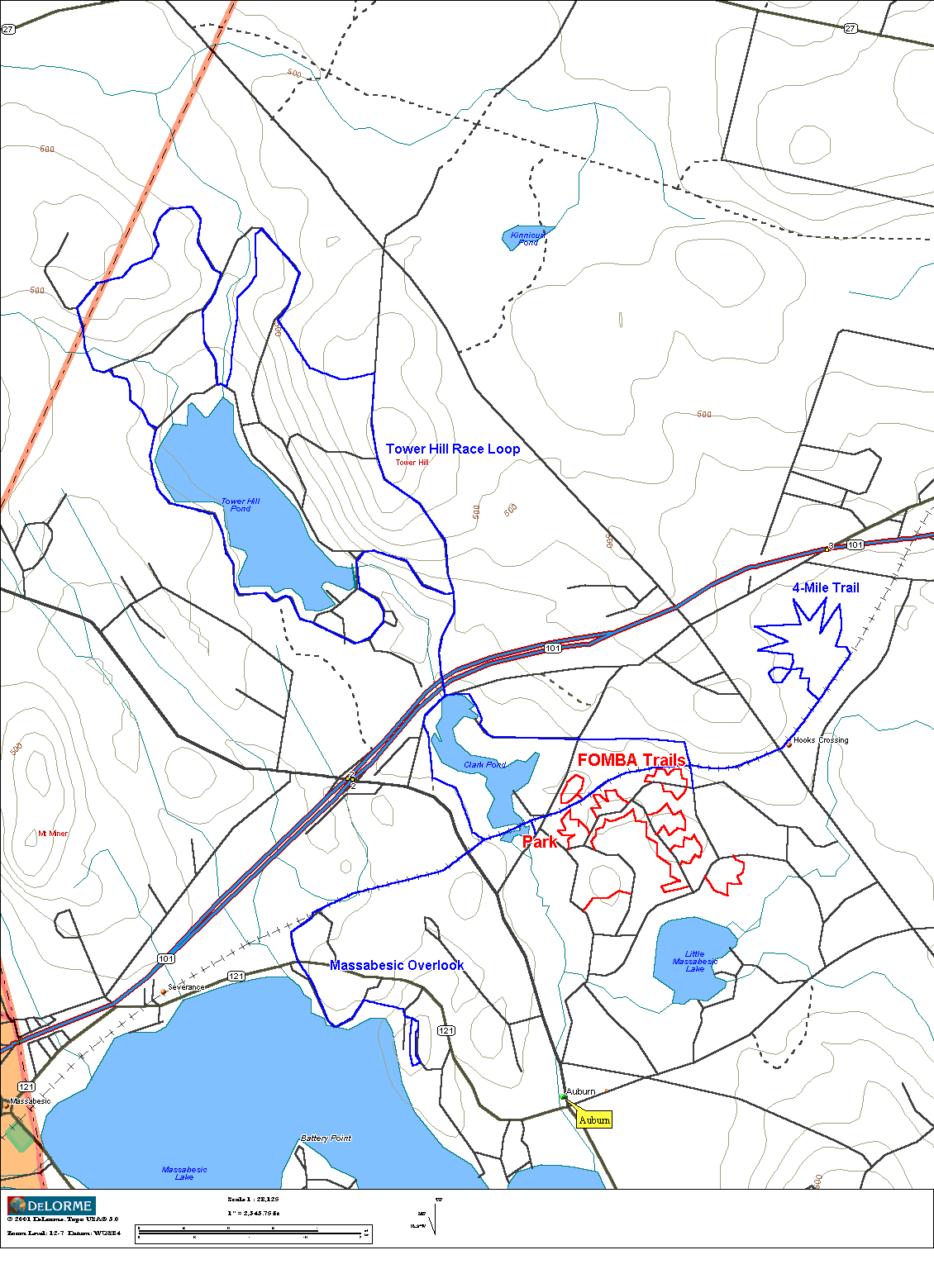
Friends of Massabesic Bicyling Association (FOMBA), Auburn, NH (map)
The FOMBA trail system and surrounding
network of other trails has grown to the point of making it a frequent
destination of mine. The FOMBA network itself consists of 10 singletrack
loops linked together with fire roads. Riding all 11 and counting loops
will produce at least a 12-15 mile ride. FOMBA singletrack is extremely
tight, twisty, rooty, and rocky in places. No climbs, and don't expect to
go too fast here. My average speeds hover around 9 mph. The trails
are aggressively maintained, some say too aggressively. Areas that become
quite challenging seem to get manicured before less skilled riders have a
chance to cut work-around trails. The rebuilt and extended Fireline trail has
many natural rock features built into it now. A few of them I do not dare
attempt.
When I visit FOMBA, I add in many miles of additional non-FOMBA riding.
First, I head north to Tower Hill, the site of the Watershed Wahoo Race
each spring. The loop around Tower Hill Pond from FOMBA is over 10 miles
of riding with one 400 and one 200 foot climb. I'll ride this to get my
anaerobic fix in, since much of the FOMBA riding is too tight to redline your
heartrate. Another direction I'll head off to is the rocky overlook on
the east side of Massabesic lake. This consists of about a five mile
out-and-back with a 100 foot climb to the top. The last couple hundred
yards is ledgy, bare granite and is very fun to ride. Great view looking
over the lake. Finally, the other trail I hit is a gem of a trail.
Not sure who built it or what land it is on, but this singletrack loop is
4 miles long, chock full of features. There's two modest ladder bridges,
one very narrow log bridge over water, one large see-saw
made from giant log, and several stone bridges through stream crossings.
This trail is more open than FOMBA trail, so one can go faster and harder
if one wishes. The trail head is about 1.5 miles east down the rail trail
from the Depot Rd parking area. Hard to follow at first, but then it's
all narrow singletrack. The loop dumps you out a quarter mile further
down the rail trail. [Note: As of late 2005, beaver dams and logging have
destroyed much of this trail. Not sure if it will come back to life.] Riding
all of the FOMBA trails, the Wahoo circuit, Massabesic overlook, and the
4-miler will produce a 30+ mile ride, close to what I would call an epic. My map highlights each of these areas. Latest FOMBA map
should be located here (pdf).
6. Beaver Brook Association, Hollis, NH (map,
website)
Beaver Brook is very close to my house and only minutes from Nashua, NH. Over 20 miles of pristine, technical single and double track. There are a
few short but steep climbs and plenty of rocks, roots, and narrow hewn log
bridges, lest you forget you’re in New Hampshire. There are also sections
that can be ridden fast for those who have a need for speed. Beaver Brook
stays reasonably dry in most areas during wet parts of the year. Beaver
Brook is a nature preserve and much of the singletrack is off-limits to
mountain biking, so ride responsibly. I’ve not had any run-ins with
hikers yet, unlike what riders experience in the Middlesex Fells. You can
spin over to Birch Hill (map) one mile by road for
a nearly 500 ft vertical climb up the service road to the communication
tower. The ATV trail decent down to Rocky Pond is a real hoot.
Couple of good rock launches. There are multiple ATV trails that lead to
the summit of Birch Hill. Experiment to find what you like. The
Beaver Brook/Birch Hill makes for a very interesting night ride.
7. Monarch Crest/Silver Creek/Rainbow Loop, Poncha Springs, CO (website, LBS)
Riding the Monarch Crest Trail in September 2006 tops my list of all-time
favorite trail riding experiences. The 403/401 loop not far away in Crested Butte comes in a very close second. The Crest loop has that “just right” magical mix of
climbing, ridgeline singletrack with killer views, and miles of the flowiest
descent imaginable. My friend Dave and I began this 54 mile loop by riding 18
miles up to Monarch pass on paved Rt 50. Easy grade, good views, a little
traffic, but makes that ridgeline ride all the more meaningful. Most “normal”
riders will hire a shuttle service from Salida to the pass and begin their ride
there. Contrary to what the website says, a shuttle is NOT required, as we’ve
demonstrated. Almost immediately after leaving the highway, we found ourselves
on pristine singletrack climbing some more until we leveled off around 12,000
feet on the Continental Divide. Views were incredible to either side. We
zigzagged along the divide several times over 10 miles to Marshall Pass. Marshall Pass sits a little lower than Monarch Pass, so there’s some descending along the way.
We continued south along the crest beyond Marshall Pass, tackling a fairly
respectable climb. More views popped up along the 5 miles to the Silver Creek
Trail, which began our descent back to town. Silver Creek was a blast. It
starts out with some full speed switchbacks which eventually stay deep in the
valley along the creek. Every now and then a meadow would open up just to let
you know how tall the mountains around you were getting as you sunk further
into the valley. High speed was carried continuously. We followed Silver
Creek until reaching the junction with the Rainbow Trail. Rainbow continues
the descent for another 10 miles on singletrack, but is no longer a monotonic
descent. It undulates something fiercely, forcing a couple dismounts on very
short but very steep pitches to scale. Most of the trail was buttery smooth
and followed the contour of the deeply corrugated landscape. You couldn’t take
your eyes off the trail for one second. The trail was maybe only 10 inches
wide in places with very steep drops to the left. While carving into banked
drainages, you would experience 2x or more G-forces. Likewise, when popping
out of drainages or divots, you would experience moments of weightlessness.
More fun than adults should be allowed to have! Eventually the trail dumps out
on Rt 285, and the ride and fun are almost over. Another 6 miles bombing down
smooth pavement brought us back to the car in Poncha Springs.
8. Trail 403/401 Loop, Crested Butte, CO (website)
Crested Butte was my all time top mountain biking experience when I visited in
September, 2005. I was so impressed with the riding here that I returned with
a friend in 2006 There are hundreds of miles of singletrack riding accessible
from Crested Butte, but many locals agree trails #403 and #401 form the best
loop. This ride begins right from town, gradually climbing on Washington Gulch Rd. This jeep road follows a highly scenic valley and progressively gets
steeper as the junction with Trail #403 is approached. Trail #403 climbs more
aggressively at first, leveling off as the pass between Mt Baldy and Gothic Mtn
is reached. The expansive views of valleys to either side will blow you away.
This is at an elevation of around 11,500 feet. Descending Trail #403 to Schofield Pass Rd is extreme. This was the steepest cascade of switchbacks I ever
attempted. A few were just too scary to even try. Lots of loose rock about
too. You are practically looking straight down on Schofield Pass Rd the whole
time you’re carving switchbacks. Once reaching Schofield Pass Rd, the ride
heads north and begins climbing again. Schofield Pass Rd is climbed for
several miles to Schofield Pass where the northern most junction with Trail
#401 is located. Trail #401 climbs first in trees, but then pops out into the
open. The trail is cut high above Schofield Pass Rd on the mountain range side
skirts. The view down the valley towards Mt Crested Butte is breathtaking and
is frequently photographed for magazines and calendars. This narrow ribbon of
singletrack has a nice downhill bias too it and goes on and on. You don’t even
seem to get any closer to the valley floor after descending for considerable
distance, and the view stays wide open the whole way. A series of fast switchbacks
drop back down to Gothic Rd in the valley below (Schofield Pass Rd turns into Gothic Rd). But a left at this junction with a bit of climbing brings you back into
singletrack bliss. This section is a little more wooded and can have some
color in the fall. Cows are also more prevalent here. This finally pops out
on a Jeep road that goes back down to reality at the base of Gothic Mtn on Gothic Rd. This dirt road is then bombed back to Crested Butte with more downhill along the
way to enjoy. This ride covers about 36 miles and entails over 5000ft of
climbing. The views will stay with you for a lifetime.
9.
Resurrection Pass/Devils Pass Loop, Seward, AK (website)
A cycling-centric family trip to Alaska in the summer of 2006 entailed riding
that rivaled Crested Butte riding. Even though Alaska is thousands of miles
from Colorado, some of the scenery is similar. While rides in Crested Butte
range from 9,000 to 12,000 feet, rides in Alaska range from sea level to 4,000
feet. The difference is Alaska is much further north. Generally, rising above
a couple thousand feet places you in alpine tundra – no trees, scrubby
vegetation, and expansive views. It is these qualities that make riding in
these two disparate locations so similar. The capstone ride of this trip was
the Resurrection Pass/Devils Pass loop near Seward. This ride runs about 50
miles with over 5000 feet of climbing, but does include some highway to get
back to the car. Parking in Cooper Landing, the ride is begun at the southern
terminus of the Resurrection Pass Trail. This singletrack climbs modestly much
of the time for almost 20 miles to Resurrection Pass. Streams are crossed,
waterfalls are passed, and lake shorelines are followed, all the while stunning
snow capped mountain peaks rise up around you. There are some steep climbing
sections, particularly the section after passing Swan Lake. But it isn’t long
after this the views really start to open up in tundra environment. Everything
was so green. This area reminded much of Trail #401 in Crested Butte. Upon
reaching the high point at Resurrection Pass (elevation 2600 feet), the loop
ride with Devils Pass Trail requires backtracking about two miles to begin the
descent down this trail. You could continue straight on Resurrection Pass
Trail for another 20 miles north to Hope, but then you would either need to
have a car spotted there or ride roads for 44+ miles back to the Cooper Landing
trailhead. I opted to come down Devils Pass, which descended to the east in a
deep “V” valley. The trail was bench cut into steep terrain and offered open
views much of the way down. The high speeds, carving in and out of streamlets,
tall vegetation all had me concerned I’d run into a bear... literally. Didn’t
see any bear on this ride, but did see lots of recent (fresh) evidence they
were around.
10.
Ape Canyon Trail, Mt Saint Helens, WA (website)
The Ape Canyon Trail on the flanks of Mt Saint Helens made such an impression
on me I had to ride it twice in the same trip. If I ever visit the Portland, Oregon area again, this ride will be on my must do list. I rode it as an out and
back, but it can be ridden as a large loop that I’ve read is hard to follow
unless somebody shows you the first time. The ride begins climbing on
singletrack along a huge chasm of a mud flow from the 1980 eruption. This mud
flow is actually minor compared the main flow that resulted when the whole
north side of Mt Saint Helens was blown away in the eruption. There are many
views along the way, including many huge old growth specimens that survived the
1980 blast. After gaining about 1200 feet, the Loowit trail is reached. This
is taken north through the Plains of Abraham where the grade flattens for a
while. The landscape here is surreal. It is devoid of vegetation as far as
you can see. The surface is mostly white pumice, but punctuated with huge
black volcanic boulders. Riding here can be tricky too. Most parts of the
singletrack ribbon are firm and fast, but once and a while the pumice is like
riding in six inch deep marbles. One needs to be especially careful when
dropping into the many washes along the way. Finally, the Truman Trail is taken across Windy Ridge. This too was fantastically fun to rip on. There are
no trees standing as far as you can see here, as everything was wiped clean in
1980. Simply amazing how all the dead trees lie on the ground in the same
direction. The ridge line comes to a fine cusp that was scary steep to either
side. No fear of death, but scary enough you didn’t want to gaze at the
postcard views while rolling. I turned around at the Windy Ridge terminus for
about 1500ft of singletrack descent back to the car. Views I missed while
climbing were captured on the return trip. Because you can get to Windy Ridge
with a car, many riders will shuttle this ride to avoid the climbing, but it
really is not that steep. It’s much easier to take in the views at slower
climbing speeds. If I have the opportunity to do this ride again, I will try
to make a loop ride out of it with the Smith Creek Trail.
11. Alpine Trail, Westfir, OR (website)
This ride is the venue for the famous annual Cream Puff 100 mountain bike race.
It is anything but a “Cream Puff.” The race does three 33 mile laps, each with
about 6000 feet of climbing. That’s 100 miles and 18,000 feet of climbing, and
it’s touted as the toughest 100 mile MTB race in the world. I rode the Cream
Puff 100 course in September 2004. The climb, 17 miles long and gaining 3600
feet, begins on 3 miles of pavement, then 14 miles of forest service roads in
good shape. Not steep at all, with one significant downhill on the way up. In
fact, single-speeders place in the top five on this course. The roads were poorly
marked up top, and with heavy overcast the day I rode, I had no sense of
bearings. I did eventually find the Alpine Trail trailhead without taking any
wrong turns. The trail is a narrow, smooth, brown ribbon of singletrack. It
first climbs a couple hundred feet over a small peak through magnificent old
growth forest before descending a little. Then a more aggressive several
hundred foot climb ensues to the summit of Sourgrass Mountain. The mountain is
covered in a unique grass, presumably sourgrass, but no view the day I rode due
to cloud cover. The trail then rolls up and down around 4000 feet elevation
for several miles. Wicked fun stuff. Finally the descent begins in earnest,
at times very steep with switchbacks. Views opened up along the way. When I
thought I was getting close to the bottom, another view would open up, still
way above Westfir. Some more rolling benchcut singletrack is followed before
steep descending resumes. Portions of the final descent were extremely fast
and smooth. Couldn’t help but wear ear to ear grin coming down this stuff.
Finally the covered bridge in Westfir pops into view and I knew the ride was
about over. A great loop, one I will do again if visiting Oregon. What I
liked most about this ride was the remoteness of it, the lush, green old growth
forest, and about 16 miles of continuous singletrack descent. There are many
other trails in this area I’ve yet to explore.
12.
Gridley-Pratt Loop, Ojai, CA (website)
This is perhaps my favorite ride in SoCal. In three visits I have ridden
it twice. Even though there are so many places yet to explore, this ride was
so good the first time I did it that I had to do it again. I start right from
the national forest ranger station in town. Gridley Trail starts as a
double-track on the edge of town, winding through orange groves. The
first little bit is very steep, then the grade moderates. As the climb
continues, the trail gets narrower and narrower, until it becomes a ribbon of
singletrack. The entire trail is benchcut into extremely steep pitches,
but rises at a surprisingly moderate rate. There are many areas that are
very scary to look down, almost looking straight down your outside leg at the
singletrack you were on minutes ago hundreds of feet below. Shaly rock
slides also fill the trail in places, leaving nasty off-camber, loose surfaces
to ride on. If you washed out on some of those, nobody would ever find
you again! From town, Gridley gains about 3750 feet in 10 miles of
continuous climbing to the summit of Nordhoff Peak. The views are
incredible as you switchback many, many times working up steep canyons to the
top. From the top, Pratt Trail is taken back to town. This descent
is very similar to the climb: moderately steep grades, near shear drop-offs to
side of trail, and hair-pin switch-backs. Really need disk brakes for
this kind of riding. Not sure if a set of rim pads would hold up whole
way down. The full loop ran about 17 miles.
