Top Ten Trails List
Top 10 Favorite Rides: First Five Within One
Hour from Home, Second Five from Around the Country.
1.
Bear Brook State Park, Allenstown, NH (map)
I rate Bear
Brook number one because I ride it regularly and never get bored with
it. Bear Brook provides 10,000 acres with miles and miles of singletrack.
My favorite loop starts out from the parking on Podunk Road just off Deerfield Road. Start on
singletrack Pitch Pine Trail, picking up Broken Bolder Trail at Campground Road,
then Podunk Road
to Hall Mountain Trail. The final assent up Hall Mountain
will put a good burn in your legs. Coming back down the same way on Hall
Mountain Trail, unmarked singletrack is picked up at Podunk Road. This begins the
technical portion of the ride. The singletrack will eventually dump you
out near the intersection of Podunk
Road and Bear
Hill Road, but not before taking you over numerous
rock formations, drops, and tight twisty sections. Ferret Trail is taken
to pick up Hedgehog Ledge Trail. Enjoy the view from the point out into
Bear Hill Pond first. Hedgehog Ledge Trail is taken back to Podunk Road.
Watch out for the granite stair case! At the parking lot at the bottom of
the hill, Carr Ridge Trail with some very challenging single track descents is
taken. Where Carr Ridge meets Cascade, a decision must be made: Head back
to the parking lot along Bear
Brook Trail,
or if you are up for some real punishment, take Cascade Trail up to Catamount
Trail. There are nice views from peaks that Catamount services, but the
climbs and descents will challenge even the most skilled riders. I
usually take Lane
Trail (two-track) back to
Podunk Road,
Podunk up to Chipmunk Trail. Chipmunk is then taken back down to
Podunk, doubling back slightly to pick up Little Bear Trail. Little
Bear is mostly downhill singletrack back to the parking area and can be ridden
scary fast. This loop runs about 22 miles and 2 - 3 hours, depending on
skill/fitness level. I recommend obtaining a map with your summer access
fee, but I have posted a marked up map of “my
ride” (240kB JPEG) here for your convenience.
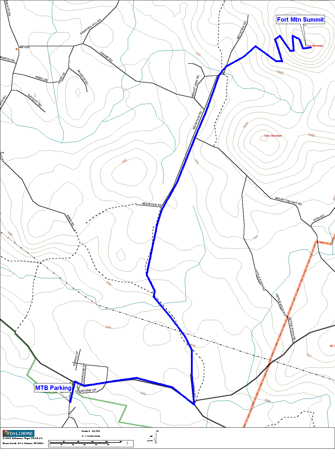
Lately, I’ve been adding some additional climbing outside of Bear Brook
to my ride. Fort
Mountain (map) looms over Bear Brook to the Northeast. It
has a summit of 1400 feet, giving an elevation gain of about 1100 feet from the
parking area on Podunk Road.
I take Deerfield Road
to Mount Delight Road,
but immediately after turning left onto Mt. Delight,
bear left onto dead-end residential street. Take this straight off end
onto jeep road. A mile or so down, take right onto jeep road just after
large rocks on right. After about 0.7 miles of jeep road, continue
straight on dirt road. About 0.6 miles of dirt road takes you to paved
road. After only short distance on pavement, go straight off end of
pavement (don’t follow pavement to left) onto another jeep road. In
a quarter mile, you’ll see pavement again, but bear right to stay on
gravel surface. Once you see heavy-duty power lines, follow them.
They go up the service road to the communication tower on top of Fort Mountain.
This begins the serious climbing. I usually can’t hold 5 mph
all the way up. Very steep, switch-backed, loose gravel climb, gaining
several hundred feet in a fraction of a mile. The view at the top is
worth it, offering unobstructed views over 360 degrees. The ride back to
Bear Brook is a real hoot. My brake rotors reach “sizzle
spit” hot at bottom of service road. Altogether it’s about 10
miles out and back.
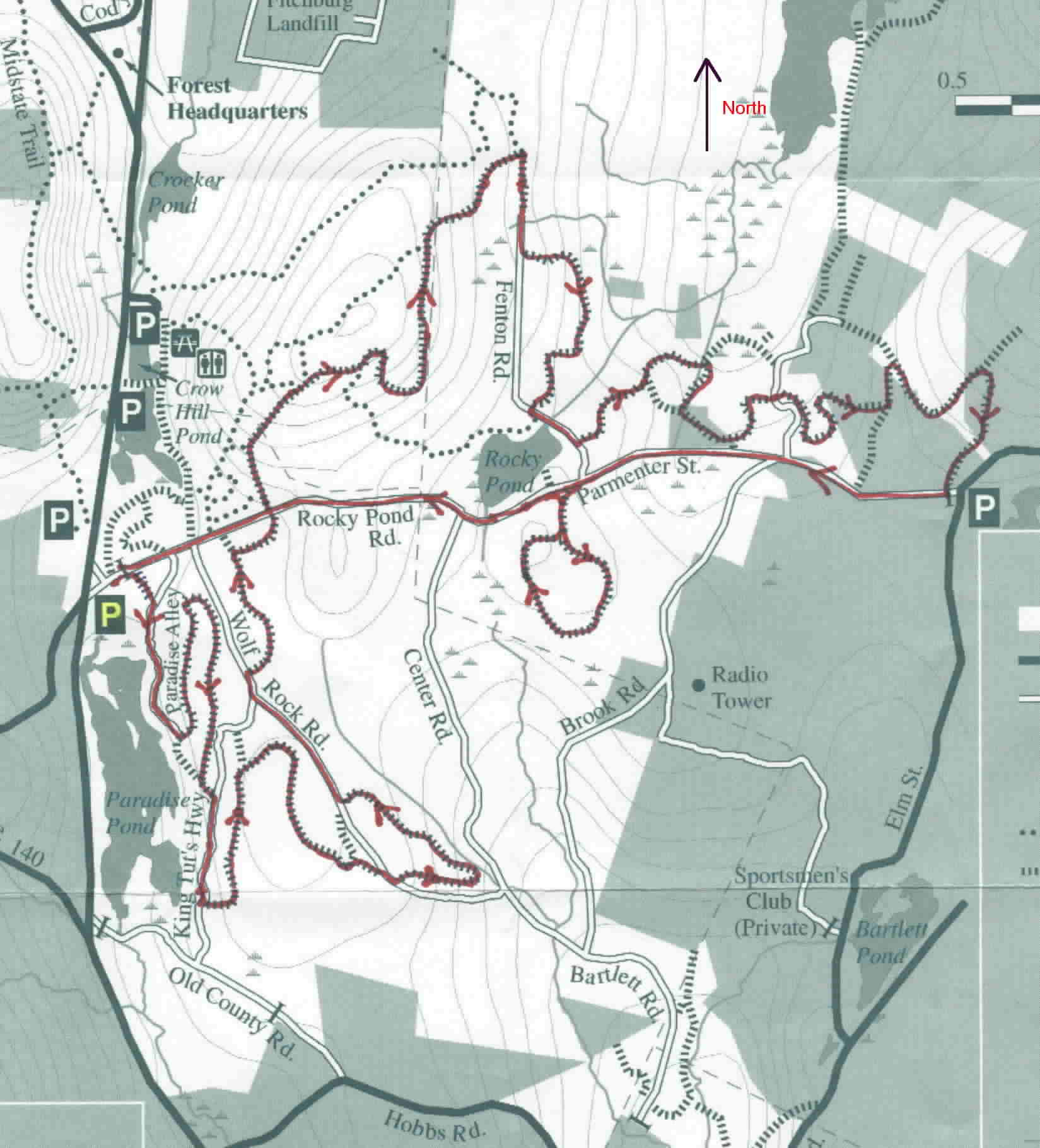
2. Leominster
State Forest,
Westminster, MA
(map)
Leominster is
quickly becoming my second most ridden state forest or park. Leominster is 4100 acres
in size, and has many miles of technical singletrack. I usually park at Rocky Pond Rd on Rt
31. This gives good access to nearby 2000 foot “Wa Wa
Wachusett” Mountain for a good warm-up climb. To climb Wachusett by
road, take Rocky Pond Rd
across Rt. 31 and Rt 140. Rocky Pond becomes Mirick Rd on the other side of Rt
140. Watch for Pine Hill Rd
on the right. Take Pine Hill up to Mountain Rd, then a quick right/left into
the Wachusett auto road entrance. From Rocky Pond parking lot to summit
is approximately 1000 ft elevation gain in just under 5 miles. Enjoy the
view! Round trip is about 9 miles (shorter, steeper one-way auto road is
taken down). Take same way back to begin off-road ride. Since most
of the trails in Leominster State Forest (LSF) are not named or color blazed,
it is difficult to describe my loop. That’s why I include a map of “my ride” (134kB JPEG).
LSF is one of the rockier places I ride, so I usually bring my full-suspension
bike. No fear of death stuff here, but the numerous rock gardens will
frustrate even seasoned riders. Plenty of climbing is available
also. Referring to the map, I usually start in the area of King
Tut’s Hwy and Wolf Rock Rd.
All singletrack, all rocky. Then I cross over Rocky Pond Rd for a good climb, the
biggest in LSF. This links up with the end of Fenton Rd, where another recently
NEMBA-built loop of singletrack is taken. Sweet stuff. Some more
singletrack is picked up off Fenton
Rd. This NEMBA trail is less rocky, nicely
bermed, and can be taken very fast. On the way back to the parking lot, a
small loop of singletrack is taken on the left side of Parmenter St. The complete ride,
including the Wachusett climb, runs about 24 miles and 2.5 to 3.5 hours.
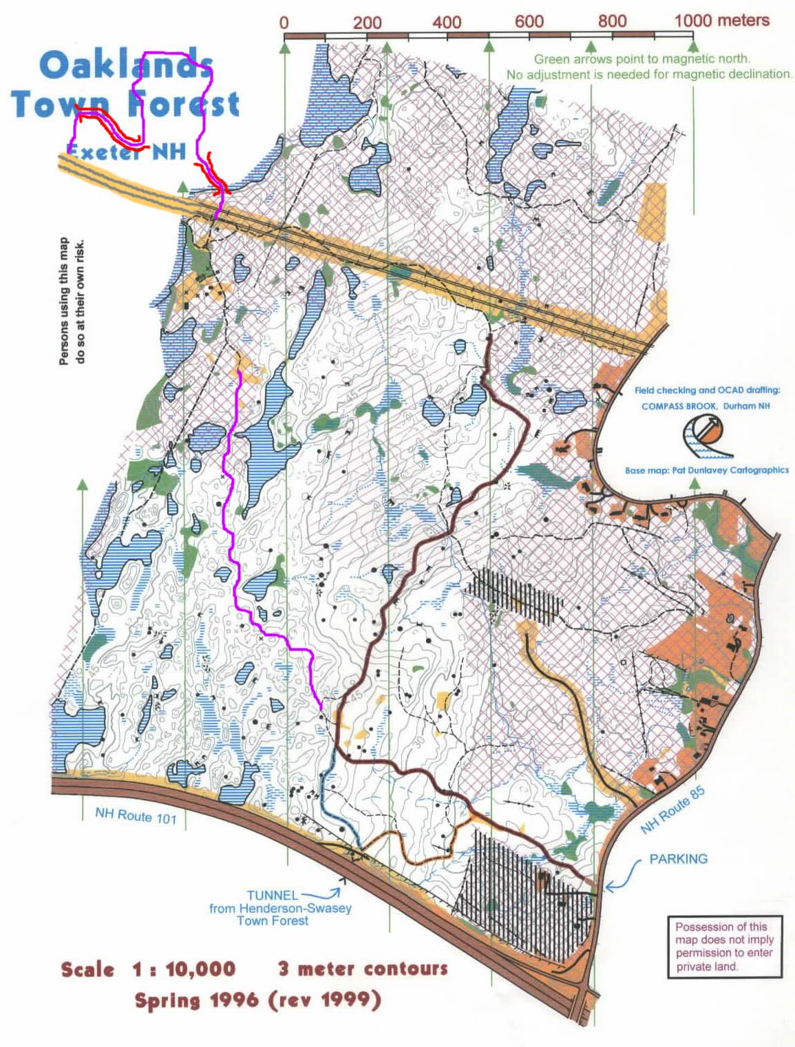
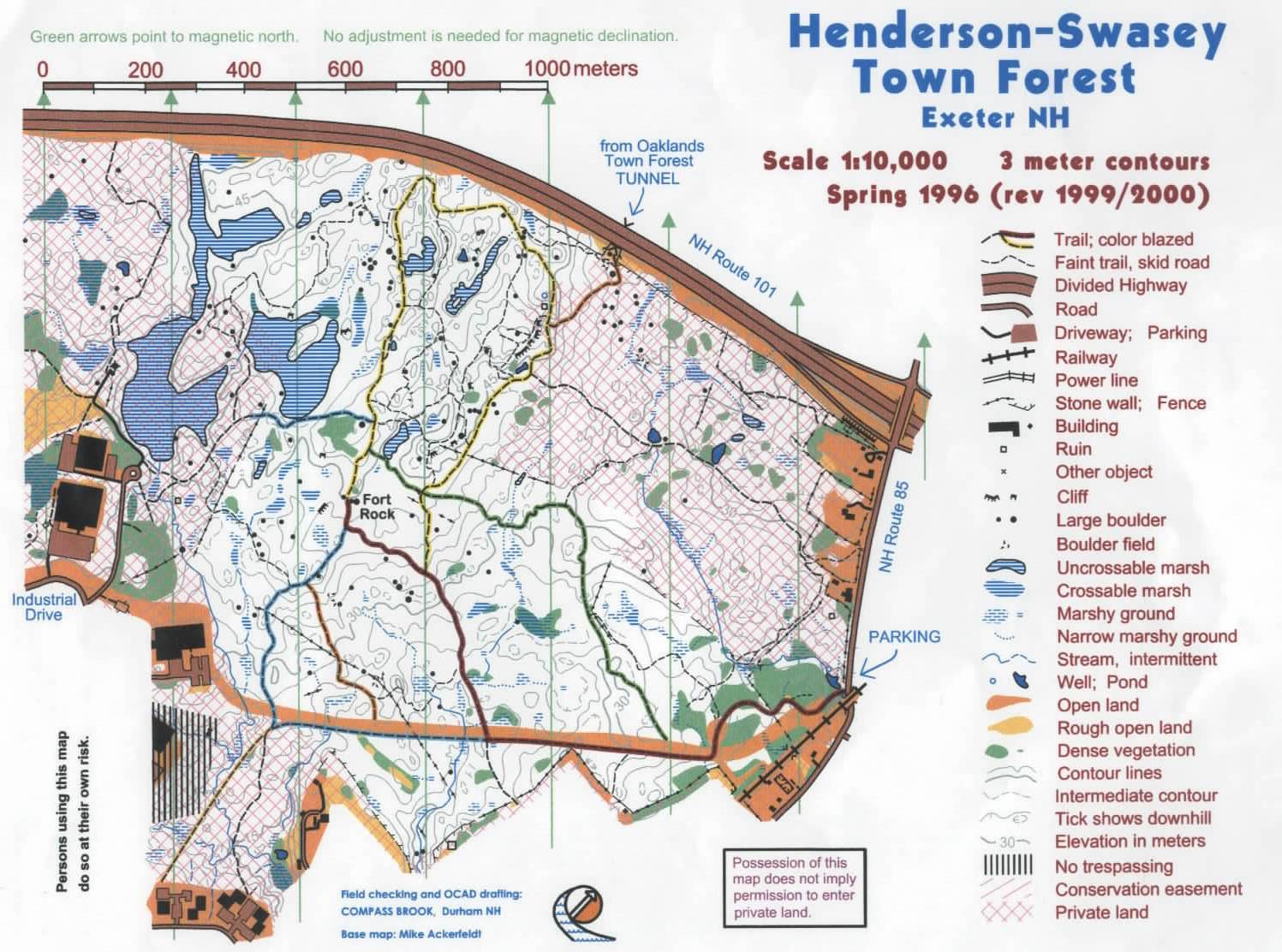
3. Fort
Rock (Oaklands/Henderson-Swasey Town
Forests), Exeter, NH
(Oaklands Map) (Henderson Map)
Fort Rock
is becoming a popular destination for riders from Maine,
New Hampshire, and Massachusetts. Its location not far
from the coast makes it very accessible. The Town of Exeter has been very receptive to proposals
from the mountain biking community, and many new trails and bridges have been
built recently. The divided highway, Rt 101, splits Fort Rock
in half. A tunnel below the highway joins the two halves. The
Oaklands half, north of Rt 101, is the largest and has the most miles of
trails. There are lengthy sections of new singletrack that don't show on
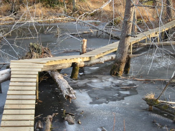
the town forest maps. One trail contains two bridges, one that has a
peaked, dog-legged section in the middle several feet above swamp water (photo). Very intimidating when I
first encountered it. Last winter there was a large hole in the ice where
somebody went off the narrow bridge, dropped several feet to the ice and
crashed through! The other bridge is about 300 feet long, a few feet
above wetlands, and is flat with gentle turns in it (photo). Both bridges are well built
with pressure treated lumber. There are numerous other bridges consisting
of ladder, log, rock, and lumber construction types. The town land
adjoins other private unposted land with many miles of single- and double-track
trails with a few climbs. The Henderson-Swasey half, south of Rt 101, is
smaller in size, but has a very high density of singletrack trails. Some
are quite technical, with a large boulder playground area in the center.
I once saw a large contingent of trials riders in there filming 8-foot
drops off large rocks. Nearly all the trails on this side show on the
town forest map and are color blazed.
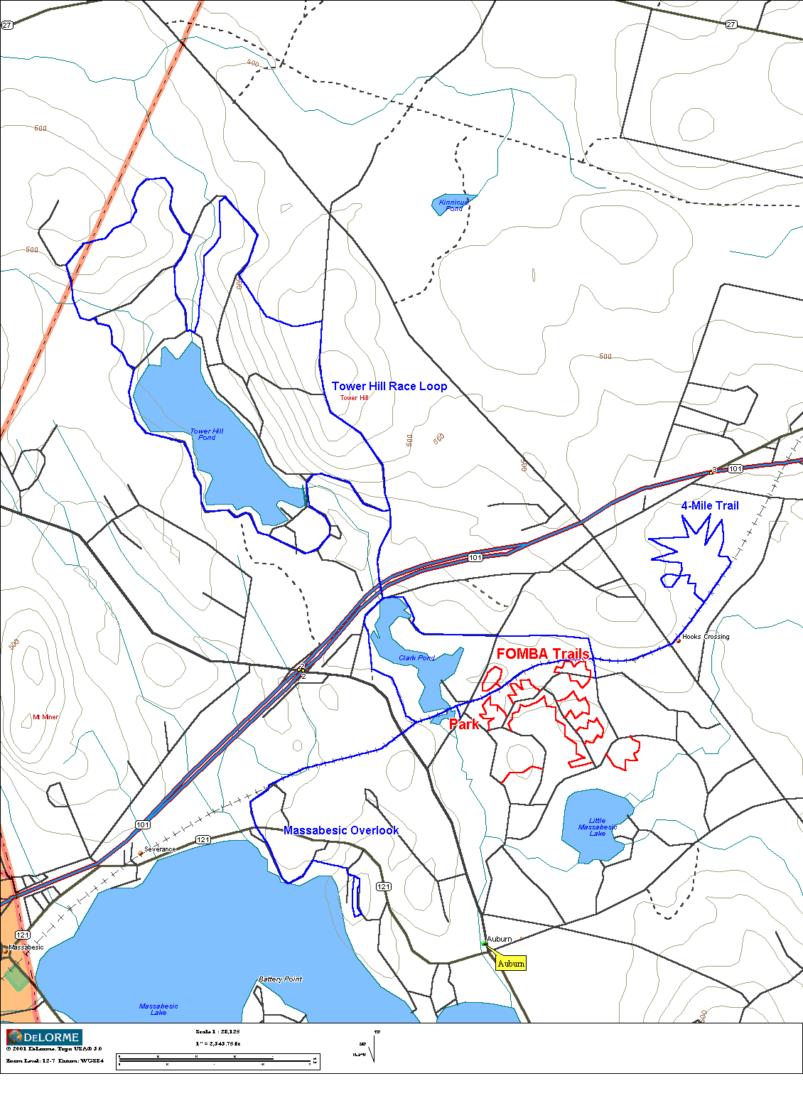
4. Friends of Massabesic Bicyling Association
(FOMBA), Auburn, NH (map)
The FOMBA trail system and surrounding
network of other trails has grown to the point of making it a frequent
destination of mine. The FOMBA network itself consists of 10 singletrack
loops linked together with fire roads. Riding all 10 loops will produce
at least a 12 mile ride. FOMBA singletrack is extremely tight, twisty,
rooty, and rocky in places. No climbs, and don't expect to go too fast
here. My average speeds hoover around 9 mph. The trails are
aggressively maintained, some say too aggressively. Areas that become
quite challenging seem to get manicured before less skilled riders have a
chance to cut work-around trails.
When I visit FOMBA, I add in many miles of additional non-FOMBA riding.
First, I head north to Tower Hill, the site of the Watershed Wahoo Race
each spring. The loop around Tower Hill Pond from FOMBA is over 10 miles
of riding with one 400 and one 200 foot climb. I'll ride this to get my
anaerobic fix in, since much of the FOMBA riding is too tight to redline your
heartrate. Another direction I'll head off to is the rocky overlook on
the east side of Massabesic lake. This consists of about a five mile
out-and-back with a 100 foot climb to the top. The last couple hundred
yards is ledgy, bare granite and is very fun to ride. Great view looking
over the lake. Finally, the other trail I hit is a gem of a trail.
Not sure who built it or what land it is on, but this singletrack loop is
4 miles long, chock full of features. There's two modest ladder bridges,
one very narrow log bridge over water, one large see-saw
made from giant log, and several stone bridges through stream crossings.
This trail is more open than FOMBA trail, so one can go faster and harder
if one wishes. The trail head is about 1.5 miles east down the rail trail
from the Depot Rd
parking area. Hard to follow at first, but then it's all narrow
singletrack. The loop dumps you out a quarter mile further down the rail
trail. Riding all of the FOMBA trails, the Wahoo circuit, Massabesic
overlook, and the 4-miler will produce a 30+ mile ride, close to what I would
call an epic. My map highlights each of these areas.
5. Beaver Brook Association, Hollis,
NH (Map)
Beaver Brook is very close to
my house and only minutes from Nashua,
NH. Over 20 miles of pristine,
technical single and double track. There are a few short but steep climbs
and plenty of rocks, roots, and narrow hewn log bridges, lest you forget
you’re in New Hampshire.
There are also sections that can be ridden fast for those who have a need for
speed. Beaver Brook stays reasonably dry in most areas during wet parts
of the year. Beaver Brook is a nature preserve and much of the
singletrack is off-limits to mountain biking, so ride responsibly.
I’ve not had any run-ins with hikers yet, unlike what riders experience
in the Middlesex Fells. You can spin over to Birch Hill (map) one mile by road for a nearly 500 ft vertical
climb up the service road to the communication tower. The ATV trail
decent down to Rocky Pond is a real hoot. Couple of good rock
launches. There are multiple ATV trails that lead to the summit of Birch
Hill. Experiment to find what you like. The Beaver Brook/Birch Hill
makes for a very interesting night ride.
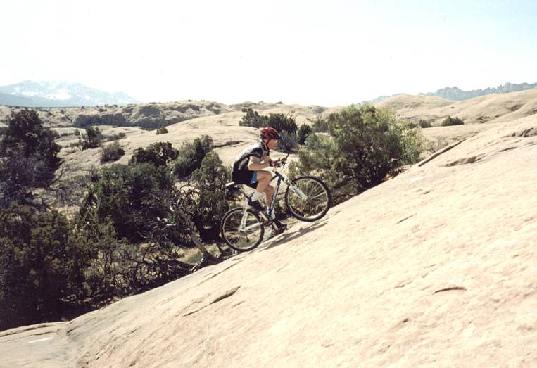
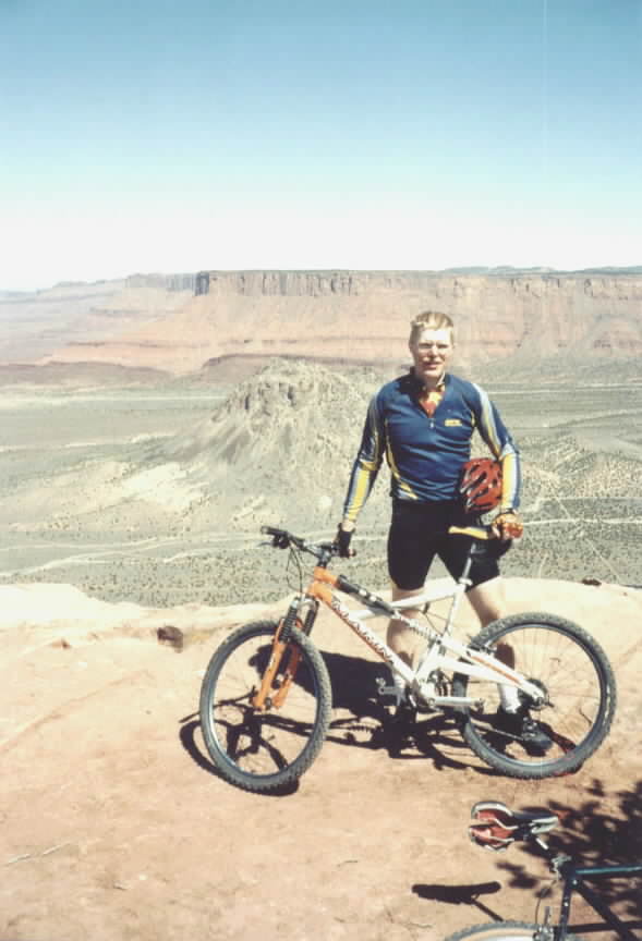
6. Slickrock Trail,
Moab, UT
Moab was perhaps the best mountain bike
experience I’ve had to date. I’d rate it number one except
it’s not a place I can visit any day since I live in the NE. The
Slickrock trail is considered the world’s most popular MTB trail.
When first beginning the 12 mile loop, the climbs and descents can be a bit
unnerving. But slickrock is equivalent to 80 grit sandpaper. Rubber
tires stick like glue, allowing riders to climb incredibly steep grades (if you have the legs for it) and ride
extreme off-camber grades. Once one adapts to the incredible traction,
much fun can be had. Some of the drops are so steep you don’t want
to think about touching your brakes. Almost all run-outs are gradual, and
speed that is quickly gained on the descent slings you up the opposing slope
— like a roller coaster on a mountain bike! I did part with some skin
on the Slickrock Trail. The traction temps one to climb grades beyond
one’s skill or power. When you Peter out and have to put a foot
down, surprise, hard soles and metal cleats offer little traction. You
and your bike are going for a slide.
Other trails I rode in Moab
are the Porcupine Rim trail (another must-ride!)
and the Moab Rim trail. Most people shuttle Porcupine Rim, starting
around 6000 feet, climbing to 7000 feet, then 3000 feet of descending over many
miles into the Colorado River gorge.
There are a few scary no-fall zones. The Moab Rim trail climbs at
about a 20% grade for a mile, gaining 1000 feet, on bare rock. Brutal on
your legs. Nice view of Moab
from rim.
7. Tucson
Mountain Park,
Tucson, AZ
Tucson
Mountain Park is rated seven (2nd for away from home trails) for
uniqueness. Located just west of the city, this park provides an endless
supply of single track from easy to sick. You ride through the diverse desert
environment Tucson
is famous for. In one ride I saw small lizards, deer, rabbits, coyote,
and road runners, more wildlife than I see in a week’s worth of riding in
the northeast. My favorite trails were Yetman, Star
Pass, and Golden
Gate. After my first ride in the Tucson Mountain
Park, I realized that
everything that grows out there has thorns on it. You DON’T want to
crash. If the thorns don’t get you, the jagged rocks will.
There’s lots of climbing available in the park with nice views to make it
worth while. Pick up a copy of “The Map” from any bike shop
in Tucson.
I got my copy and rental from Sabino Cycles.
8. Gridley-Pratt Loop, Ojai, CA
This ride was perhaps my favorite when I spent a week in SoCal. I started
right from the national forest ranger station in town. Gridley Trail
starts as a double-track on the edge of town, winding through orange groves.
The first little bit is very steep, then the grade moderates. As
the climb continues, the trail gets narrower and narrower, until it becomes a
ribbon of singletrack. The entire trail is benchcut into extremely steep
pitches, but rises at a surprisingly moderate rate. There are many areas
that are very scary to look down, almost looking stray down your outside leg at
the singletrack you were on minutes ago hundreds of feet below. Shaly
rock slides also fill the trail in places, leaving nasty off-camber, loose
surfaces to ride on. If you washed out on some of those, nobody would
ever find you again! Gridley gains about 3750 feet in 10 miles of
continuous climbing to the summit of Nordhoff
Peak. The views are
incredible as you switchback many, many times working up steep canyons to the
top. From the top, Pratt Trail is taken back to town. This descent
is very similar to the climb: moderately steep grades, near shear drop-offs to
side of trail, and hair-pin switch-backs. Really need disk brakes for
this kind of riding. Not sure if a set of rim pads would hold up whole
way down. The full loop ran about 17 miles.
9. Tsali Recreational Area, NC
The Tsali Recreational Area consists of four single track loops shared by
hikers, equestrians, and mountain bikers. The 35 miles of trail are
generally fast and hard packed, well maintained, with moderate elevation
gains. The area lies directly across Fontana
Lake from the Great Smokey
Mountains National
Park. The scenery is unbeatable, with many
vistas overlooking the lake. As evidenced by the diversity of license
plates in the parking lot, Tsali is definitely a mecca for mountain bikers in
the east. Visit
Nantahala Outdoor Center for pics and info. Doug as newbie mountain biker in 1996 at 230 lbs.
10. Sunday
River Ski Area, Bethel, ME
Sunday River, an eight mountain peak
ski area, is a real treat for the cross country rider. All of the peaks
can be reached on service roads or “green” ski trails. If
you like to climb, this is the place. Several of the peaks offer
panoramic views of the White Mountains, including Mount
Washington. Since the lifts in the summer bring the
down-hillers only half way up, the XC rider has all of the upper mountains to
him or her self. Two of the three times I visited Sunday River,
I never encountered another person at the summits. Across the summits of
Barker, Locke, and White
Cap Mountains,
there is some awesome single track. Most of the single track is at the
lower elevations serviced by lifts 2 and 6 and will test your wits. The
trail called Backside is a fast, steep, slick rock route down from North Peak.
If you are looking for a mountain top “religious” experience, this
is the place.