|
Comparison of NE Hillclimb Races
Here you will find information on hillclimb races. Only mountains that have been raced in the last few years are presented, primarily from the New England states plus eastern New York and New Jersey. The information presented makes it easy for those contemplating a race to compare the relative difficulty of each race. Some of these hillclimb events are not pure hillclimbs, in that there may be rolling or flat sections leading to the climb. The race profiles are depicted here, where only the climbing portion may be depicted elsewhere on northeastcycling.com. A 10% reference grade line is included in the graph as a cue in establishing relative steepness. Not many climbs exceed an average grade of 10%, but most will have sections approaching or exceeding this. The table below gives stats on the climbs. I’ve done my best to accurately show male and female records by manually going through all of previous year’s results I’m aware of. If I missed somebody, please let me know via the contact link above. Links to additional info are provided with each climb description, but these frequently change. Most perusers of the web know by now if a link does not work, try the root domain next, and if that fails, go to Google. Also, online registration for most of these climbs is offered at Bikereg once the season gets under way. Northeast Hillclimb Race Stats |
| ||||||||||||||||||||||||||||||||||||||||||||||||||||||||||||||||||||||||||||||||||||||||||||||||||||||||||||||||||||||||||||||||||||||||||||||||||||||||||||||||||||||||||||||||||||||||||||||||
|
Climbing Challenge: 5 = Very tough, most riders requiring special gearing 1 = A respectable climb, any fit rider can conquer without stopping or special gearing Descent Quality: 5 = Whoa baby, who needs brakes, fear of death!! In other words, nice, but be careful. 4 = Few turns/stops/traffic 3 = Tight switchbacks, frost heaves, rim cool-downs may be required 2 = Frost heaves, cracked pavement, getting pretty scary 1 = Severe frost heaves and/or loose broken pavement, can't wait to get to bottom 0 = Riding down is not permitted Remarks: 1. Not all climbs reach the highest point of the mountain. 2. Claimed, maybe on inside of steepest switchback 3. Excluding flat portion of race, 4mi climb averages nearly 11% grade 4. New 2012 course adds 3mi of downhill before 3500ft climb. Old course records were 42:40 Dan Cassidy 6/16/07, 49:42 Sue Schlatter 6/20/09, 48:17 PB 6/20/09 |
|
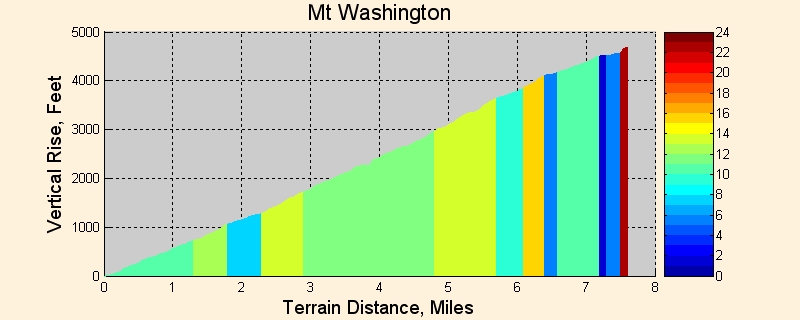
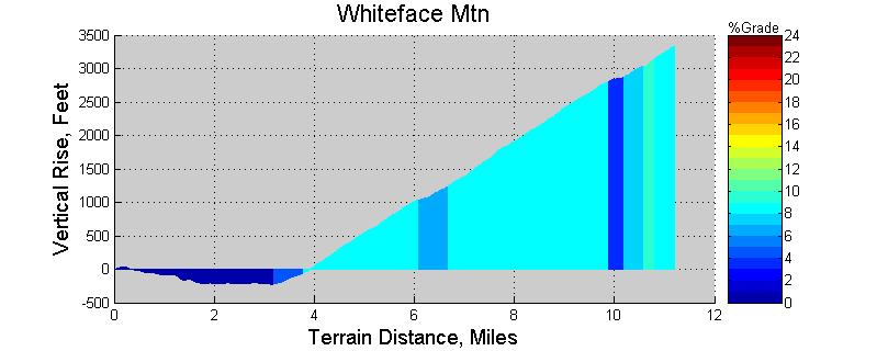
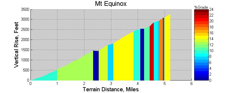
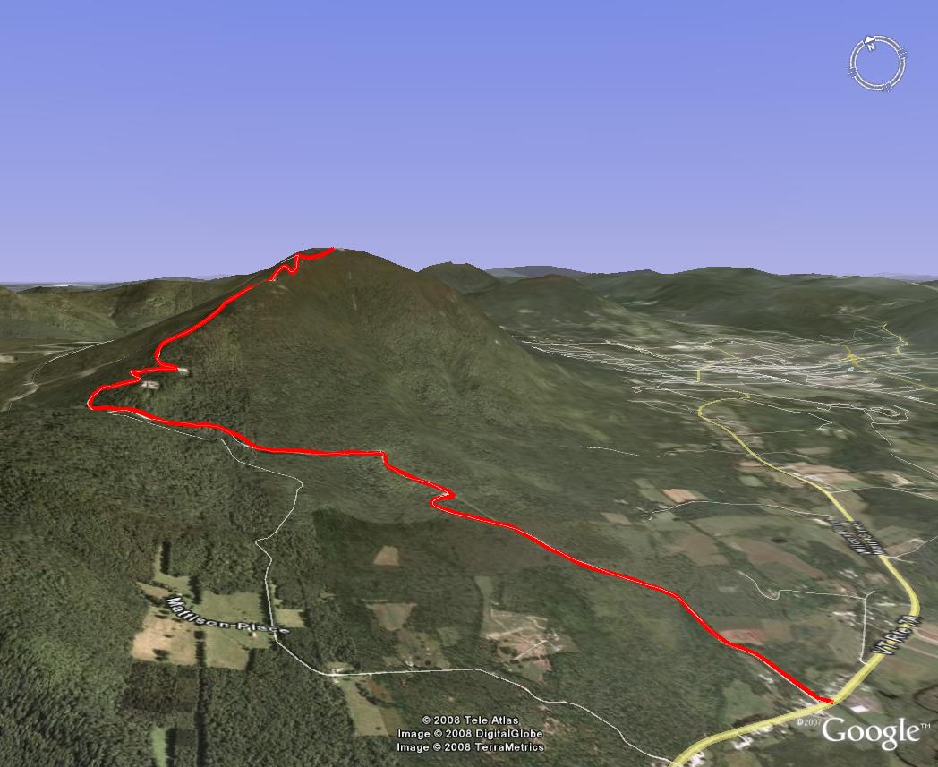
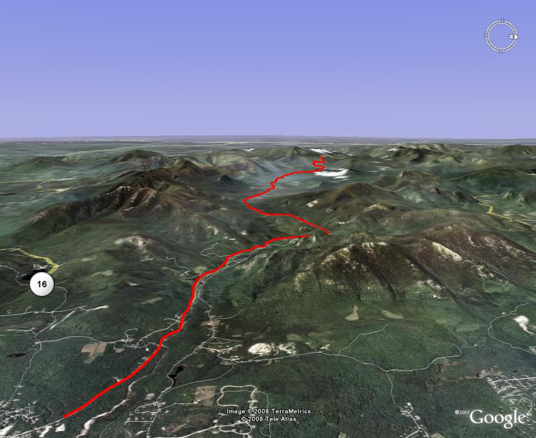
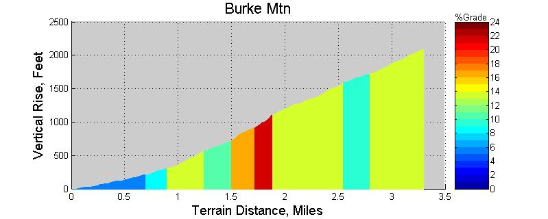
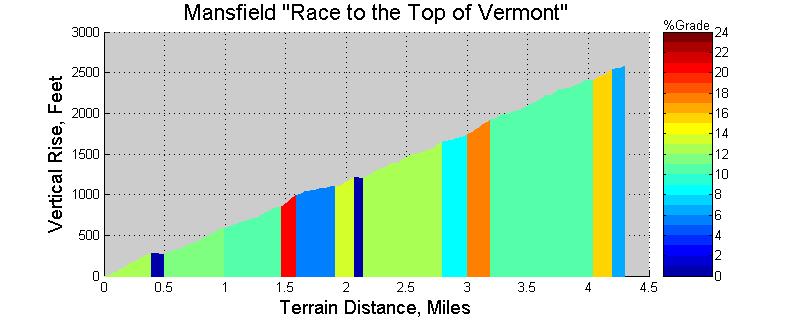
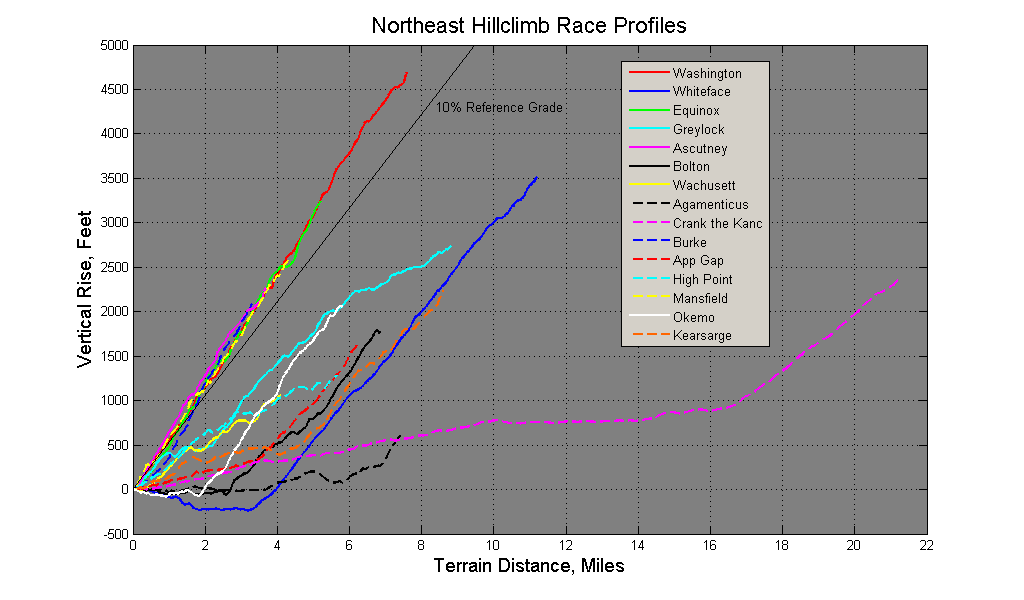
Northeast Race Hillclimb Details Each of the hillclimb races profiled above are presented in much more detail below. A detailed profile with color coded gradient is given. Photos and 3d imagery are provided on a few of the climbs also. Each climb is presented with the same gradient scale so climbs can easily be compared. Dark blue is less than 1% grade (including downhill), and dark red is 24% grade on each profile. Green, which is scale center, is 12% grade. A climb that has mostly blue color is probably less than 8% average grade. A climb with lots of greens and yellows likely averages around 12% grade. Climbs with oranges or a bit of red have exceedingly steep sections, such as the last bit on Mt Washington. Note that for each color-coded section of climb, that color represents the average grade for that section. Within the section, there may be less steep or steeper parts. An effort was made to pick meaningful points in which to break up climbs. This was a subjective process, and other eyes may see the climbs differently. The gradients should not be scrutinized too closely. DeLorme Topo 6.0 software was used to create most of the profiles. This software is known to be very inaccurate where roads traverse steep grades. Newer plots were created with Topo 7.0, and some improvements have been noticed. Large errors were manually corrected. Many small errors are still present in the profiles. These errors typically manifest themselves as small down hills where none exist, or a blip that looks really steep when in reality the grade remains constant in that section. If you find your GPS or HRM based altimeter gives slightly different shape to the profile, your measurement is probably correct. The profiles presented here should be plenty accurate for comparing racing climbs. Following individual color profiles of select climbs, a Google Earth rendition of the route is given. Vertical exaggeration was set to 1.5 for most plots to keep them uniform for comparison purposes. Distance scale factors vary, however. Exaggeration can be set as high as 3x, but this looks completely unrealistic. Let's first take a closer look at the "12-percenters," which include Washington, Burke, Equinox, Mansfield and Ascutney. Burke (Blue) starts out the most gradual, and as a mass start race, it pays to draft here. But after a mile or so, the grade kicks up with a vengeance and more than makes up for any lost ground against the other climbs in short order. Ascutney (Magenta) on the other hand, starts out steeper than the rest and stays that way for the first 2+ miles. Ascutney causes more pain and suffering than some of the much bigger climbs because of this. Mansfield (Yellow) undulates more than the others with a dirt surface. The most consistent climb is the biggest, Mt Washington (Red). Equinox (Green) very closely follows Washington, but it does have a dip in the climb at about 2.5 miles. Washington has no dips. All five of these climbs finish out at very nearly 12% average grade. 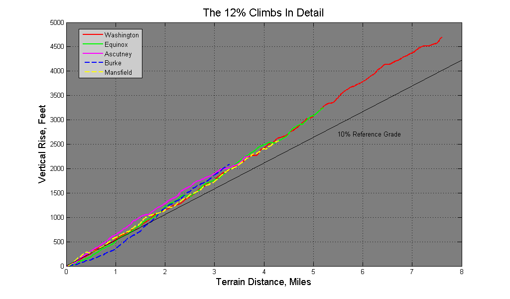
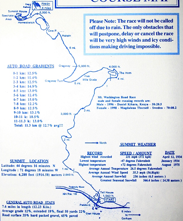
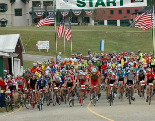
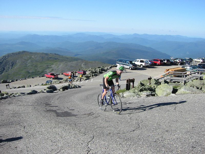
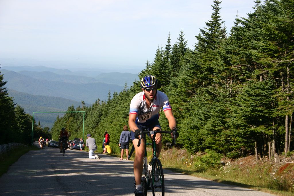
Mount Washington, NH Mt. Washington is the biggest climb in the NE, and often dubbed the toughest hillclimb in North America or even the world. I would not challenge the notion it’s the toughest road climb in North America, and foul weather most of the time plays a big factor in this. It is the grand-daddy of hillclimbs in the northeastern part of the country, and careers have been launched with wins on this mountain. In 1997, Tyler Hamilton broke a 17 year old record, and then in 1999, broke his own record again. A new kid on the block came along in 2002, Tom Danielson, and took another minute off Tyler’s fastest time. See this autoroad link for a history of records on Mt Washington. The mostly paved auto road rises 4727 feet in 7.6 miles, nearly a 12% average grade. There is a 22% grade section at the top! This climb is truly monotonically rising, no flat or downhill sections to catch your breath on the way up. There is a lengthy section of well groomed gravel that has not been a problem for my 23mm tires at all, but can get soft in rain. Bicycles are allowed on this privately owned auto road up to four times a year currently. These are the July and August races and their respective practice climb days. Riders must take auto transportation down. Weather at the top can be downright nasty, even mid-summer. One year when I did the climb in August it was in the 60’s at the base, but 39 and extremely windy at the top, and it snowed that night! There have been times when the race was cancelled. Mt Washington is also home to some of the worse weather on Earth. Until recently, the highest non-tornadic wind speed ever recorded on Earth was at the summit of Mt Washington at 231mph. Hurricane force winds are present 100 days a year on average. This in part makes Mt Washington one of the toughest bicycle climbs in the world. Due to great demand for this bicycle hillclimb, two races are held each year. The traditional Mt Washington Auto Road Bicycle Hillclimb is held in August. Since 2006, a second race called Newton’s Revenge has been held in July. The races benefit different causes and are independent of each other. Both races are held on Saturday mornings, with Sunday available for backup. Both races also offer unsupported practice climbs approximately one month before the race. Both races also have catered awards banquets after the race. Registration opens for Newton's Revenge only after the August race fills. Here's more information on the Newton's Revenge and August MWARBH races.
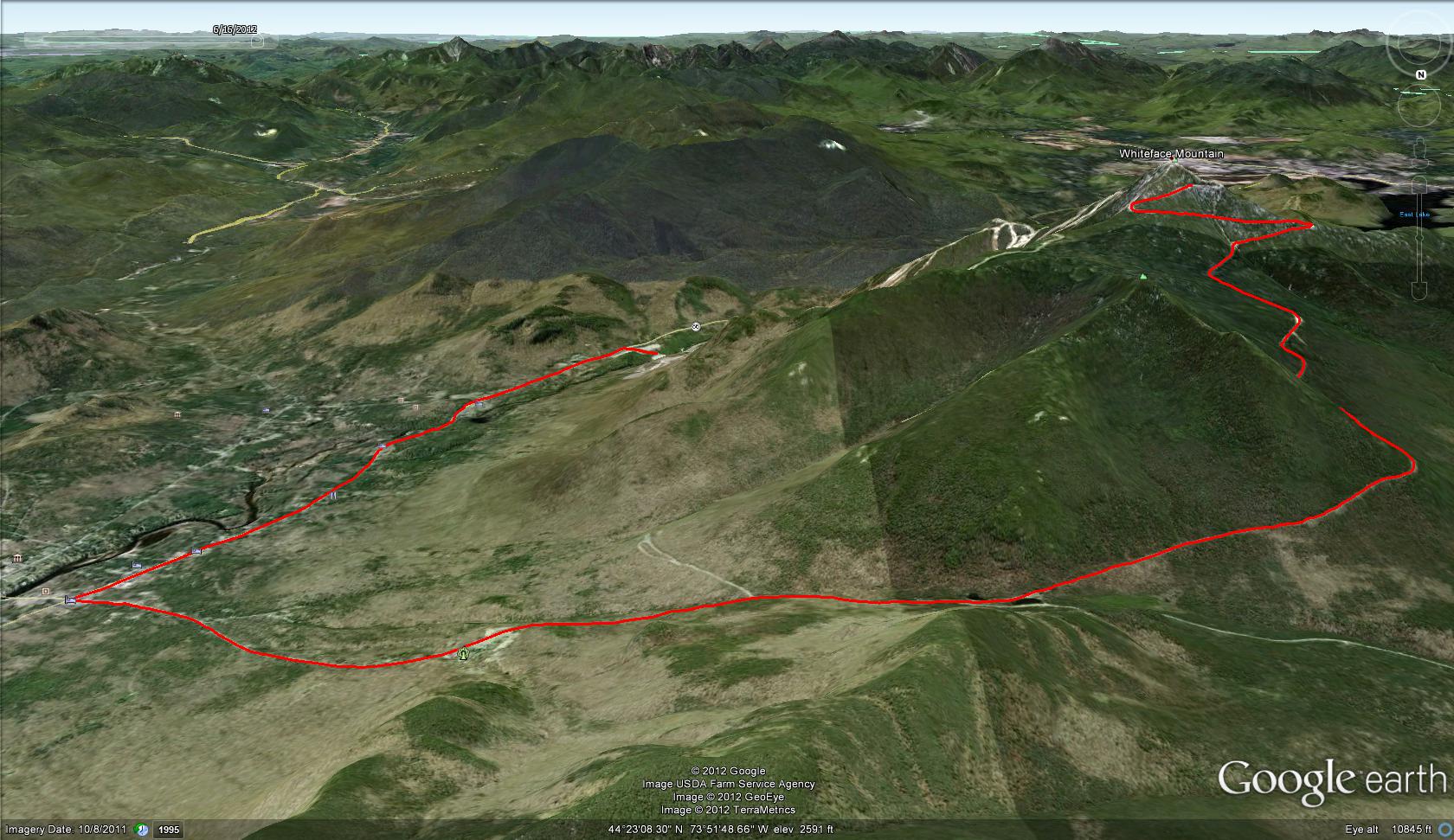
Whiteface Mountain, NY Whiteface Mountain is located just outside of Lake Placid. Whiteface is second only to Mt Washington in vertical gain. The view from the top is quite spectacular. Prior to 2012, the course started at the four-corners in Wilmington and climbed monotonically 3500ft in 8mi. Now the race starts at the Whiteface Mtn ski area and adds three miles, mostly downhill before the actual climb starts. The climb does not deviate much from 8% grade. This doesn't mean it is easier than the 12% climbs reviewed here, it means you just go faster. Most riders will not need radical gearing to conquer Whiteface, but a compact crank with up-sized cassette will still be needed for most. The climb kicks off with about 9% grade for first three miles. It flattens some around the toll booth area, then resumes 9% grade for the next three miles before tapering off again. Whiteface provides an exhilerating descent with the road resurfaced in 2015. The long straight-aways between turns draw you into adrenaline pumping speed. Use care when overtaking slower riders. The lower three miles of the descent are straighter. You'll develop fatigue from clenching the bar so tightly as your eyes tear up in the wind. For a long time, my highest speed record was on the lower portion of Whiteface. Do be careful though. I personally know two guys that have wrecked hard on descents. It is never a pretty sight. Bicycles are allowed to ride the toll road during operating hours after paying a toll ($8 in 2015). You may want to see about paying your toll first if timing yourself on a training climb, else you'll have to stop at the tolls. See Toll Road or Hill Climb and click activities for more info on toll road hours and the race respectively.
Mount Equinox, VT This course climbs Skyline Drive to the summit of Equinox Mountain. Bikes have not been allowed on this private auto road for many years. The Gear Up for Lyme race in 2004 was the first chance for hillclimbers to test their mettle on this beast. It is claimed to have a short section of 28% grade, but after racing this mountain, my hunch is I didn’t encounter anything steeper than 15 or 16%. The climb has one brief, fast descent the prevents it from being a truly monotonic climb. For the last few years, a $500 cash prime has been offered for the first ride to pass the one mile mark. $500 for a mile? How hard could that be? Oh, to collect the prize, you must also finish the race within a cutoff window. The view from the summit is spectacular. Mt Equinox is steep and one of the highest peaks around, so great views abound from several vantage points, especially from the open ridge line leading to the summit. The road is smoothly paved, tollbooth to summit. Unfortunately, like Mt Washington, cyclists are not allowed to ride their bikes back down. See GearUpForLyme for more info.
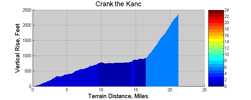
Crank the Kanc, NH The “Crank the Kanc” time-trial is one of the lesser known hillclimbs. It is not a pure hillclimb, however. This course starts out near Conway, NH and follows the Kancamagus Highway (Rt 112) to the top of Kancamagus Pass. The course climbs very gradually the first 10 miles before nearly leveling off for another 5 miles. Then the last 4 miles of the 21 mile course are fairly steep, averaging 7% grade with short steeper sections. There are a couple of spectacular vista points along the way. Be sure to enjoy them on the way back down. I have never done this timed event, but I have ridden the Kancamagus Highway on many occasions. The “Kanc,” as it is often called locally, is the backbone to many great cycling rides in the White Mountains of New Hampshire. As of 2010, most of the Kanc has been reconstructed. The Kanc west of the pass has been resurfaced and is now fantastic to bomb down. Lower portions east of the pass still need work. The reworked sections offer slightly widened roadway, making it a much safer and more enjoyable ride. For more information on Crank the Kanc, visit Crank the Kanc.
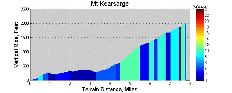
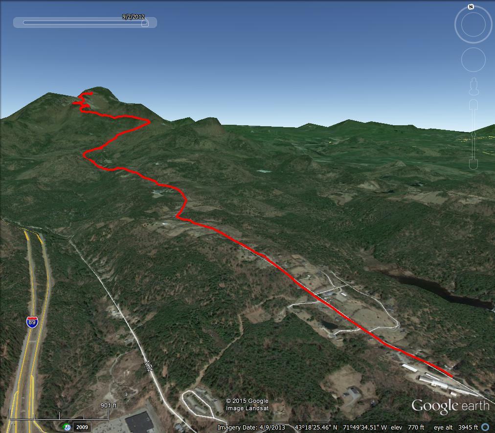
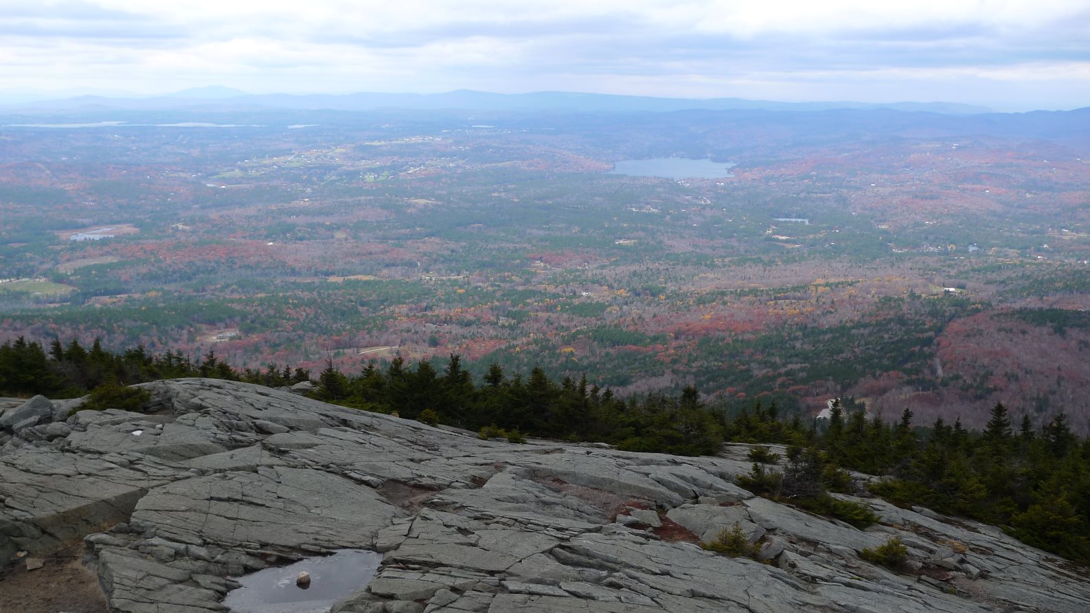
Mt Kearsarge, NH Mt Kearsarge was added to the BUMPS Challenge in 2013. The course starts near the village of Warner, gradually climbing up rolling terrain on Mountain Rd, before entering Rollins State Park where the real work begins. Once passing the entrance rotary, where a toll ($4 in 2013) is collected in summer months, the grade kicks up into double-digits. This is roughly the 4.4 mile mark in the profile below. The next mile is the steepest on the course, nearing that of Mt Washington's 12% grade. Once you get through this mile, there are occasional respites from double-digit climbing and even a brief downhill. A final push of steepness suddenly dumps you out onto a gravel parking area with superb view to the south. You might consider sending a pair of hiking shoes to the finish for the half-mile hike to the bald summit. The panoramic views in all directions are impressive for this far south of the White Mountains. Note you will want all of your gears for this hillclimb. There are flat and two significant downhill sections en route to the state park. Kearsarge shares this in common with the Okemo and Whiteface race climbs. Although the summit road was resurfaced a few years ago, it is getting ragged again. With a few sharp switchbacks and frost heaves popping up, great care must be taken on the descent. For race info, see the Mt Kearsarge Hillclimb website.
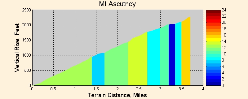
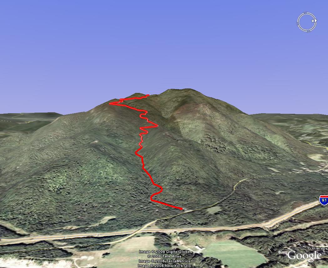
Mount Ascutney, VT Due to the increasing popularity of the Mt Washington hillclimb and park management noting a dramatic increase in riders training at Mt. Ascutney, the park decided to hold their own race in 2000. It was my first hillclimb race. 90 riders competed in the inaugural event, and now over 200 riders register for this race. As you can see from the comparison graph at the top of the page, the first 1.5 miles of Ascutney gain significantly more vertical than any other climb. There reportedly are short but sustained 19% grade sections. I find Ascutney a more grueling climb than Washington. It’s only half the vertical so you push harder in the race knowing the pain will be over in 30 minutes. Ascutney has some very tight switchbacks and a few frost heaves, so care must be taken on the descent. Since much of the surface has been repaved in 2005, the descent is much more enjoyable. It’s still a good idea to reduce tire pressure and stop for rim cooling however. Many riders have blown tires off their wheels descending this mountain, especially larger riders. You can ride Ascutney anytime for a small use fee. I have taken my mountain bike up Ascutney on a couple of occasions. There is some brutally rugged off-road riding around the summit of the mountain, which rises a couple hundred additional feet above the parking lot at the top. This is the best mountain in New England to test your Mt. Washington race gearing on. Ascutney is also a popular hang-glider launch mountain. For more info, check out Penguin Cycles.
No other climb presented here gains over 1000 feet in the first 1.5 miles, or in any 1.5 miles section, like Ascutney does. A very good warm up is required before racing this mountain. There may be a couple brief sections around switchbacks between 1.5 and 2.6 miles to let up just a tad, but the only significant break is around the 3.2-3.5 mile area. There is actually a brief downhill here. This poses a big problem to many riders though. It is too easy to back off, maybe even coast briefly in this section. Don’t do it! What happens is the final pitch gets exceedingly steep. You think there’s only a few tenths of a mile to go, so how hard could it be? But when you back off and recover, even if for a moment, it is very easy to go deeply anaerobic when the pitch turns steep again. Because this is near the end of the climb, you quickly hit deflection big time. This is the term often given to the condition when lactic acid rapidly builds, then the athlete must back way down to recover. It’s like hitting a barrier and deflecting off of it. This results in a net loss in time. It is better to maintain at least moderate power through the easy section, then resume steady hard pace on remaining steep section. You avoid going too anaerobic this way, which should net you a better finishing time.
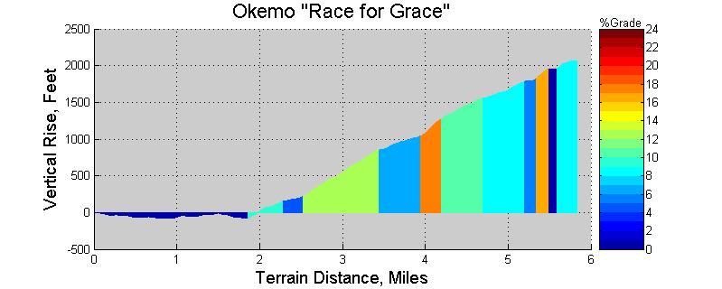
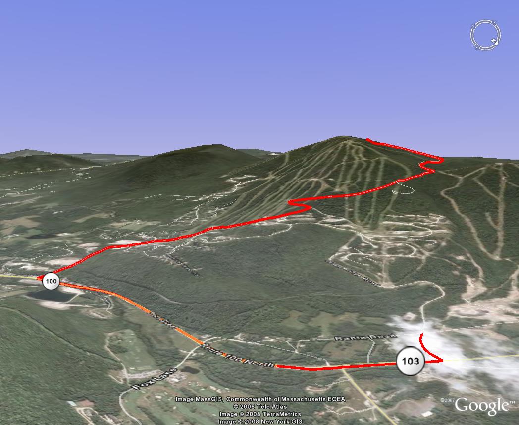
Okemo Mtn, VT Okemo Mountain in Ludlow, VT is another popular climb among cyclists. The paved summit road winds through the ski area en route to the summit. It is a state road, but not a park, so no entrance fee is required for those interested in training here. The Race for Grace is different from most other hillclimb events in that the race does not start at the base of the climb. It starts in Jackson Gore village and follows flat or slightly downhill Rt 103 for nearly two miles before picking up the steep summit road. This means racers need all the gears on their bike, as most will be traveling over 20mph to reach the base of the climb. The climb throws some really steep punches, but nothing like the first 2 miles of Ascutney. Okemo offers occasional breathers. The finish line is just shy of the end of pavement. There is minimal parking area at the summit, so most riders will be expected to ride their bikes back down. The pavement is decent for climbing, but great care must be taken on the descent. Like any New England road, old man winter eventually has its way with asphalt. There is no view from the finish area. The road does not reach the highest point. This requires approximately 0.25mi hike on jeep road, and view from top of chairlifts is nice, and view from fire tower is spectacular. Might be good to send a pair of sneakers up if you want to walk over to it while waiting for the last racer to finish. There are a couple of other nice vistas just down from the finish. Take time to enjoy them on the descent. This is an excellent venue for a hillclimb, as the facilities at Jackson Gore are first rate. A meal is served and awards presented promptly after the race. Check out Okemo Bike Climb for more info.
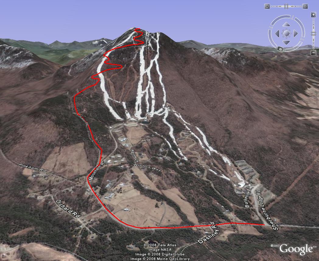
Burke Mountain, VT Burke Mountain is one of the premier climbs in northern Vermont. This climb is tough, I suspect many find it more difficult than Mt Ascutney. The average grade is about the same, but there are sustained sections that are much steeper than any comparable sustained section on Mt Ascutney. For this reason, it is hard to find a rhythm on this climb. Around the 1.7 mile mark, there is a section that approaches 20% grade for at least a few tenths of a mile. I find it difficult to keep front wheel on the ground. This grade is comparable only to the east side of Lincoln Gap in the Green Mountains. The race starts on Mountain Road at the ski area entrance. The grade is gentle here, and you'll think you're racing in a road race pack. Once the fork to the Toll Road is taken, the grade immediately kicks up to 14% and stays there until the 20% grade section. The rest of the climb hovers in the 12-15% range. Ski runs are crossed several times on the way up, offering fantastic views and giving you a psychological boost in showing how dramatically you have gained vertical despite crawling at just a few miles per hour. At the summit, a two minute hike from parking area, there is a fire tower that can be climbed for a 360 degree panoramic view. On a clear day, you can see mountains in several states. One of the best things about this climb is the road condition. It has been recently repaved, so the surface is buttery smooth. However, great care must be taken on the descent. Due to extreme steepness and frequent sharp switchbacks, heavy continuous breaking is required. Even my MTB disk brakes faded on me one time coming down. This has never happened before riding off-road. Most riders would do well to reduce tire pressure about 10-15% before beginning the descent and stop half way down to let rims cool. Hillclimb races have had a pretty safe track record over the last 8 years I’ve been into it. Let’s keep it that way. For more info, see Burke.
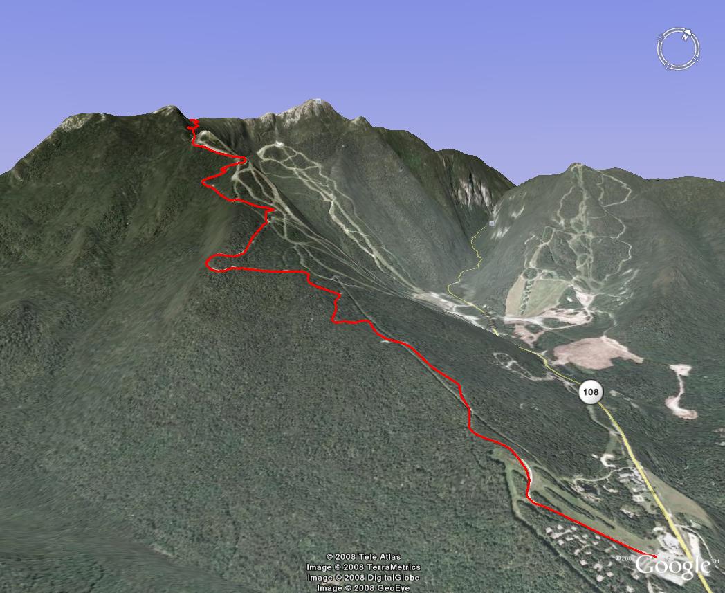
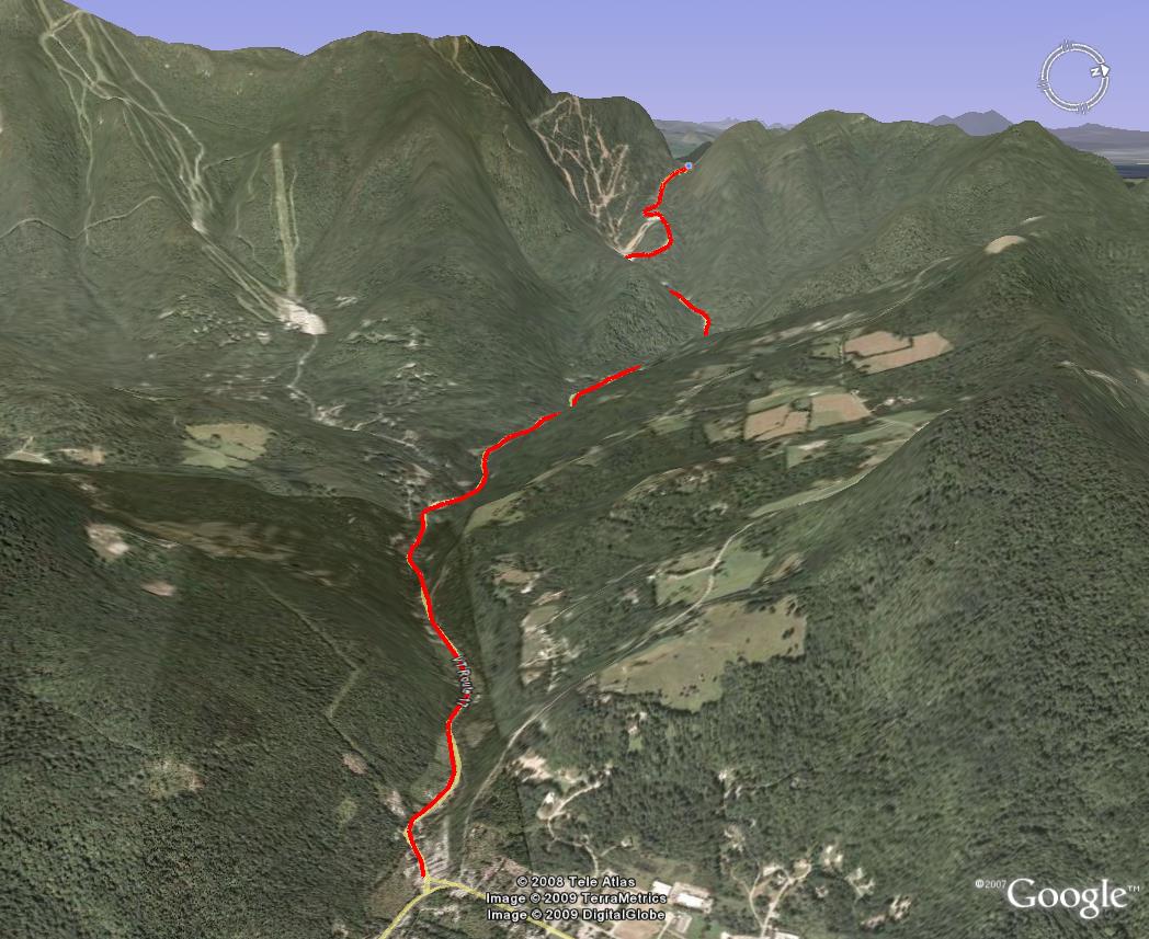
Mt Mansfield, VT Mt Mansfield came back into the hillclimb racing scene in August, 2008. The race is dubbed Race to the Top of Vermont. Generally, bicycles have been forbidden on this private toll road. It is unique from all of the other hillclimbs in the following way: mountain bikes with minimum 2" wide tires are required. Sure, some might be able to reach the summit on road or cyclocross bikes, but the organizers wanted to keep the playing field equal and the race safe. Most riders are expected to ride their bikes back down after the race. The race starts on a paved section that looks and feels like a formidable wall at 13% grade. However, only the first 0.3 miles is paved. The remaining 4 miles are gravel. The pitch of the climb undulates something fierce. It is hard to find a groove on this climb. You'll constantly be churning through gears. At least with a mountain bike, you'll have gears that go plenty low. As vertical is gained, the climb becomes a little bit more exposed to the sun in spots, drying the gravel out so that car traffic can make washboard bumps. This is not much of a problem climbing with fat tires, but it does make for some tense moments on the descent after the race. There are a series of switchbacks more than half way up that are really steep. At least it stayed consistently steep here, so it was easier to meter out the power. Then again just before the finish, there were a few more switchbacks, a couple very steep. You don't have to be a mountain biker to do well in this race, but you will need a bike that can accommodate 2" wide tires. The field sizes doubled from 2008 to 2009, and in 2010, combined entrants are limited to 900. The runners are staged 10 minutes behind the riders, yet many riders got passed by runners! The fastest runners can beat the fastest riders on this mountain. It seems that runners achieve parity with riders on a 12% dirt grade with heavy mountain bikes. On paved surfaces with light road bikes, riders are quite a bit faster than runners on a 12% grade. On pavement, I estimate parity is achieved at around 16-17% grade. The view from the summit is fantastic. Short hikes along the ridgeline open up more viewing opportunities. You can catch a birdseye view of Smugglers Notch. It doesn't look as deep from 4000ft as it does when you ride your bike through it. For more info, see Catamount and look for RTTOVT.
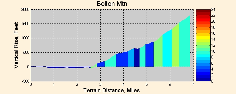
Bolton TT, VT The Bolton TT is put on each year by the Green Mountain Bicycling Club, usually mid-week in mid-summer. I’ve not done the TT, but I have ridden the course. The TT begins over two miles from Bolton Valley Access Road on Rt 2 and is actually slightly downhill. The climb ends at the base of the ski area, not the mountain summit. The first 2.5 miles of the access road are undulating with some short 10-12% grade sections and one slight downhill. Then you hit the double switchback and it stays very steep for the remainder of the climb. The descent is one of the best out there. Only one or two bumps near the top, then terminal velocity much of the way down. Be sure to watch your speed (and on-coming cars) through the double switchback however! See GMBC for more info.
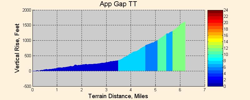
Appalachian Gap TT (Allen Clark Memorial Hillclimb), VT (location) The “App Gap TT” begins at the Rt 17/Rt 100 junction in Waitsfield. The TT route follows Rt 17 to the summit of App Gap. It climbs gradually at first, becoming increasingly steep. The last 2km averages over 10% grade, while the last 500 meters approaching the summit averages 13%. This side of Appalachian Gap has been used as a mass start prologue course in the Green Mountain Stage Race (GMSR) in years past. I have done the GMSR race before, but never the Allen Clark TT. The view from the summit to the west into New York is fabulous. The paved surface is generally in pretty good shape, but riders descending after the race must take extreme care. There are a couple sets of switchbacks that are much sharper than you think. You cannot take these at 50mph, or even 40mph. Riders have been seriously hurt going into or over the guardrail around these turns. For more info, see Allen Clark.
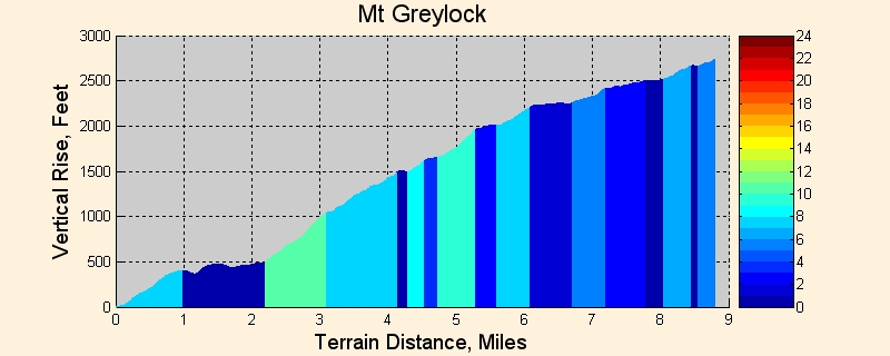
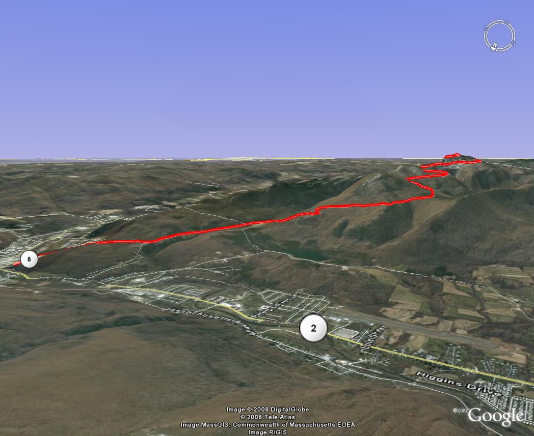
Mount Greylock, MA Located in the Berkshires of Massachusetts, Mt. Greylock offers a very respectable climb with spectacular views. The course begins just off Rt 8 in N. Adams on Furnace St, then hangs a quick left onto Reservoir Rd, which is perhaps the steepest part of the whole climb and you haven’t even left town yet. You can park right there at Heritage State Park. It starts out with several sustained, very steep sections, then moderates as you approach the summit. One significant downhill early in the climb will get your speed up to about 40mph, so you’ll need all your gears. The flatter portions at top will also let stronger riders cruise around 20mph. The Spoke bicycle shop has organized this individual time-trial format race for many years, mostly as a local word-of-mouth type of event timed with stop watches. In 2004, registration was available online as a licensed USCF TT event. The road, along with the race, was shut down for a couple of years to make badly needed repairs. In May 2009, the completely reconstructed auto road has been re-opened. Look for buttery smooth surfaces to climb and descend on, but use care on the hiker crossings with rumble strip surface. The time-trial format race returns in 2010 under new leadership by the Northhampton Cycling Club, and it will be part of the BUMPS Challenge. For more info, visit the NCC website.
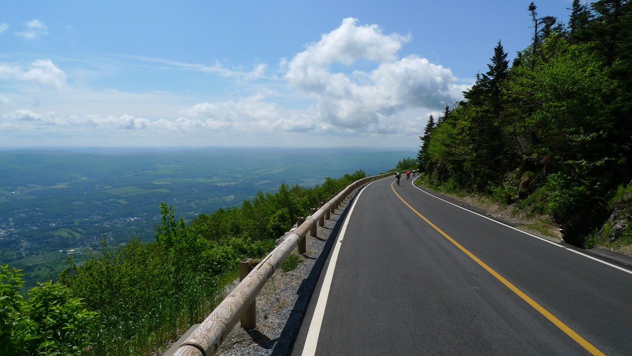
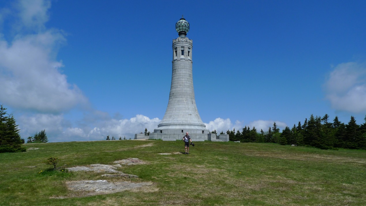
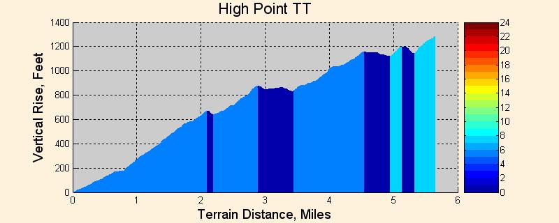
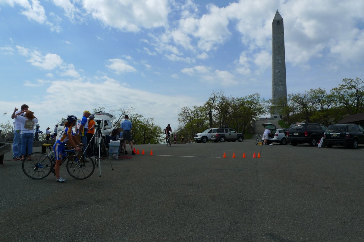
High Point Hill Climb TT, NJ (location) This time-trail format hillclimb has been running for 20+ years now, as a low key USAC sanctioned event. The course starts at a Dairy Queen just off I-84 in Montague, NJ. It climbs on route 23 for the first several miles to the entrance of High Point State Park. The grade along Rt 23 is never steep, and in fact, there are some rolling sections where you will surely need a big ring. Many competitors here sport aero wheels and helmets. Once in the state park, a narrow one-lane road is taken for most of the remainder of the course. This section rolls along the ridgeline and has some very steep grades in it, easily over 12%. These come right after brief, screaming descents too, so you'll need to drop through ALL of your gears in just seconds. Make sure if you are running a compact crank your chain doesn't have tendency to drop when going to the little ring. The finish line is where the pavement plateaus just before dipping to large parking area. It is not at the monument itself. The monument sits at the highest point in the state of New Jersey. We are lucky in the northeast to be able to reach so many state high points by bicycle. Skylands Cycling has been running the event the last few years. Peruse their calendar to see when this event occurs, usually in April or May.
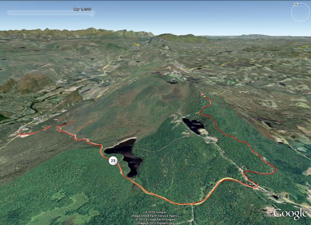
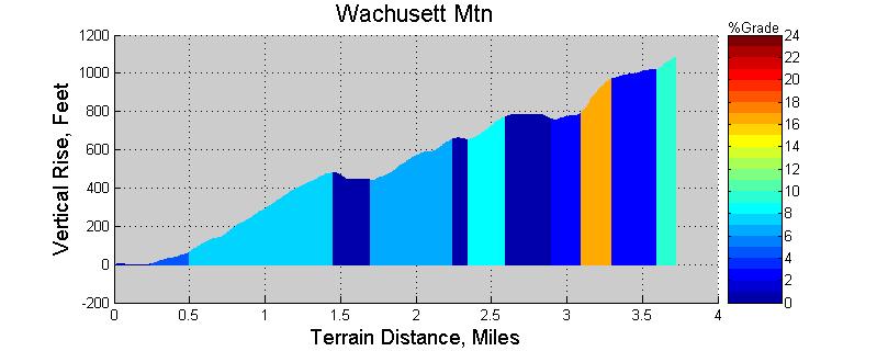
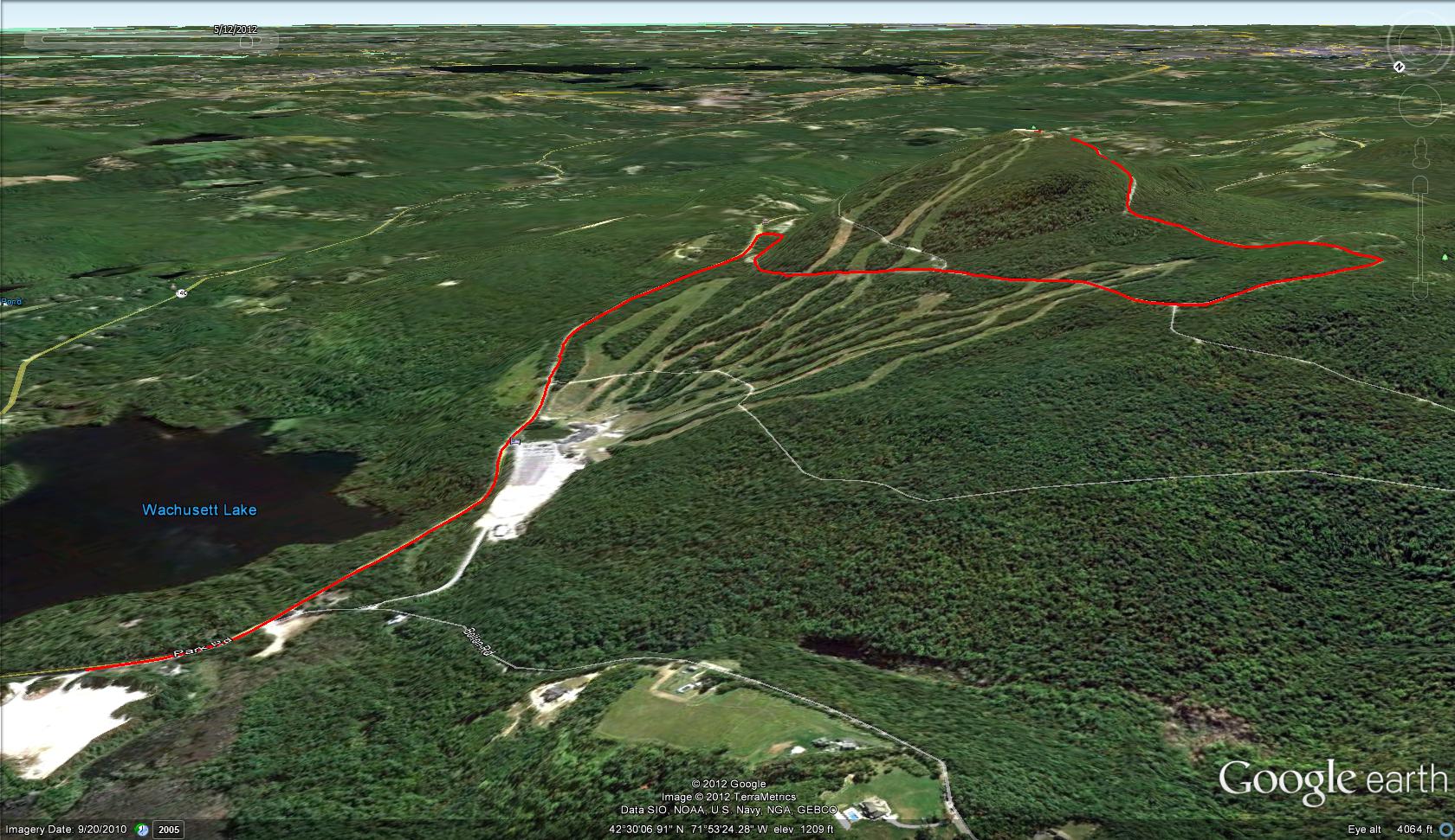
Wachusett Mountain, MA After a nine year hiatus, Wachusett hillclimb races are back on the calendar. The summit road as been fully reconstructed and provides buttery smooth asphalt for the climb and descent. Within the state park, a one-way road wraps around the mountain with a small spur to the summit. The hillclimb race starts on Mile Hill Rd at a gravel ski area overflow parking lot between Rt 140 and Bolton Rd and follows the one-way route to the summit. Wachusett Mountain is the one of the easier hillclimb races reviewed here. There are some sustained steep sections, but a couple flat or slightly downhill bits allow recovery if you overcooked a steep section. The first mile is possibly the hardest part, averaging around 8-9% grade. Punchy steep bits are encountered within the state park, and the last little bit to the parking lot up top approaches 15% grade. On clear days you can see Boston from the summit. Expect great food and awards afterwards at the ski area with the green slopes as a scenic backstop. See Wachusett Mtn Hillclimb for more info.
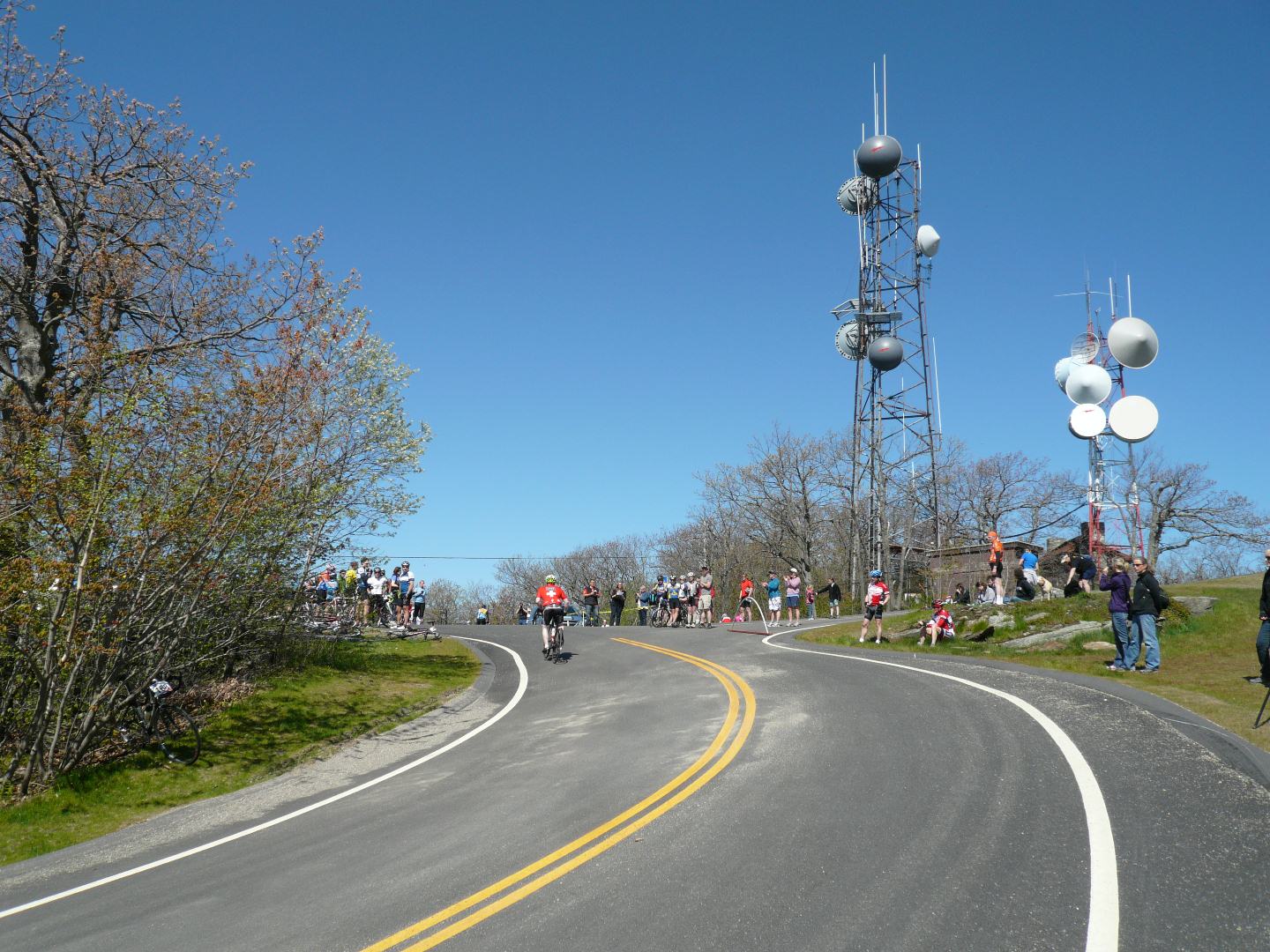
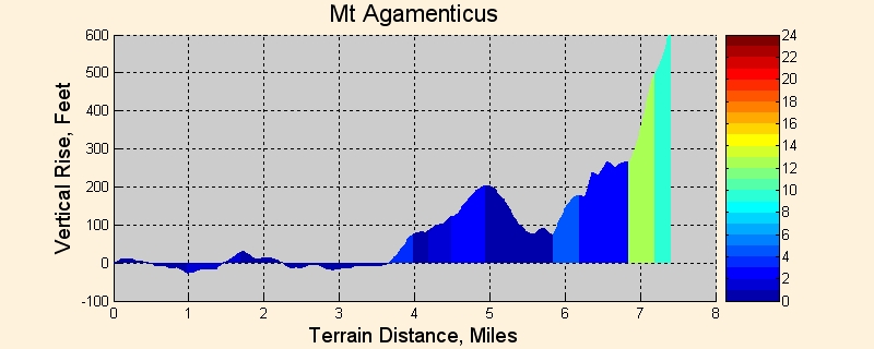
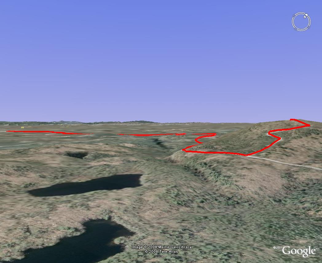
Agamenticus TT, ME The Mt Agamenticus (Mt. Agi) is a mixed-bag TT with lots of character. Starts just outside of S. Berwick town center near the intersection of Agamenticus and Willow roads. The first few miles of the course are fairly flat, where Agamenticus Rd is taken to Emery’s Bridge Rd. However, once you turn right on Belle Marsh Rd, climbing begins, but not steeply. A left is taken on Mountain Rd, which climbs a little further before a brief descent occurs. Beware, the descent starts paved and good speed is built up, but before you reach the bottom, the road turns to gravel. The gravel can be loose washboard bumps with large stones, and it is not straight. One time when I came down this, the washboard nearly rhythmically bounced me right off the road at 30+ mph. Then the steep climbing begins, still on dirt. Depending on time of year, recent rain or lack thereof, and maintenance, you may have to hunt for a good line to not lose traction with skinny 23mm tires. About 200ft of the 500+ foot steep climb is gained on gravel. Upon reaching pavement, a left is taken on Mt Agamenticus Rd to the summit. Some portions of this hit 14% grade. There are a few steep, sharp switchbacks too. This is a great TT to test all around skills. There’s no one clear advantage, say as in a purely flat TT or pure hillclimb. Those with off-road experience will definitely feel more at easy on the potentially loose as marbles gravel. See Maine TT Series for more info.
|
|
Links to Hillclimb Race Results Bicycle hillclimb race results appear to be scattered all over the place. Bikereg.com, Coolrunning.com, and various sponsoring websites are some of the places these results can be found. Here I have compiled links to recent northeast hillclimb results.
Agamenticus 2010-cancelled, 2009, 2008, 2007, 2006, 2005, 2004
App Gap (Allen Clark Memorial Hillclimb TT)
Ascutney 2012, 2011, 2010, 2009, 2008, 2007, 2006, 2005, 2004, 2003, 2002, 2001, 2000
Bash Bish Hill TT
Bolton TT
Burke 2012, 2011, 2010, 2009, 2008, 2007
Equinox 2011, 2010, 2009, 2008, 2007, 2006, 2005, 2004
Greylock 2012, 2011, 2010, 07-09-paving, 2006, 2005, 2004
High Point Hill Climb TT 2013, 2012, 2011, 2010, 2009, 2008, 2007, Archives
Kancamagus (Crank the Kanc TT)
Mansfield (Race to the Top of Vermont)
Okemo
Wachusett TT 2013, 2012 results disappeared Old Wachusett TT Course Results: May_2003, Jun_2003, Jul_2003, Aug_2003, May_2002, Jun_2002, Jul_2002, Aug_2002
Washington
Whiteface 2013, 2012, 2011-2007 have disappeared, 2006, 2005, 2004, 2003, 2002 |