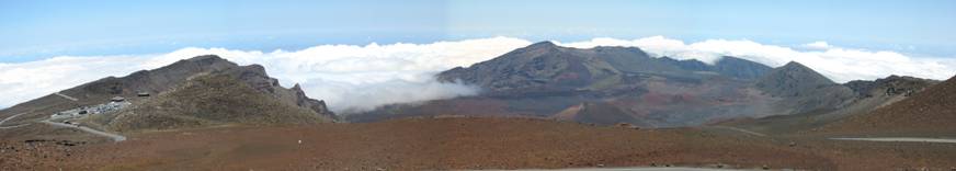
Haleakala National Park summit view, Maui, Hawaii
Here I have compiled data and descriptions of some great climbs I’ve done from elsewhere in the country. Most of these are out west or from Hawaii. New Englanders might have one of the toughest hillclimbs in the world with Mt Washington, but there are many climbs that are either much bigger vertical gain, go to much higher elevation, or both. About half of the climbs presented here are 100% paved, and one is 100% singletrack. The others are mixed paved/gravel or entirely gravel. If you like to climb and have opportunities to travel, maybe there’s something here you’ll like to try sometime.
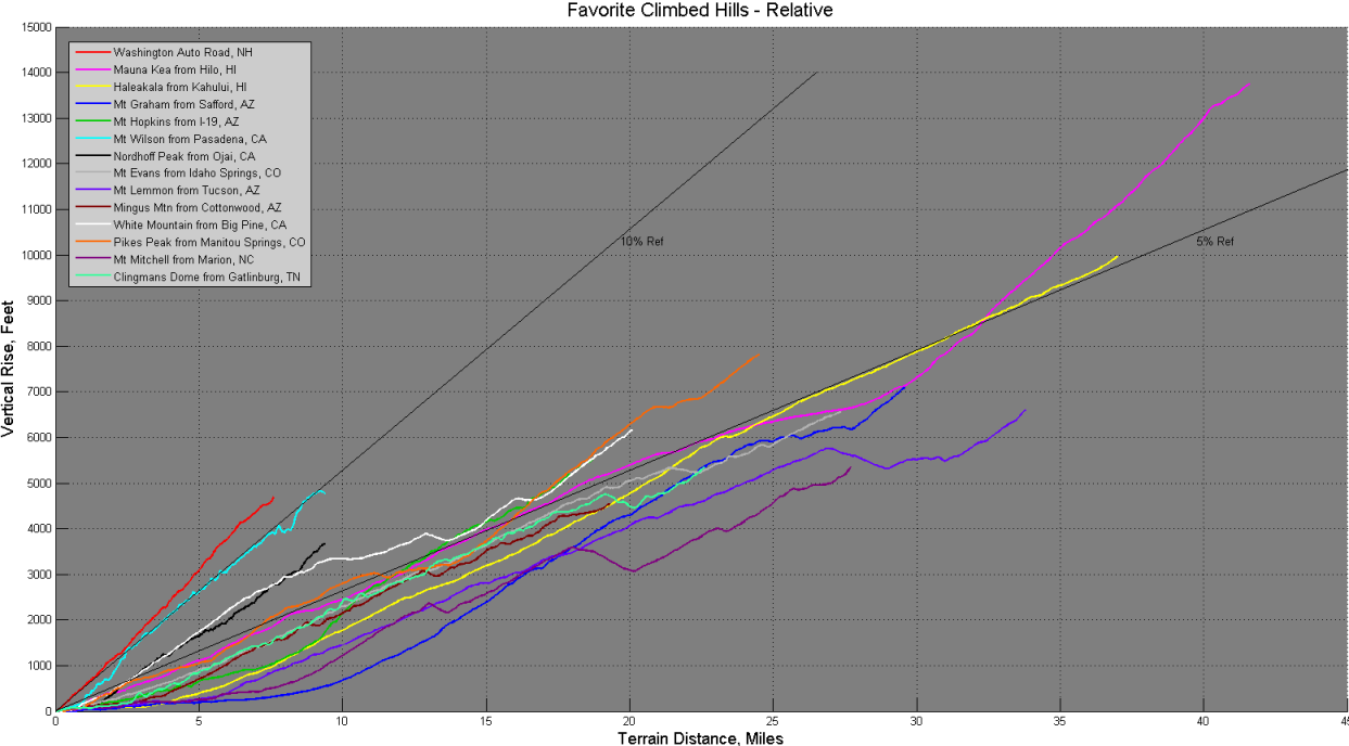
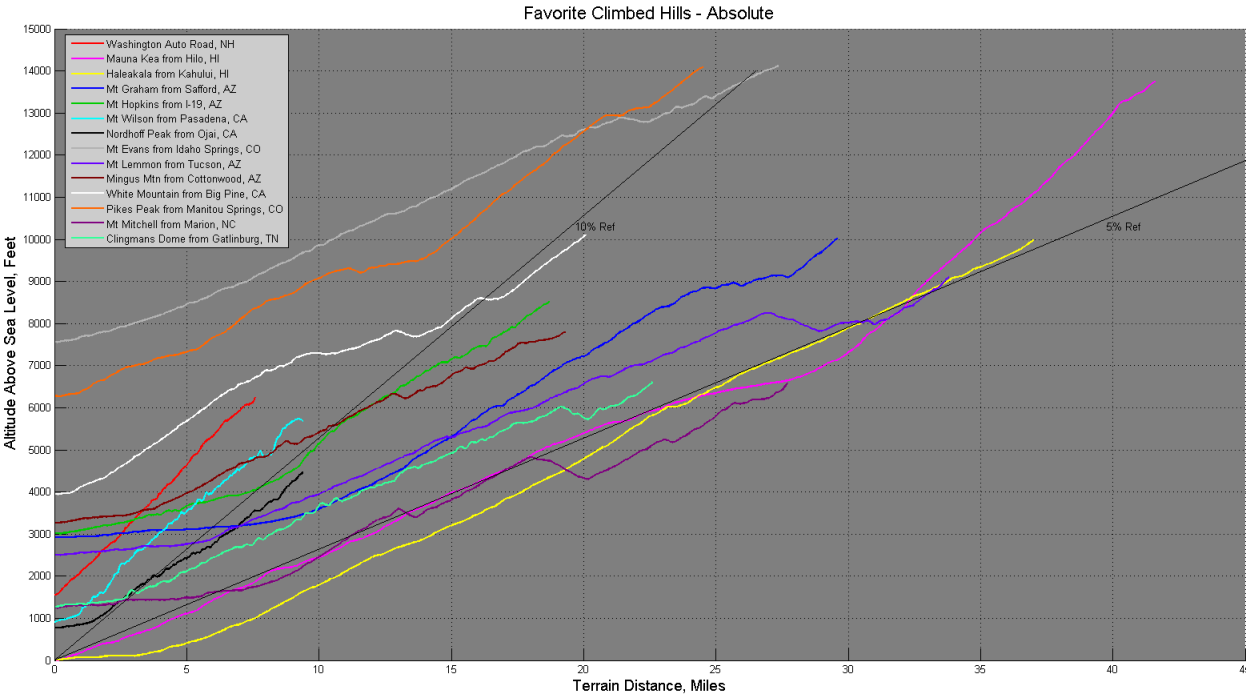
The climbs are depicted two different ways: in terms of elevation gain to allow comparison of relative steepness, and in terms of absolute altitude to show how high some of the climbs reach. The two Hawaiian climbs start at sea level, rising to 10,000 and 13,800 feet. Mt Evans on the other hand, while finishing above 14,000 feet, starts at 7,555 feet. Because Mauna Kea on the Big Island encompasses both huge elevation gain and high altitude climbing, it easily dwarfs the other climbs presented here in difficulty.
Quantitative Stats on the Climbs – Ranked by Fiets Difficulty Index
|
Climb |
Surface |
Vertical |
Terrain (mi) |
Avg Grade (%) |
Max Grade (%) |
Max |
Fiets Difficulty Index* |
|
Mauna Kea |
88% paved/12% loose cinder gravel |
13,790 |
41.6 |
6.3 |
18 |
13,796 |
29.6 |
|
Pikes Peak |
90% paved |
7830 |
24.5 |
6.1 |
|
14,110 |
17.7 |
|
Haleakala |
100% paved |
10,010 |
37.0 |
5.1 |
|
10,023 |
17.7 |
|
Washington Auto Road |
80% paved/20% packed gravel |
4727 |
7.6 |
11.9 |
22 |
6,253 |
17.7 |
|
Mt Wilson Toll Road |
100% rough gravel |
4797 |
9.4 |
9.7 |
|
5,710 |
14.9 |
|
White Mountain Peak |
100% paved |
6174 |
20.1 |
5.8 |
|
10,117 |
13 |
|
Mt Evans |
100% paved |
6580 |
27.3 |
4.6 |
|
14,135 |
12.4 |
|
Mt Graham Highway |
Paved/last 2mi gravel to Heliograph Pk |
7108 |
29.6 |
4.6 |
|
10,028 |
11.9 |
|
Mt Hopkins Access Road |
90% gravel |
5544 |
18.7 |
5.6 |
|
8,585 |
11.1 |
|
Mt Lemmon |
100% paved |
6651 |
33.8 |
3.7 |
|
9149 |
9.3 |
|
Nordhoff Peak, Gridley Trail |
Singletrack Trail |
3711 |
9.4 |
7.5 |
|
4,485 |
8.8 |
|
Clingmans Dome |
100% paved |
5374 |
22.6 |
4.5 |
|
6,643 |
8.4 |
|
Mingus |
First 85% paved |
4555 |
19.3 |
4.5 |
|
7816 |
7.6 |
|
Mt Mitchell |
100% paved |
5433 |
27.7 |
3.7 |
|
6,684 |
7.2 |
* Difficulty index from Dutch cycling magazine Fiets. It is computed by H^2/(D*10) + T(>1000m)/1000, where H is height in meters, D is terrain distance in meters, and T is summit elevation in meters (if above 1000 meters). This metric puts emphasis on steepness of climbs, and adds additional difficulty for climbs that finish above 1000 meters (about 3,300 ft) above sea level. For more info, see fiets or here. My numbers may differ from other published numbers due to differences in exact starting location. The Fiets index also does not take heat, wind, mud, gearing, rider fatigue, etc into account.
Brief Climb Descriptions (click on photos for better resolution image)
|
|
Mauna Kea, Hawaii, HI This mostly paved climb is perhaps the largest rideable climb in the world. The first 34 miles are paved, then 5 miles often loose cinder gravel, and then 3 final miles of pavement. The first 28 miles up Saddle road from Hilo gains only 6600 feet at modest grade, tapering off to almost flat in the saddle between Mauna Loa and Mauna Kea. Turning off onto Mauna Kea Access Road is a real shocker, as you are now faced with sustained 17% grades at high altitudes. The Fiets index for this climb is off the charts at nearly 30. It’s a combination of net gain and high altitude driving the high rating. Like Haleakala, views are too good to describe with words. Many of the world’s most powerful telescopes are at this summit.
|
|
|
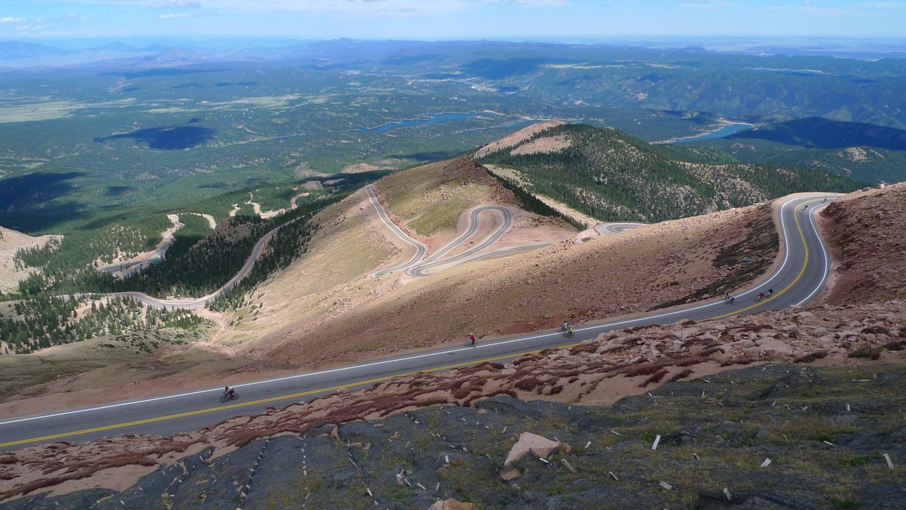
Pikes Peak, Manitou Springs, CO In 2010, cyclists gained access to Pikes Peak during the Assault on Pikes Peak timed fun ride. The ride started from a very low elevation in Manitou Springs, went up a closed lane of US-24, then on to the summit via the toll road. Hopefully this event is offered in the future, as bicycles are not permitted on the toll road otherwise. Of all the timed hillclimb events, this is most likely the most difficult. It presents the rider with nearly 8000ft of vertical gain, sparse air at 14,000ft, and the potential for very high winds as experienced in 2010. Like Mt Evans nearby, the scenery is fantastic. Unlike Mt Evans, Pikes Peak is much, much steeper, including six miles of continuous 10% grade as you rise above timberline. The toll road used to be all gravel at one time, but the town is slowly paving the upper sections. In 2010, approx. 2.5 miles remained unpaved but were well groomed and suitable for racing road bike tires. The best parts about the climb are freshly fried donuts at the summit house and the descent on miles and miles of new asphalt. This climb achieves the same Fiets index as Mt Washington and Haleakala due to it meteoric rise into thin air.
|
|
|
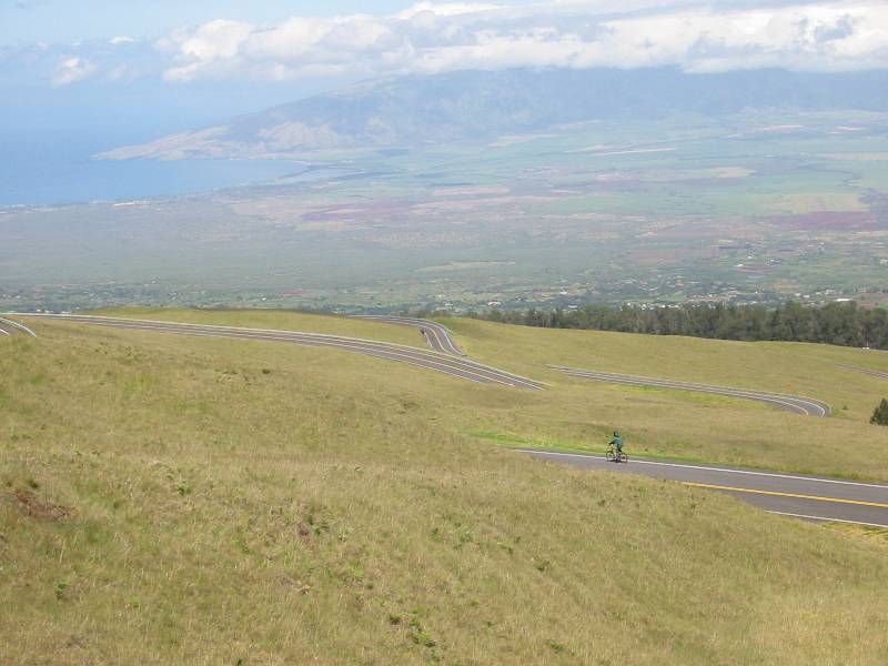
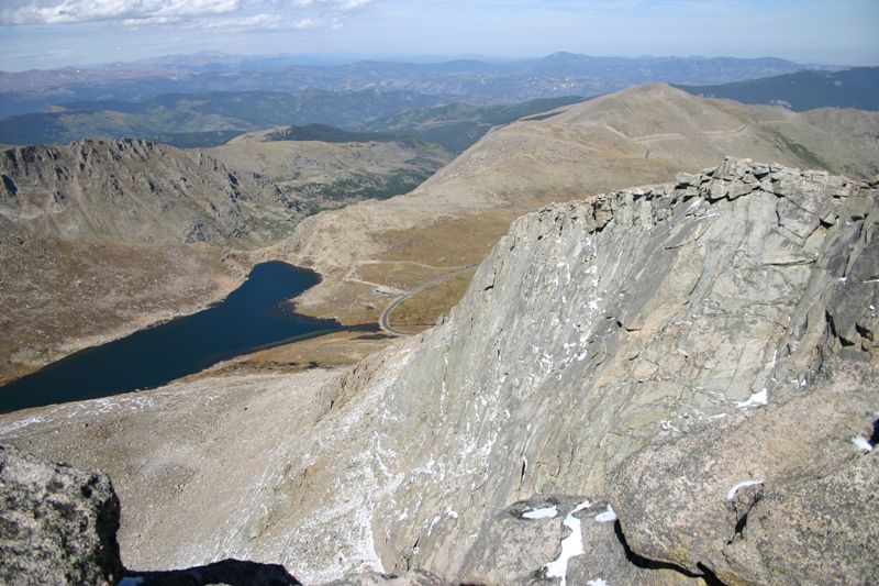
Haleakala, Maui, HI If this climb weren’t in the middle of the Pacific Ocean 2500 miles from nearest land, it could perhaps be the most popular bicycle climb in the world. The fully paved climb to the summit gains just over 10,000 feet from sea level in less than 38 miles. At the summit, you are only 6 miles, as the crow flies, from the ocean. No where else in the world can you be this close to the sea at this elevation. Views are stunning everywhere you look, especially the Martian landscape at the summit. I calculate the average grade to be 5.1%, and the entire climb feels like it deviates very little from this. There’s barely a down slope the whole way up. Only near the summit does the grade pick up some, but maybe only a few percent. I began this climb in Kahului, taking Rts 37, 38, and 377 to the summit.
|
|
|
Mt Washington, New Hampshire The Mt Washington Auto Road is reviewed elsewhere on this site (>1000 foot climbs). It is included here as a reference standard. I compare all other climbs to Washington, such as Ascutney is same grade, half vertical, or Haleakala is half the grade, but twice the vertical. In a race scenario, Mt Washington is indeed a very hard mountain to climb. I have practice climbed or raced up Mt Washington many times.
|
|
|
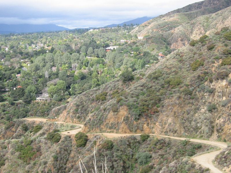
Mt Wilson, Pasadena, CA The Mt Wilson Toll Road is a closed gravel road. It is open to non-motorized recreational use. The surface is pretty decent, but loose sections, occasional rock slides, and embedded sharp rocks pretty much necessitate a mountain bike or at least a cyclocross bike with some decent tires on it. There is paved access to this summit from the other side for the observatories. I have climbed the Mt Wilson Toll Road twice on a hardtail mountain bike. I have met other hillclimber/competitive types on the climb, who descend the toll road the way they came up. That’s too bad. Many miles of incredible singletrack can be accessed from the summit areas of this range. I have taken Gabrielino Trail down on one occasion, and a mix of Mt Lowe Rail Path, Echo Mtn, and Sam Merrill trails on another. Stunning views of both the Angeles National Forest and the Los Angeles basin. To get 4900 feet vertical, you must start at the Eaton Canyon park entrance and sneak through.
|
|
|
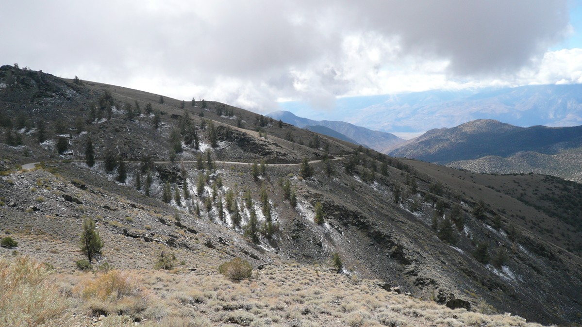
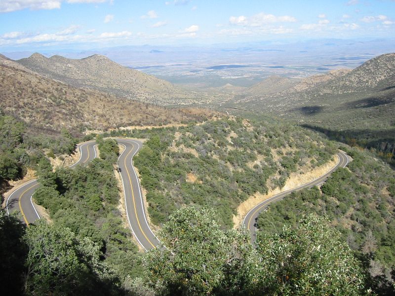
White Mountain, Big Pine, CA This climb is part of day two of the Everest Challenge stage race. It is fairly steep most of the way, but at several points along the climb the grade lets up or even drops for a bit. The road passes through many scenic areas, including a narrow pass through a gorge. It starts in desert waste land and passes through unique forested areas higher up. From vantage points near 10,000ft, you can look across the valley to glaciers in the Sierra Nevada’s. Just after cresting above 10,000ft, the road continues as abrasive gravel. On a mountain bike, one can reach the 14,000ft summit, but this option is not profiled here. Someday I hope to ride from Big Pine via Jeep road to summit, 100% on dirt, with >10,000ft net gain. The descent is marvelous, good pavement with very little braking required.
|
|
|
Mt Evans, Idaho Springs, CO This fully paved climb is often compared to Mt Washington in difficulty. The Fiets index from the table above suggests it is much easier than Mt Washington, despite gaining 40% more vertical in much thinner air. Presumably, this is due to huge average grade differences between the two climbs. Mt Washington is over 2.5 times steeper. However, I must say Mt Evans is pretty difficult for low-landers. The thin air above 10,000 feet has huge adverse impact on climbers not acclimated to the altitude. Comparisons aside, the scenery is spectacular here. One gets a strong “top of the world” sensation from the summit high point, which requires a short hike from the parking area. An annual hillclimb race is held here each year, the Bob Cook Memorial Hillclimb. Fastest times are under two hours.
|
|
|
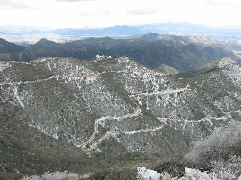
Mt Graham, Safford, AZ For maximum vertical gain, begin this climb from the town of Safford. A few miles of gradual climbing bring you to the Mt Graham Hwy , where the grade gradually ramps up. The surface is wonderful pavement (frost heaves are unlikely, at least on the lower elevations). To get above 10,000 feet, a rocky dirt access road is climbed another couple miles to Heliograph Peak. General public access is not allowed to the actual Mt Graham summit. The endangered Mt Graham squirrel has rights to anything above 10,000 feet, except for a few monster observatories. I climbed this at the end of October. It was 70’s in town, 30’s up top. There are many great views of the desert below, to the south where the paved road starts to level off, and to the north and east from Heliograph Peak. Races are held here each year, starting on the Mt Graham Hwy and finishing where the pavement levels off.
|
|
|
Mt Hopkins, Amado, AZ This climb begins from just off Interstate 19 and heads towards the Santa Rita Mountains. The summit of Mt Hopkins contains many observatories at 8,585 feet elevation. The road gains vertical very gently at first, on pavement. Once past the visitor center, there’s a couple more paved sections, but the bulk of the vertical is gained on well groomed gravel. I climbed this mountain once on a mountain bike. Other than the research buildings up top, there is nothing else out here. Most of the Santa Rita Mountains are protected by the Mount Wrightson Wilderness, a peak adjacent to Mt Hopkins. The air is very clear here, and the views are superb. You can see the Santa Catalina’s north of Tucson, flat desert floor in between.
|
|
|
Mt Lemmon, Tucson, AZ Starting on Tucson’s northeast side, this climb begins gently on the newly reconstructed Mt Lemmon highway. The grade is never steep, but the first 25 miles or so is pretty much all up hill. Many cyclists train on this climb, especially in colder months when mountains in most other parts of the country are socked in with snow. Mt Lemmon sees snow too, but generally only above 7000ft. The climb initially peaks out at 8200ft before descending 500ft into village of Summerhaven. Just before reaching the village, take a right on Ski Valley access road. This climbs a little more steeply. Go past ski area, under gate, and climb hundreds more feet to reach summit of mountain. This last two miles past the gate has deteriorating asphalt, so use care on the descent. Stunning views abound much of the way. Enjoy them while climbing, as you will be bombing down at 40+ mph for 25 miles on the descent. This climb nearly matches Mt Evans in CO on the relative scale, but Mt Evans starts almost a vertical mile higher in altitude! For the off-road set, you can mountain bike up the Jeep road on Mt Lemmon’s north side from Oracle. Steeper, and lots of giant rollers along the way.
|
|
|
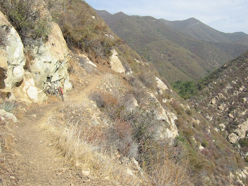
Nordhoff Peak, Ojai, CA This singletrack climb rises from the outskirts of Ojai on the Gridley Trail. Starts out very steep, maybe on the order of 20% grade, but then levels off into a sweet climbing grade. The trail clings steep canyon walls, and at times offers significant exposure (places you can’t afford to fall). It meanders all over the place, and every now and then you get a glimpse of where you where climbing 15 or 30 minutes ago way below. A short piece of fire road is taken to reach the lookout tower at the peak. From the peak, the Pratt Trail is taken back down to town. Again, stunning views the whole way. Numerous switchbacks force you to lay heavy into braking. Most of the trail surface is very smooth, sometimes a little loose, and non-technical. The last mile or two at the bottom can be a bit hard to follow and considerably more difficult with large rocks and rock structures. Have done this loop twice and is one of my favorite trail rides in California.
|
|
|
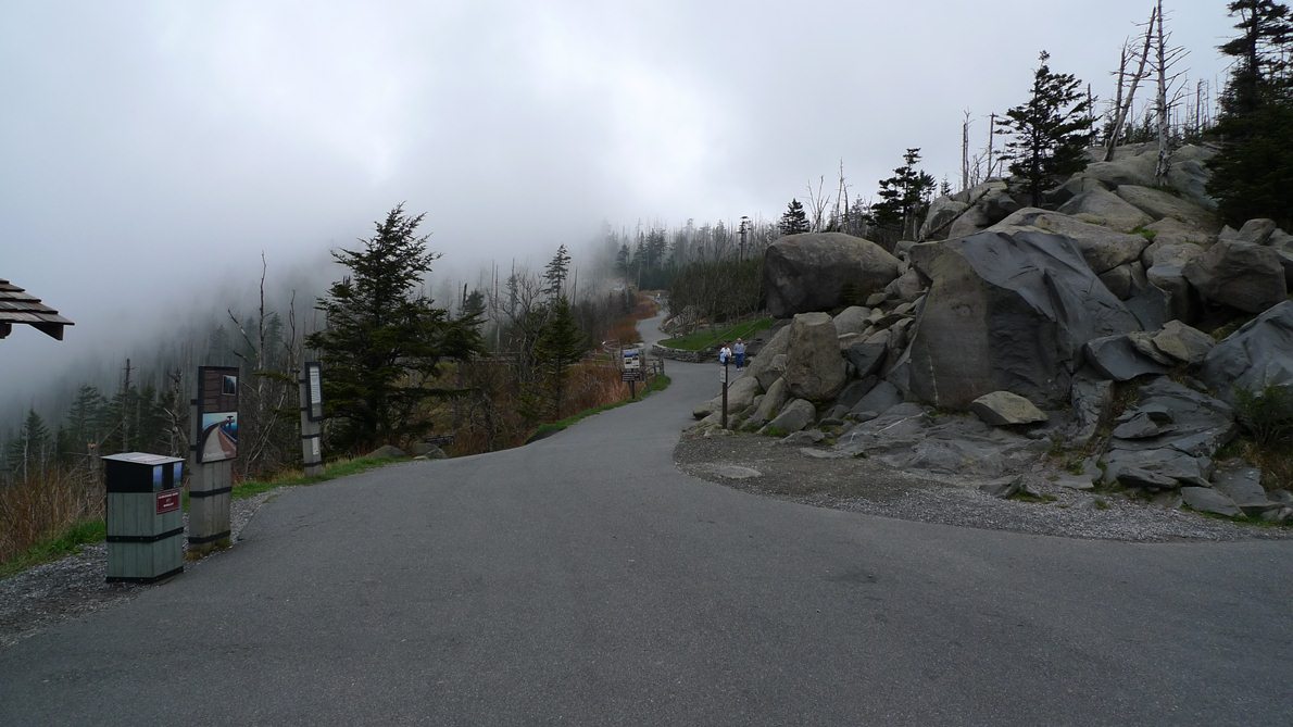
Clingman's Dome, Gatlinburg, TN Clingman's Dome straddles the border with Tennessee and North Carolina. It is Tennessee's highest point, so it is appropriate to start this climb from Gatlinburg. It can also be climbed from the North Carolina side starting at a little higher elevation. The scenery up Hwy 441 to Newfound Gap is fantastic. Hwy 441 cuts through the middle of the Great Smokey Mountains National Park. Newfound Gap is just above 5000ft, and Clingmans Dome summit road is taken here. The summit road rolls up and down some before the final push to the summit parking lot. Bicycles are not supposed to ride the paved path to the observation platform, but if you go during the week in non-peak season like I did, it should not be a problem. The path is exceedingly steep. This route nets more than a vertical mile of elevation gain in less than 23 miles, making it perhaps the second steepest vertical mile east of the Mississippi.
|
|
|
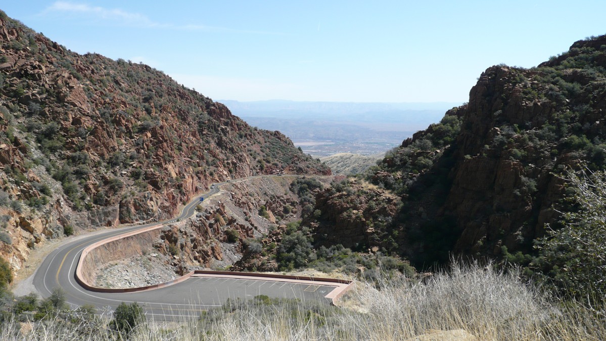
Mingus Mtn, Cottonwood, AZ Begin this climb in Cottonwood on Rt 89A. The shoulder quickly disappears, and there can be a fair amount of traffic on this highway that connects Prescott and Sedona with Cottonwood in the middle. The grade is mostly gradual, but strangely the steepest pitches are in the old mining village of Jerome. You start to get nice views here, and above Jerome there are scenic vista pull-outs. The narrow road winds up a canyon for a ways until the grade levels off slightly as the pass through the mountains approaches. There is only one significant downhill on the way up, losing maybe 200ft. The rest is all up or maybe briefly flat. If you stay strictly on pavement, you climb for about 16 miles. Taking a left on dirt FR-104 can bring you to summit of Mingus, another three miles of well groomed gravel and several hundred feet more vertical. Hang gliders launch into the abyss from the cliff ledge here. View towards Sedona with red rock cliffs in distance is dramatic.
|
|
|
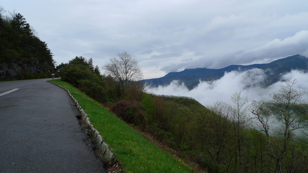
Mt. Mitchell, Marion, NC Mt Mitchell is the highest peak east of the Mississippi, contrary to what some New Englanders believe. Mitchell's summit rises nearly 400ft higher than Washington's. The approach is many miles longer, however. It is not all up. There are significant downhills along the way. The approach presented here links up Hwy 80, the Blue Ridge Parkway and the Mt Mitchell summit road. Once up on the BRP, the scenery is stunning. Photo to left is from the BRP on a damp, April morning. This is one of the few places riders can gain a vertical mile in less than 30 miles distance east of the Mississippi. A vertical mile can be gained on Mt Washington by starting from Jackson or Gorham, but this can only be done during the practice climb days reserved for registered racers. Mt Mitchell can be ridden anytime the road is clear of snow.
|